
Queensland Police warns boaties to stay out of the water as unusual weather system forms off Gold Coast
Weather warnings have been issued for the Gold Coast as a developing east coast low tracks south. Here’s what to expect into the weekend.

Gold Coast
Don't miss out on the headlines from Gold Coast. Followed categories will be added to My News.
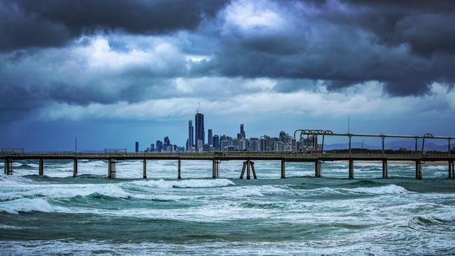
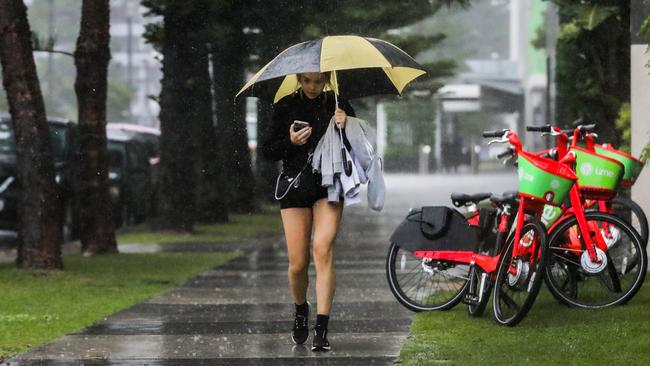
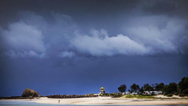
A Severe Weather Warning has been issued for the Gold Coast as a developing east coast low tracks south, bringing rain and hazardous surf conditions.
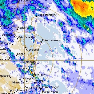
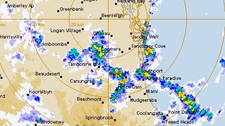
The low off the Queensland coast was predicted to deepen throughout Friday before starting to move away to the southeast on Saturday, according to the Bureau of Meteorology.
Forecasters flagged about 35 millimetres of rain in the city on Friday, but only up to 2mm on Saturday. They also warned of wind gusts of up to 45-50kmh through Friday-Saturday.
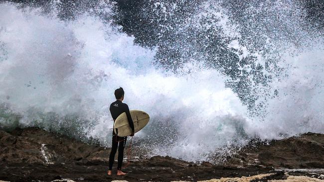
But the low has stirred up “large and powerful surf conditions”, which will be too dangerous for activities such as boating, rock fishing, swimming and surfing.
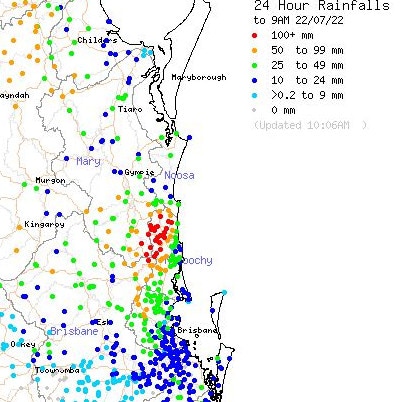
In the 24 hours to 9am on Friday, parts of the Gold Coast Hinterland were drenched by more than 115mm. Upper Springbrook recorded 117mm, while Mudgeeraba recorded 55mm and 28mm fell south at Coolangatta.
The Gold Coast Seaway received just 11mm, while north at Pacific Pines 46mm of rain fell and Norwell received 12mm.
The bureau warned the low has been “interacting with a ridge to the south to produce gusty winds and waves along the southern coastline”.
“Very heavy surf is forecast along the exposed southern Queensland coastline south of Sandy Cape today until early Sunday morning, which may lead to localised damage and coastal erosion” the bureau stated.
“Significant wave heights exceeding four metres from an east to south-easterly direction are expected”
A Hazardous Surf Warning and Marine Wind Warning have also been issued, with gale force winds due on the Gold Coast until at least Saturday.
City beaches have been closed on Friday and were due to remain closed on Saturday.
Forecasters watching waterways as low forms off Coast
July 21: Weather forecasters have issued a Strong Wind Warning which is set to be upgraded as an east coast low develops off southeast Queensland, bringing rain and possible thunderstorms.
The Bureau of Meteorology has flagged a likely Gale Warning for Friday and warned of deteriorating conditions into the weekend.
Damaging winds in excess of 90kmh may develop around the southeast Queensland coast and adjacent hinterland areas on Friday and early Saturday,” the bureau stated.
However, the low is expected to remain offshore and “primarily bring wave and wind impacts to coastal areas along the southern Queensland and northern New South Wales coastline”.
The strength of the wind and waves will be dependent on the strength and position of the low, which will be “closely monitored” in the next couple of days.
Meteorologists also suggested a Severe Weather Warning could be issued at some stage on Thursday, though that had not occurred as of 11am.
The bureau warned of potentially dangerous surf conditions, and boaties and others keen to hit the water have already been urged to rethink plans.
It’s likely the dangerous surf will persist throughout the weekend, causing “extensive coastal erosion”
Rainfall dubbed “unseasonal” by the bureau was forecast from Thursday in southern Queensland, including the Gold Coast, and Friday in northern NSW.
But the heaviest falls will likely occur offshore.
Nevertheless, some localised creek and river level rises are possible and the bureau has stated the requirement for a Flood Watch will be reviewed daily.
The bureau will be keeping an eye on creek and river levels due to soaked soil.
Queensland Police Service has warned people to avoid water-based activities as the low develops.
East coast lows are described by the bureau as intense low pressure systems which occur several times each year off the eastern coast of Australia on average.
Unusual weather system prompts police warning
July 20: Gold Coast boaties have been warned to stay out of the water as an unusual low forms off the Queensland coast, likely bringing gale force winds, damaging swells and substantial rainfall.
On Wednesday, the Bureau of Meteorology (BOM) warned of strong winds for Coast waters.
The bureau stated it has been monitoring the development of the east coast low off the southeast Queensland coast and forecasters flagged “an increase in winds, surf and rain”.
“The strength of the wind and waves will be highly dependent on the strength and position of the low relative to the coast and will be closely monitored during the next few days,” a bureau statement read.
“At this stage, although some unseasonal rain is expected from Thursday in southern Queensland and from Friday in northern New South Wales, the heaviest falls are expected to be located offshore.”
Queensland Police Service has urged people to avoid water-based activities as the weekend nears,
while the bureau will be keeping a particularly close eye on creek and river levels due to soggy soil.
“Soils remain wet for much of southeast Queensland and eastern NSW, and while the rain is not expected to cause widespread riverine flooding, some localised creek and river level rises are possible,” the bureau stated.
“The requirement for a Flood Watch will be reviewed each day.
“This system is expected to bring large seas along with the risk of damaging winds around exposed coastal fringes of southeastern Queensland.”
The bureau warned of strong south-easterly winds developing along the coast south of Mackay and extending into northern NSW from Thursday.
“The wind is expected to increase further, particularly from Friday, as the low deepens,” the bureau stated.
“There is a risk of damaging wind gusts of more than 90km/h on Friday and early Saturday around the exposed coastal fringes of firstly southern Queensland, then northern NSW.
“A hazardous east to south-easterly swell is also expected to develop along the southern Queensland and northern NSW coast on Friday and persist over the weekend as an East Coast Low develops in the Coral Sea well offshore of the southeastern Queensland coast and moves away eastwards.
“The swell may lead to coastal erosion in vulnerable areas along the southern Queensland and northern New South Wales coasts.”
The low could dump a month’s rain in about 24 hours in some areas, though the heaviest falls are expected north between the Sunshine Coast and Whitsundays
“This system is a bit tricky to predict at the moment so we can’t say with too much certainty where the heaviest falls will be,” bureau meteorologist Helen Reid said.
“We’d really urge people to refer back to the BOM website to keep up to date with what warnings impact them and what you need to know.”
“It might be a weekend to stay inside, it won’t be very pleasant near beaches this weekend.”
More Coverage


Originally published as Queensland Police warns boaties to stay out of the water as unusual weather system forms off Gold Coast

Named: Trio behind alleged targeted shooting at Parkwood
Police have charged a third man in connection with a Gold Coast shooting earlier this month that investigators believe was a targeted attack. His two co-offenders faced court previously.

Probe launched after 10 ‘aggressive’ dogs spotted on boat
An investigation is underway after 10 dogs were spotted on a Gold Coast boat, with authorities aware of the issue for months but unable to approach the vessel.