
Tropical Cyclone Alfred could hit the Brisbane CBD, according to new Bureau of Meteorology modelling
Tropical Cyclone Alfred could hit the Brisbane CBD, with residents warned of a risk conditions similar to the 2022 floods could hit the state.
Environment
Don't miss out on the headlines from Environment. Followed categories will be added to My News.
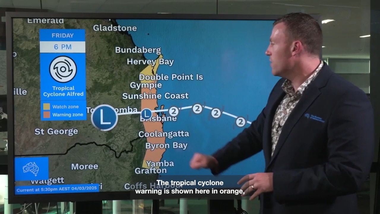
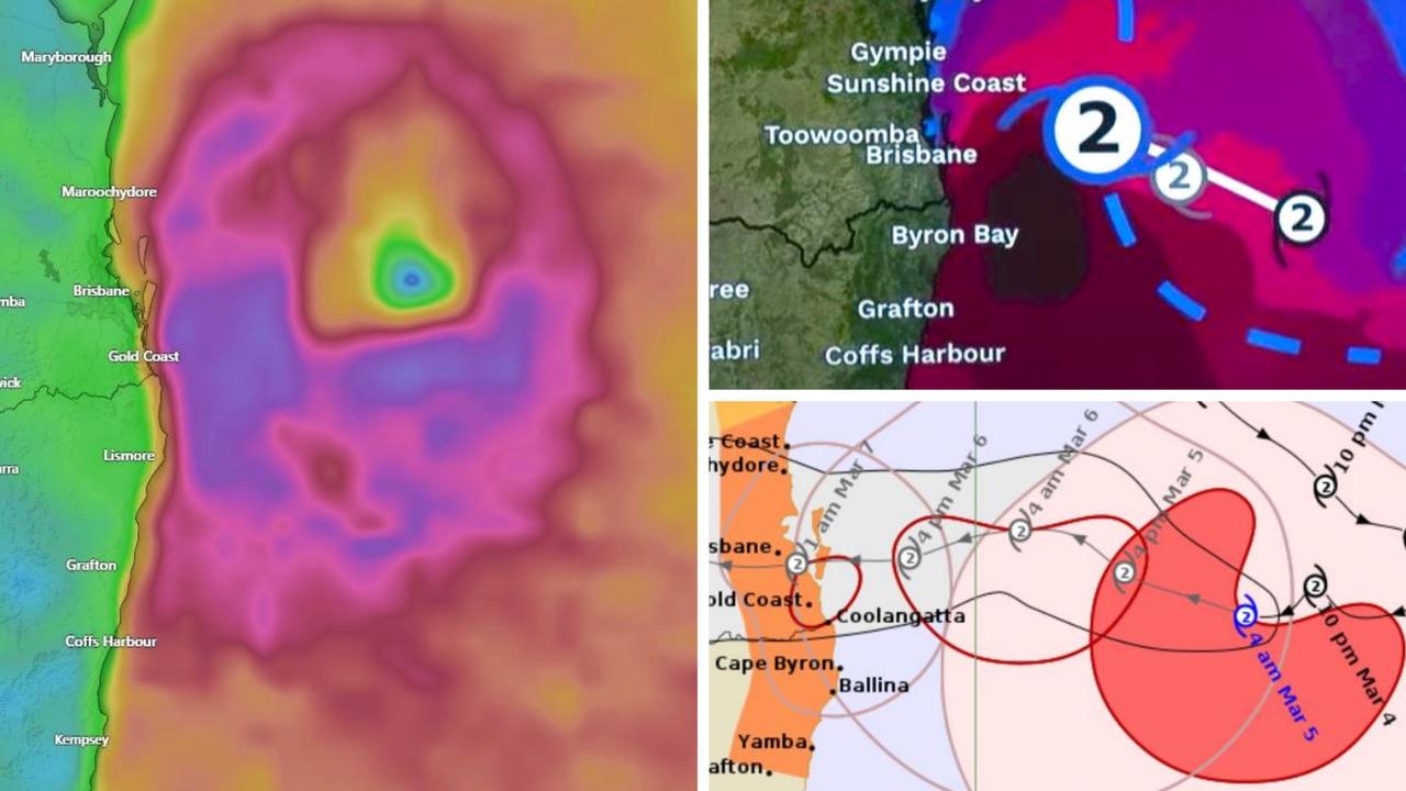
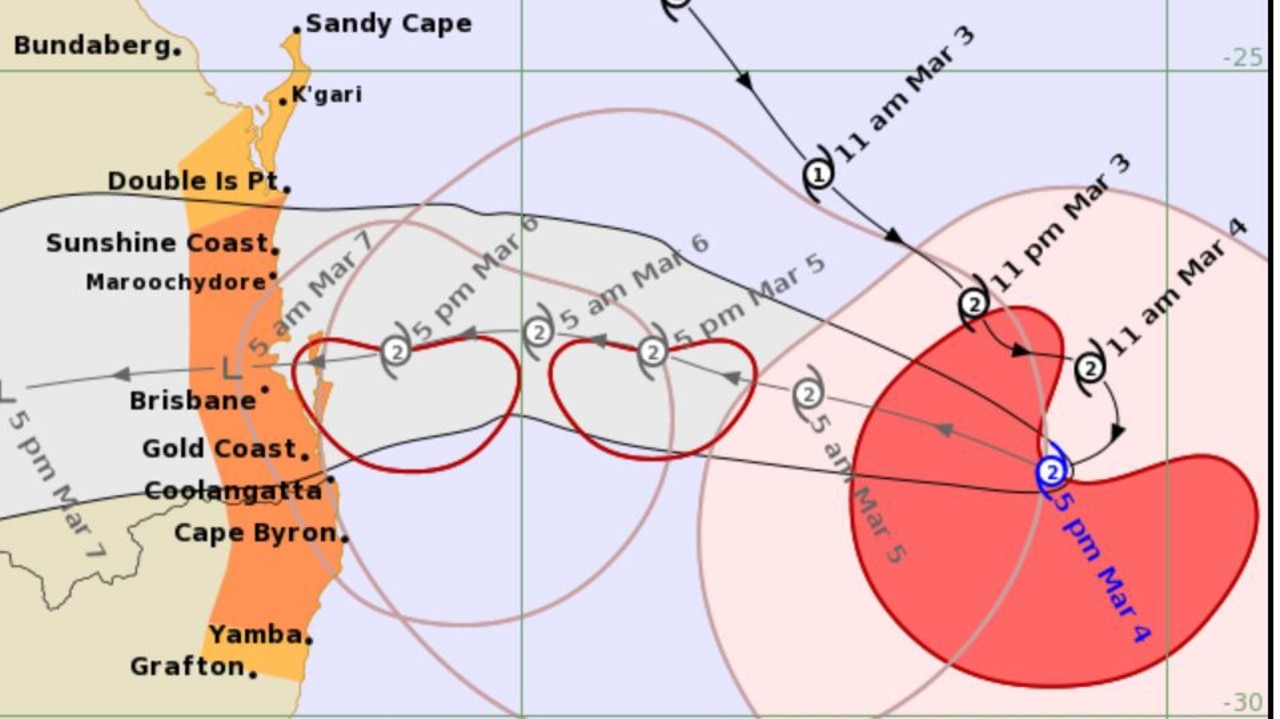
Tropical Cyclone Alfred is tipped to move directly over Brisbane’s CBD according to the latest modelling, with residents warned conditions similar to the 2022 floods could be on the way.
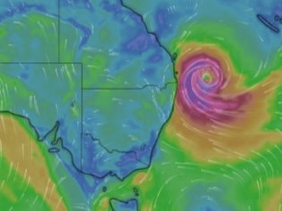
The category 2 cyclone was about 345 kilometres east of Brisbane and 315 kilometres east of Gold Coast as of Wednesday morning, moving west at 16km/h.
It is expected to make landfall between the Sunshine Coast and the Gold Coast by late Thursday night or the early hours of Friday.
The Bureau of Meteorology expects the cyclone will maintain its category two intensity as it approaches the coast.
The bureau declared a warning zone between Double Island Point in Queensland to Grafton in NSW, which includes Brisbane, the Gold Coast, the Sunshine Coast, Byron Bay and Ballina but not including Grafton.
The latest modelling from the Bureau of Meteorology showed the cyclone moving across Brisbane’s CBD.
However, the Bureau would not confirm where the cyclone would make landfall as the weather system is rapidly unfolding.
Brisbane Lord Mayor Adrian Schrinner warned a “2022 flood situation” could be on the way due to high rainfall total predictions.
“Although a slim chance, but there is a chance that we could get up to 700 millimetres across three days,” Mr Schrinner told ABC Radio.
“If that eventuates, then we’re talking about more like a 2022 flood situation.”
Mr Schrinner earlier said nearly 20,000 properties across Brisbane could be affected by the storm surge or flooding.
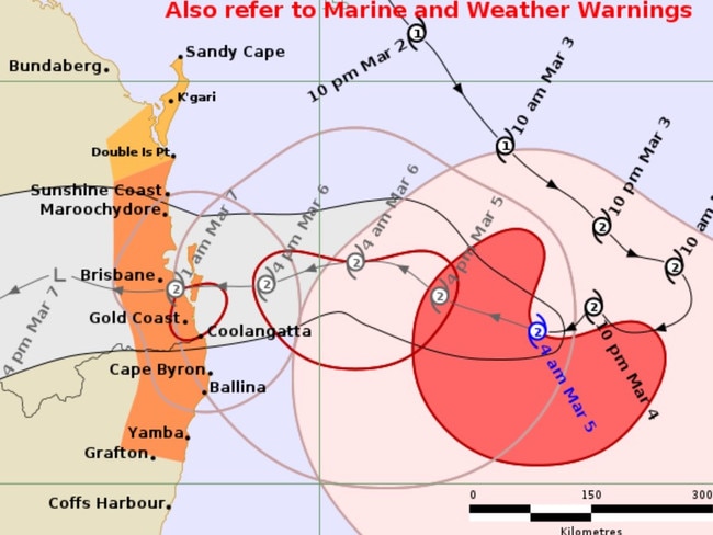
A technical report from the Bureau of Meteorology also warned the category 2 cyclone could be upgraded before it makes landfall.
“The current forecast has the system intensifying to a high end category 2 system … prior to landfall on Thursday evening or Friday morning,” the report stated.
“The possibility of the system reaching a low end category 3 strength before making landfall cannot be ruled out, but remains a low risk.”
$10m emergency alert technology not ready
People in the firing line of Tropical Cyclone Alfred will need to rely on state-run emergency alerts due to delays in the deployment of a $10m federal government disaster warning system, which was supposed to be brought in last year.
The National Messaging System (NMS), announced in 2023 by the federal government, would be able to send out alerts and warnings to all devices in affected areas in both English and a second language.
However a spokesperson for Emergency Management Minister Jenny McAllister said the state’s existing emergency alert system would instead be used during Cyclone Alfred, due to make landfall on Friday.
The existing system took up to 12 hours to notify people during the 2022 floods, with a review finding the properties of some Brisbane residents received the message “well after their properties were inundated”.
A spokesperson for Ms McAllister said the existing Emergency Alert System (EAS) was used by emergency services nationally to send voice messages to landlines and texts to mobile phones about potential emergencies within defined areas.
The spokesperson said the EAS was “always” going to be the primary messaging system in the 2024-25 High Risk Weather Season, but that the federal government was looking at “modernising the messaging technology that underpins the national system”.
“That is funded in our budget and work on that remains ongoing,” the spokesperson said.
“The Albanese Government is working with the states and territories and the mobile network operators to modernise the technology and systems that underpin a national messaging capability.
“The delivery of this system relies on all partners coming together, including the telecommunications companies.”
Prime Minister Anthony Albanese was set to fly into Brisbane on Tuesday evening after the federal government activated the Australian Government Disaster Response Plan and a Crisis Coordination Team.
Liaison officers were also deployed, and are undertaking crisis appreciation and strategic planning.
Effects of cyclone to be felt from Wednesday
Gales with damaging wind gusts of up to 120km/h are expected to hit from Wednesday, with warnings issued for communities between Double Island Point in Queensland and Grafton in NSW.
Bureau of Meteorology senior meteorologist Christie Johnson said winds were expected to increase along the coastal fringe of southeast Queensland and northern NSW on Wednesday, before extending inland throughout the day in the tropical cyclone warning area.
“We’ll also start to see showers and isolated thunderstorms on and near the coast becoming heavy at times later today,” Ms Johnson said.
Large waves and hazardous coastal conditions were tipped to continue, with damaging to destructive winds to develop on Thursday as the cyclone approaches.
“These are sustained winds that can cause significant damage to property and vegetation,” Ms Johnson said.
“We’ll also see that heavy to intense rainfall developing and isolated thunderstorms so we’re likely to see flash flooding, and then as totals build, riverine flooding developing as well — and of course those large waves and hazardous coastal conditions will continue.”
However she warned the “danger isn’t over” once the cyclone makes landfall.
“We will continue to see heavy rain and significant winds persisting and extending inland and down the NSW coast, and of course flooding impacts will continue over the weekend and into early next week.”
Residents between Double Island Point and Sandy Cape could be affected on Thursday if the cyclone moves further north.
Destructive wind gusts of up to 155km/h may develop from Thursday afternoon along coastal and island areas “as Alfred’s destructive core approaches and crosses the coast”, the Bureau alert stated.
A dangerous storm tide may also occur along the coastal foreshore, while abnormally high tides are likely to continue in low lying coastal areas between Sandy Gape and Grafton, particularly during high tides on Wednesday night, and Thursday and Friday morning and night.
Coastal erosion is likely for open beaches in those areas, the Bureau warned, while heavy to locally intense rainfall with the potential to lead to dangerous and life-threatening flash flooding could occur near and south of the cyclone’s centre on Thursday.
Brisbane City Council buses are set to cease from last service on Wednesday, The Courier Mail reported, while Queensland Rail Trains are tipped to stop once either winds reach 90km/h or the cyclone is 200km or 10 hours away from hitting land.
‘Prepare for the worst’: Minns
NSW Premier Chris Minns earlier urged people to listen to emergency communications and not to put themselves or volunteer rescue workers at risk by not driving through floodwaters.
“We hope for the best, but we prepare for the worst,” Mr Minns said on Today.
Just days on from the three year anniversary of the Lismore floods Mr Minns said this cyclone warning “brings back all the worst horrors of 2022”.
ADF ‘definitely ready’
Defence Minister Richard Marles said the government was “definitely ready” when asked whether the Australian Defence Force (ADF) would be deployed to Queensland.
The ADF has already provided more than 300,000 sandbags, and Mr Marles told the ABC that the he spoke with the ADF’s chief on Tuesday night to ensure “we are completely ready to provide the full assistance required”.
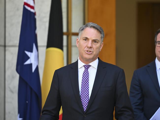
He said one of the ADF’s three biggest infantry brigades was based in Brisbane, while one of the two big air force bases is just west of Brisbane.
“These are two of the biggest Defence Force bases we have,” Mr Marles said.
“It provides a lot of personnel but also real options in terms of operating from both of these bases to provide assistance, and I would expect that in terms of knocking on doors, providing airlift in the event of flooding, that all of these may come into play and we are ready to do everything that is required.”
Events cancelled, postponed
Several events have been cancelled or postponed as the cyclone nears, including two AFL opening round matches.
Brisbane’s Thursday game against Geelong at the Gabba was postponed along with Gold Coast’s match against Essendon at People First Stadium on Saturday, the AFL said in a statement, following communication with the state government, Bureau of Meteorology and Stadiums Queensland.
AFL chief executive Andrew Dillon said he didn’t want the games to “be a distraction” to cyclone preparations.

An alternative schedule will be announced as soon as possible, the AFL said.
Punk rock band Greenday announced their Wednesday night Gold Coast show was cancelled due to the cyclone, with it “not possible to reschedule” due to the band’s international touring schedule.
“With Cyclone Alfred bringing some seriously nasty weather, it’s just not possible to go ahead safely,” the band said in a statement posted on social media.
“We know this is a huge disappointment, and we’re just as bummed as you are. Stay safe out there!”
Refunds will be processed within 14-21 days, Live Nation wrote in a post to Facebook.
‘Huge layer of complexity’: Crisafulli
Queensland Premier David Crisafulli urged people to clean up loose items and get all their valuables in one location while speaking on Today on Wednesday morning.
He said there was “no doubt” the cyclone “intensified a bit overnight”, and said a “huge layer of complexity” would be added if the cyclone made landfall overnight on Thursday.
“The time remains a little variable – now the Bureau are saying it’s somewhere between Thursday afternoon and Friday late morning,” Mr Crisafulli said.

“Now, if that was to happen around the 1:00 in the morning time on Friday, there are high tides about 1am, 1.30 on the Gold Coast.
“That brings a huge layer of complexity, which is why we are saying to people we will provide the information about what a storm surge looks like if it was to cross at that high tide, and councils will provide modelling which will show the impact zone as a result.”
Mr Crisafulli again urged people to “do the little things” to prepare for the cyclone.
“Stay up to date, you make sure you do the little things and in the end, your safety is what matters more to us than anything else,” he said.
“Roads and bridges and homes, they can all be replaced – people can’t.
“So we’re asking people to stay safe and we will do everything possible to provide that information in real time.”
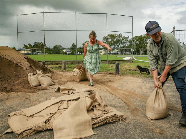
Supermarket shelves stripped bare
People have been flocking to supermarkets to prepare for the cyclone, with many shelves stripped bare.
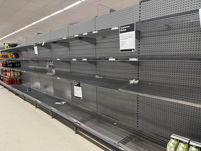
Bottled water sold out across multiple Queensland suburbs on Monday, The Courier-Mail reported, with milk and bread also running low.
In NSW, toilet paper and bottled water were in low supply in Lismore on Tuesday, while high clearance rescue vehicles were deployed in the Lismore area in preparation for the cyclone.
Mr Crisafulli earlier said supermarkets were told to “restock the shelves as much as you can”. He said Queenslanders should prepare to be without power and stock up on water, spare batteries and phone chargers.
“There is no harm in preparing and then not needing it,” Mr Crisafulli said.
“The harm is in not doing the work and – then when things become in a perilous situation if it gets to it – not being ready.
“So just do the little things, if you do the little things people will get through it.”
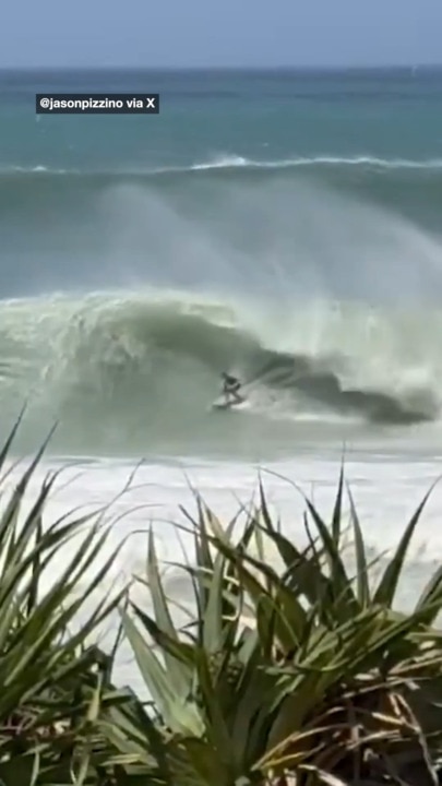
‘Incredibly large’ 9m waves
The bureau earlier warned rainfall of up to 200mm could be expected across parts of NSW and the Sunshine Coast; however, isolated falls could reach up to 700mm by the weekend.
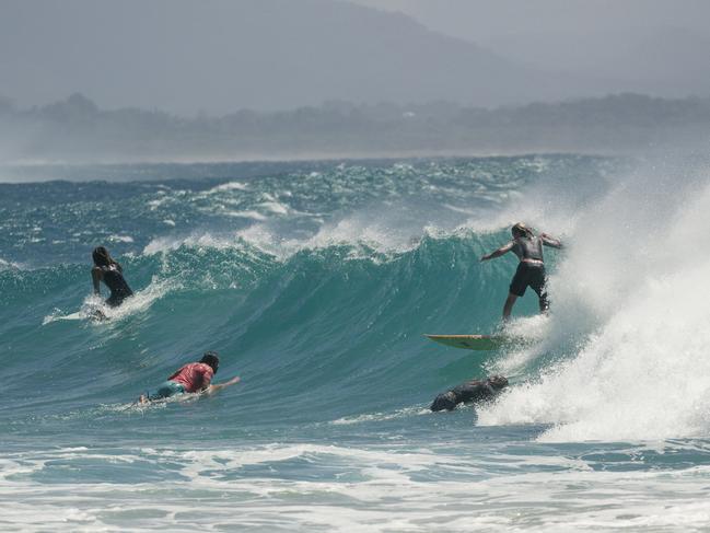
Waves up to 9m high could be on the way too, meteorologist Miriam Bradbury warned.
Some 7m waves have already been recorded in North Stradbroke Island, in the Moreton Bay region north of Brisbane.
“We’re already starting to see large waves (with) this damaging surf impacting parts of the southeast Queensland coast,” Ms Bradbury said on Wednesday.
“In addition to that we’re seeing dangerous conditions slightly offshore as well — large waves, seas and swell are anticipated over the next few days, growing towards the end of the week as the system nears the coast.
“Over the next couple of days, significant wave heights of 4m to 6m are quite likely through southeast Queensland and northeast NSW, but as we head towards Thursday and Friday we may see those significant wave heights pushing up to 7m, 8m or 9m.
“Those are incredibly large waves and do produce incredibly dangerous conditions for any activities out on the water.”
Coastal hazard warnings were issued from Sandy Cape in Queensland down to Smoky Cape in NSW.
More Coverage
Originally published as Tropical Cyclone Alfred could hit the Brisbane CBD, according to new Bureau of Meteorology modelling
‘CANNOT BE RULED OUT’: BoM issues dire warning, millions in danger zone
Tropical Cyclone Alfred could hit Queensland as a category 3 system, the BoM has warned, as millions brace for impact — forcing school closures and travel chaos as residents scramble.
Read more
Alfred makes U-turn, millions now in danger
Tropical Cyclone Alfred has changed course and is now headed directly for a huge population region, as Aussies are warned of “incredibly large” waves.
Read more