NSW coastal erosion: Tropics move south leading to more storms
The NSW coast could be increasingly battered by tropical storms if action is not taken on climate change. That’s the warning from a leading expert as new aerial images reveal the devastating impact of recent storms.
Environment
Don't miss out on the headlines from Environment. Followed categories will be added to My News.
Severe storms which have battered the NSW coastline in recent years could be “harbingers of things to come” if we don’t act on climate change, a leading expert has warned.
UNSW’s Dr Mitchell Harley said a devastating phenomenon called “tropical expansion” is resulting in the tropics moving further towards the poles, with south eastern Australia right in the firing line.
Experts believe the expansion of the tropics combined with the rise in sea levels due to unchecked emissions could spell disaster in NSW.
Meanwhile there are also projections sea levels could rise by 1m or more in the next century if emissions targets are not met, which could equate to the coastline receding by up to 100m – well beyond where our prime beachfront homes are built.
Doctor Harley, a senior lecturer at UNSW’s Water Research Laboratory, said Australia’s coastline is dynamic and it would not be unusual for certain beaches to come and go by up to 100m as part of natural processes unlinked to a change in the climate due to human activities.
This combined with tropical expansion has experts worried.
“With things getting more warm, we have a thing called tropical expansion which basically is the tropics moving closer to the poles,” Dr Harley said.

“We could eventually see tropical cyclones moving further south. We have started to see this effect in other parts of the world and it is huge concern for our region as well.
“What the expanding tropics could also mean is we have storms coming from unusual locations we haven’t seen in the past.”
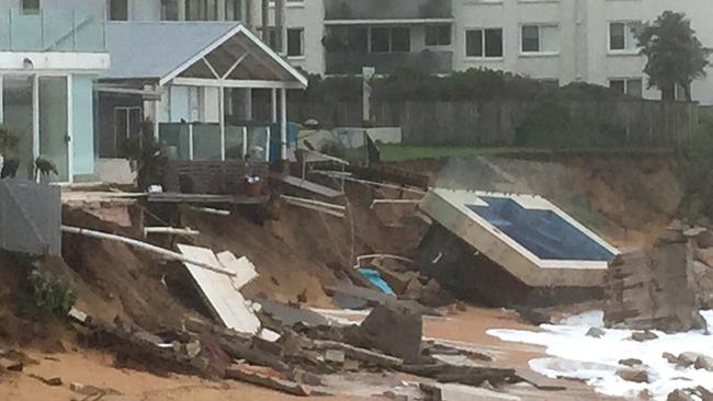
In 2016 a storm cell hit Collaroy and Narrabeen beaches. A swimming pool was swept onto the sand and Collaroy Beach Club teetered on the edge as 50m of coastline was swept away in an instant.
The same storm also caused significant damage further down the coast at Coogee.
“It wasn’t a particularly big storm, but it came from the east north east which is an unusual direction as most storms come from the south,” Dr Harley said.
“It caught our beaches off guard. Beaches are naturally quite well adapted to withstand storms from the south as they are protected by headlands.
“So when you get storms from a more northerly direction, the headlands provide almost no protection from waves and that’s when you get significant erosion.
“That 2016 storm could be analogous to what we could see lot more often in the future.
“You can’t be certain that as an isolated event it is attributable to climate change but it could certainly be a harbinger of things to come.”
In December 2020 storms lashed the NSW coast for days on end.
In Byron Bay where a shift in sand transportation patterns had already altered in the beach in the six to 12 months prior, the impact was devastating.
Meanwhile in Sydney, neighbourhoods surrounding the harbour foreshore are being subjected to increased “nuisance flooding” during king tides.
Dr Harley said while he was always very careful not to attribute isolated events to climate change, he and his colleagues were keeping a close eye on all of the above.
He also urged caution when it comes to future coastal developments as whether climate change related or due to natural processes, building too close to dynamic coastlines was not a good idea.
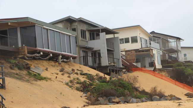
“Collaroy Beach and Wamberal in the Central Coast are examples of poor planning decisions made many decades ago ” Dr Harley said.
“When we start to build property and infrastructure in a dynamic zone it can cause lots of issues. We need to be very careful to not replicate the planning mistakes of the past”
The impact of the storms can clearly be seen in these stunning aerial images taken by Nearmap, an Australian location intelligence company with operations in Australia, New Zealand, the USA and Canada.
“Australia is a country prone to severe weather events, with conditions exacerbated by climate change,” M‘Shenda Turner, Director, Survey Operations ANZ, Nearmap.
“As natural disasters become more complex, unpredictable, and difficult to manage, organisations must take advantage of every available tool to help them plan for catastrophes and support those impacted.
“Nearmap provides high quality, city-scale aerial imagery and location data within days of major natural catastrophes to better support community recovery efforts and enable organisations to rapidly assess and understand the situation on the ground following natural disasters and extreme weather events, at a time when ground access can be limited, and inspection resources are stretched.”

The UNSW’s Water Research Laboratory is also appealing for help to better monitor the coastline.
Everyone is encouraged to download the free citizen science app CoastSnap and upload the pictures they take at the beach.
More Coverage
Originally published as NSW coastal erosion: Tropics move south leading to more storms


