
Millions in firing line of 200-400mm deluge, 130kmh winds as BOM issues major forecast update on Tropical Cyclone Alfred
Millions of Aussies are bracing for rain deluges of up to 400mm and gusts of 130kmh as new forecasts reveal the terrifying path Tropical Cyclone Alfred could soon take.
Environment
Don't miss out on the headlines from Environment. Followed categories will be added to My News.
A cyclone watch has been issued for the first time since 1990 in NSW, as residents are warned Tropical Cyclone Alfred could bring “damaging” wind, waves and the potential for “intense” rainfall.
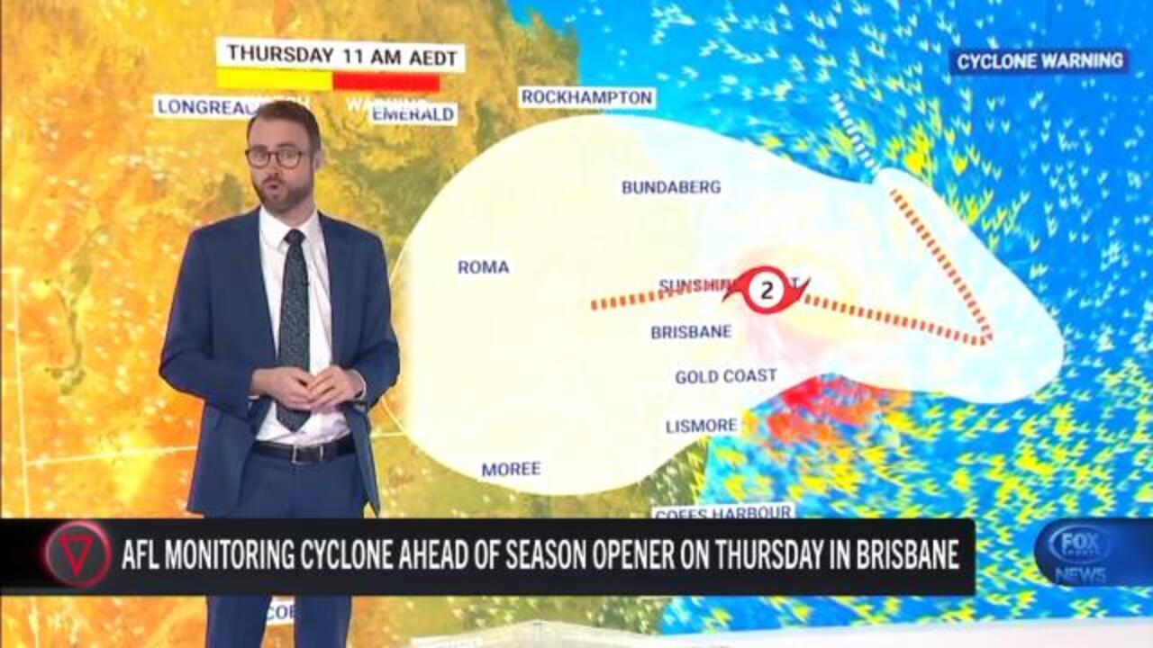
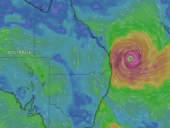
The Bureau of Meteorology has forecast the category 1 system will bring “damaging to destructive winds” strong enough to bring down trees, as well as heavy to intense rainfall and possible flash flooding, to swathes of the NSW and Queensland coasts from Wednesday.
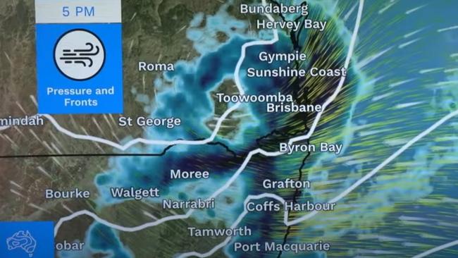
In their latest update, the bureau has forecasted the rain and wind will increase and build over Wednesday, continuing into Thursday.
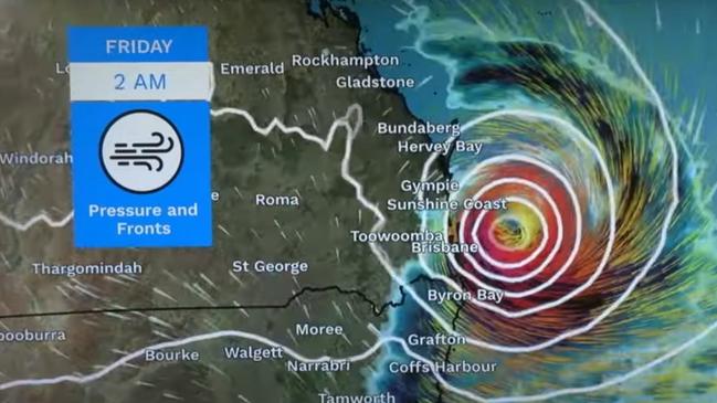
The peak of the system will hit on Friday – when Alfred makes landfall – and possibly continue into Saturday.
“The heaviest rainfall total is highly dependent on the path, intensity and the speed of the tropical cyclone,” BOM senior meteorologist Sarah Scully said on Monday afternoon.
“We do have the potential to have daily rainfall totals between 200-400mm possible.”
Multiple flood watches have been issued for catchments and rivers across both states.
Tropical Cyclone warnings have also been handed down for K’gari (Fraser Island), extending down to north of Grafton in NSW.
Gale-force winds of up to 63kmh – gusting in excess of 90kmh – are expected from Wednesday evening, Ms Scully said.
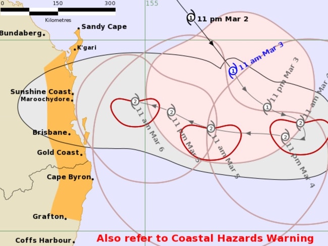
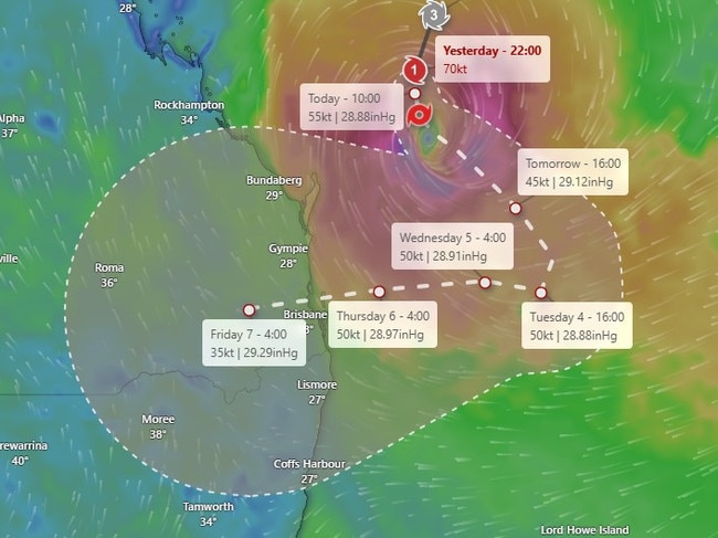
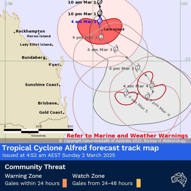
Tropical Cyclone Alfred is forecasted to strengthen into a category 2 system from Tuesday, before making a U-turn back towards the east coast.
“(There will be) a likely crossing either late Thursday night or in the early hours of Friday morning,” Ms Scully said.
Alfred was last reported about 465km northeast of Brisbane and 410km east northeast of Maroochydore on Monday morning.
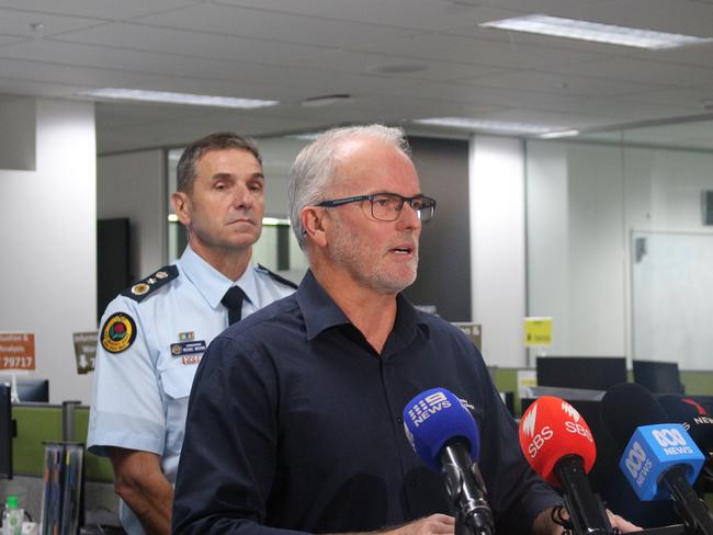
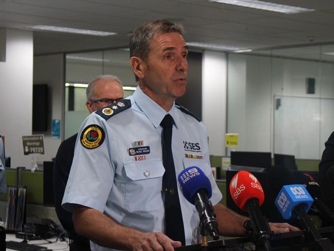
Bureau of Meteorology manager hazard preparedness Steven Bernasconi said it was the first time a cyclone watch had been issued for NSW since Cyclone Nancy in 1990, and before that Cyclone Zoe in 1974.
“This is unusual for NSW … We don’t often have tropical cyclones watches and warnings in the NSW jurisdiction,” Mr Bernasconi said at a press conference on Monday morning.
In 1974, about 500 families were evacuated in Lismore after the cyclone made landfall around north east NSW, with landslides and railway lines cut, Mr Bernasconi said.
“So depending on how this plays out, that’s the sort of impact we’re looking at,” he said.
He said NSW was forecast to experience gale-force winds within 24 and 48 hours as a result of the cyclone.
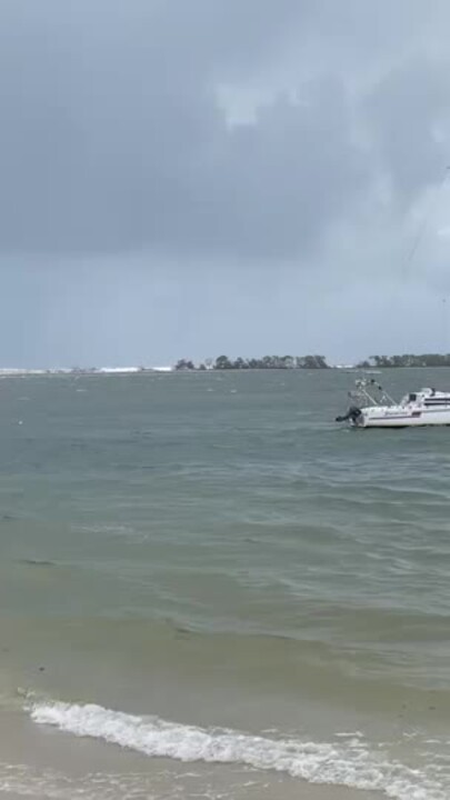
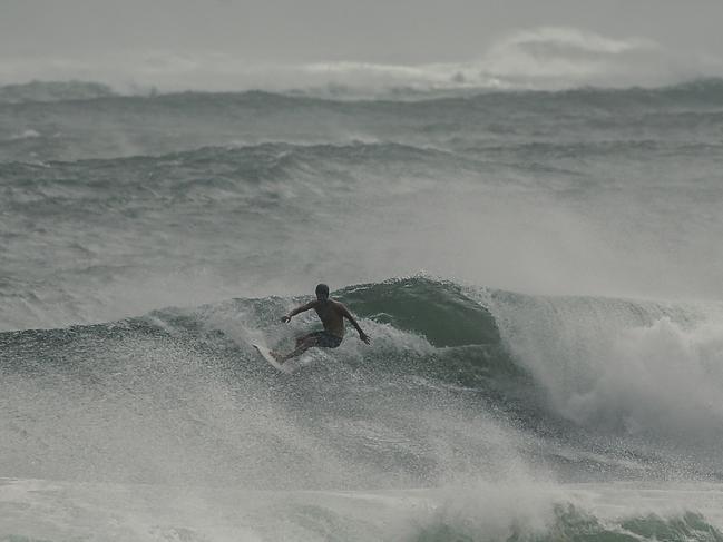
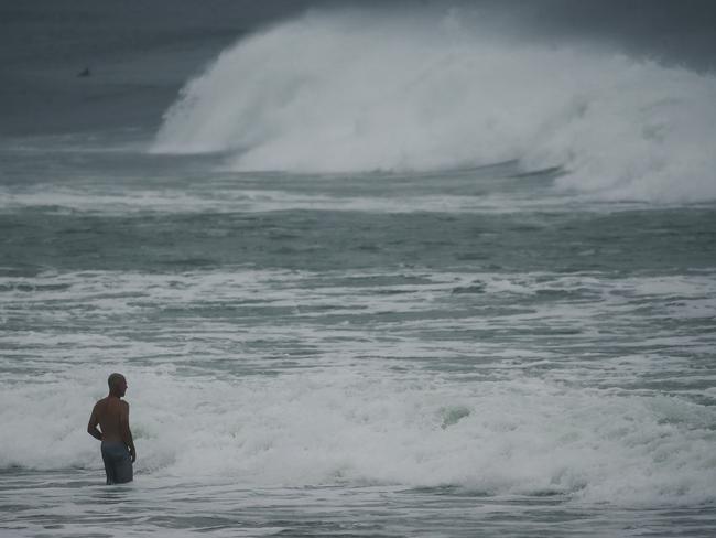
He said “large and powerful swells and waves” had already been recorded on NSW’s north east corner on Monday, with abnormally high tides expected on Tuesday.
“We can look towards Lord Howe Island, where wind and waves will start to be noticed and be noticeable in the in the damaging range. Wednesday, though, we start to see our increases impacting on the mainland,” he said.
“Winds will start to be noticeable and will be becoming damaging. Waves are likely to be damaging as well, and we would expect a coastal hazard warning around this time.”
He said there would be abnormally high tides and rainfall should increase into Wednesday evening, with the potential for “locally intense falls” moving into Thursday and Friday.
“Extreme winds” of 100km/h are expected towards Thursday and Friday, with waves in the south east having the potential to reach 8m high, while other offshore waves could reach up to 15m.
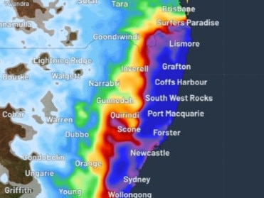
Mr Bernasconi said widespread rain between 100-300mm was tipped for Thursday and Friday, with flood watches in place.
The tropical cyclone watch spans from Sandy Cape down to the Coffs Harbour region in NSW; however, Mr Bernasconi declined to say whether metro areas of NSW would also be affected by the weather event.
“That’s the current watch area for the tropical cyclone and its impacts,” Mr Bernasconi said.
“There’ll be rain elsewhere, of course, and there’ll be wind elsewhere, but that’s the focus area.”
The cyclone was moving south-easterly on Monday but was set to move west on Tuesday, which would give experts “greater confidence” in its exact trajectory.
Mr Bernasconi said the timing of the cyclone crossing the coast was “still up in the air” but Thursday or Friday appeared most likely.
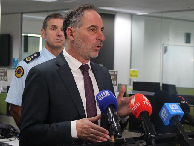
The NSW State Emergency Service (SES) will host community meetings over the coming days to ensure locals are informed.
SES Commissioner Mike Wassing urged locals to be prepared.
“Do really practical things in terms of cleaning up or removing any loose items from around their homes, acknowledging the significant damage that we will experience, irrespective of where the tropical cyclone may cross,” Mr Wassing said.
“We will be experiencing those high winds, heavy rainfall and the significant surf, irrespective of that location of crossing — practical things beyond the cleaning up of loose items around your home, if you need to be doing some sandbagging, now’s the time to do that.”
‘Be prepared’: Premier’s warning
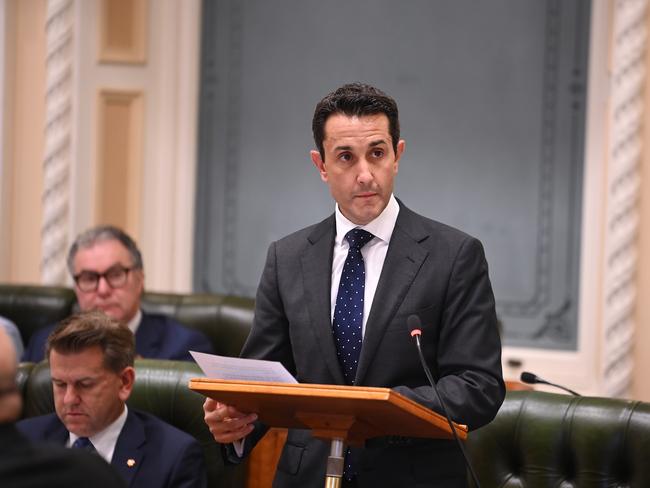
Queensland Premier David Crisafulli has urged Queenslanders in the firing line of the cyclone to be “prepared” – especially to the state’s island residents who could bear the brunt when the system makes landfall later in the week.
He said the government was pre-positioning items like generators in the event power, sewerage and telecommunications in the area went down.
Health workers were also being pre-positioned.
Mr Crisafulli said low-lying coastal areas – including those living on canals and beachfront properties – were the second priority and people in these areas needed to think about their plans ahead of the cyclone making landfall.

“We have been asking the councils to provide us with some of their storm surge data,” he told reporters on Monday.
“That will be important for all of us to communicate with residents.
“Because the timing of that crossing remains variable, there is the prospect it could cross on a high tide.
“That would provide a real complexity, that would provide some storm surge issues.”
Mr Crisafulli said the suburb of Golden Beach in Caloundra was a “particular area of concern” amid the heightened fears of the storm surge.
He said residents in the at-risk areas would face a choice of leaving or staying.
Earlier in the day, Mr Crisafulli told Sunrise the weather event was “packing a punch”.
“My message to people wherever you are … is right now, some of those swells are large and will get larger,” Mr Crisafulli said.
“We had reports of swells of somewhere in the order of 15m off the coast of Wide Bay. I’ve seen some of the erosion around some of the islands like Great Keppel.
“This system is packing a punch. All of the modelling are showing it heading west back towards the east coast somewhere between Bundaberg and the border.
“I want Queenslanders to take it seriously — we are, do your bit and we will get through it.”
Warning comes just days after anniversary of Lismore floods
NSW Minister for Emergency Services Jihad Dib said NSW was preparing for a “pretty nasty set of weather in the upcoming week”.
Just days on from the anniversary of the Lismore floods, Mr Dib said it “was not lost on (him)” that the area expected to be hit was northern NSW.
“We will do everything we can in working with that community, in making sure that our communities are well prepared, well protected, and can respond to whatever comes our way, Mr Dib said.
“It’s really important that all members of the public prepare for this event.”
He said information sessions with local MPs were set up and an additional area command was put in the area following the Lismore floods, with it clear things needed to be done “a little bit differently” than in 2022.
“I well and truly understand there’s an additional level of anxiety and stress given what they’ve gone through, and we will continue working with them,” he said.
“We’re doing everything that we can in terms of the preparation to make sure that we support all communities, and we’re cognisant of what the Northern Rivers have gone through and some of the trauma that they carry.”
Mr Dib urged people to listen to the advice of experts and leave if instructed to do so, as well as to download the Hazards Near Me app to stay up to date with alerts.
Cyclone on track to hit Brisbane by Thursday
While the Bureau of Meteorology warned the cyclone was expected to slow and head towards the southern Queensland coast on Tuesday, the latest modelling showed the cyclone could hit Brisbane by Thursday.
Queensland and NSW are both tipped to experience “severe” affects from the weather event as early as Monday.
“Severe coastal hazards are likely for southern Queensland and northern NSW coasts,” a Bureau of Meteorology alert stated.
“A large and powerful to potentially damaging easterly swell as well as abnormally high tides are occurring about exposed southern Queensland beaches, and are forecast to extend to northern NSW coast from Monday.
“Heavy to locally intense rainfall is forecast for southeast Queensland and northeastern NSW from Wednesday as Alfred approaches the coast. Flood Watches have been issued for these areas.”
‘Real-life nightmare’: Concerns for Bribie Island
Local community groups have warned the cyclone could have a particular impact on Bribie Island just years after the island’s northern tip was ripped in half by Tropical Cyclone Seth in 2022.
Camping bookings in the area have also been rejected by Queensland Parks and Wildlife Services.
Pumicestone Passage Catchment Management Body (PPCMB) spokeswoman Jen Kettleton-Butler told The Courier Mail Caloundra and Golden Beach could face a “real-life nightmare” if the cyclone were to cross the Sunshine Coast.
“What’s even more concerning is that within a week, we may see that risk crystallise into a real-life nightmare, as Golden Beach and Caloundra would be sitting ducks if Tropical Cyclone Alfred crossed or lingered near the Sunshine Coast,” Ms Kettleton-Butler said.
“Emergency action needs to be taken in the next few days to shore up the fragile sections of Bribie Island that will be next to go in a storm event, making fixing the problem even harder and more expensive.”
Calls for the government to protect the island with a rock wall or dredge sand were also put forth.


Rower rescued as cyclone approaches Brisbane
A Lithuanian rower has been rescued after he attempted to row from San Diego to Brisbane.
An (Australian Maritime Safety Authority) AMSA spokeswoman said Aurimas Mockus was rescued on Monday morning.
“Aurimas Mockus has been rescued by the Royal Australian Navy ship HMAS Choules,” the spokeswoman said.
“The ship on its way back to Australian shores.”
An AMSA spokesman earlier said AMSA had communicated with Mr Mockus through an interpreter and that he hadn’t reported any major injuries.
“The Royal Australian Navy ship HMAS Choules is still en route from Brisbane to the Coral Sea and is expected to arrive at the location tomorrow morning (Monday),” the spokesman said on Sunday afternoon.
“Weather conditions have eased slightly; however, the area is still within the influence of Tropical Cyclone Alfred with winds up to 100km/h and 5-7m seas.”
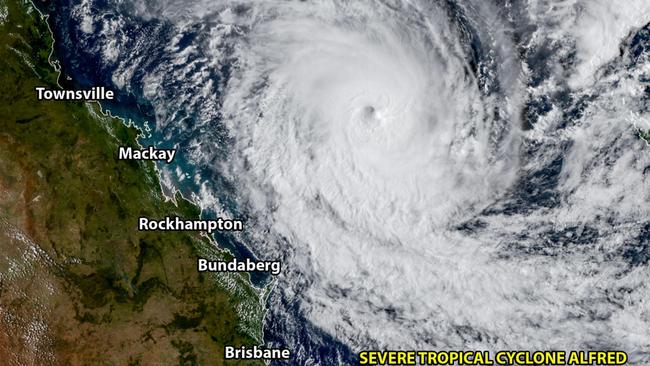
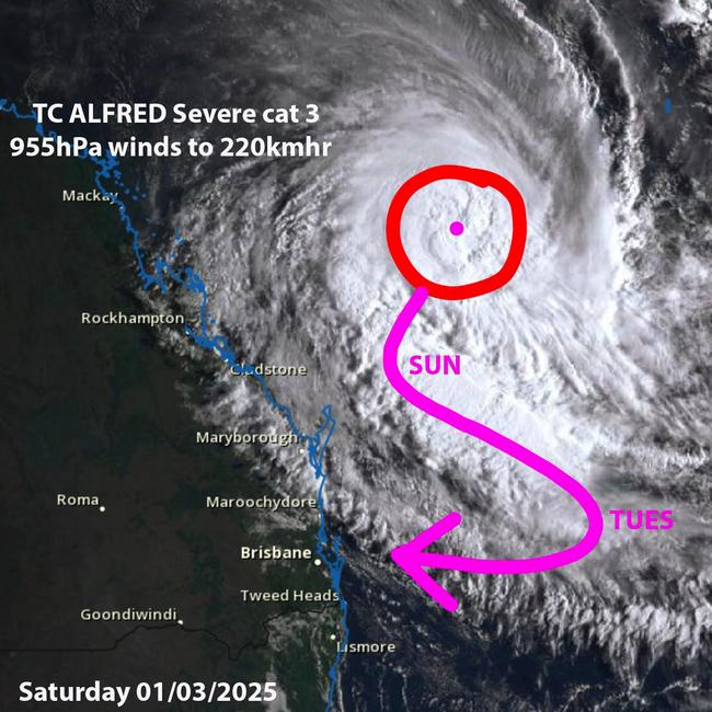
Bureau of Meteorology meteorologist Jonathon How on Monday said wind gusts of 130km/h were recorded near the centre of the cyclone, which was moving at “a running pace” of 13km/h towards the state’s south east.
Marine wind warnings were put in place from Gari down through the Sunshine Coast, Gold Coast and northern rivers of NSW.
“That’s for strong to gale force winds, and we’ll see those strong winds extending down to even the mid north coast of NSW over the next few days, so that is for very strong winds over the coast and also further off shore as well,” Mr How said.
A coastal hazard warning was also issued for parts of the Queensland coast.
“That is for very powerful waves ….as well as abnormally high tides,” Mr How said.
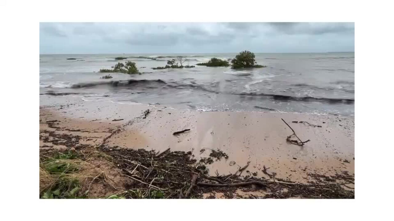
“The combination of very powerful waves and these high tides does mean that we are already seeing beach erosion across southern parts of Queensland.
“Those high tide peaks will gradually start to recede from today, but those strong waves … will persist for several days.”
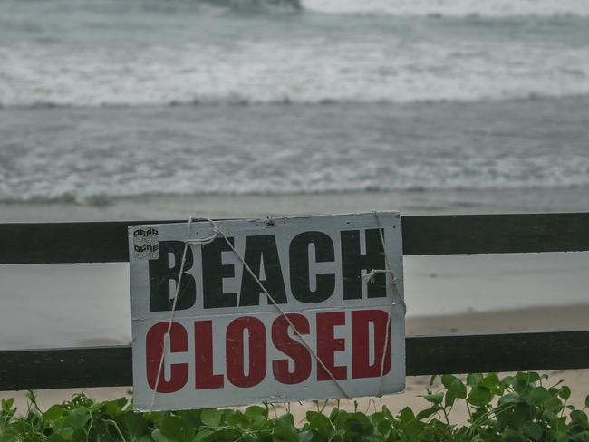
Residents warned of ‘dangerous and life-threatening’ flash flooding
Mr How warned swimming, boating and rock fishing could be “dangerous” amid a hazardous surf warning for parts of the southeastern Queensland coast and northeastern NSW.
An initial flood watch for both states was also issued ahead of heavy rainfall set to increase from late Wednesday into Thursday and Friday.
Mr How said “heavy to intense rainfall leading to dangerous and life-threatening flash flooding” was expected through the week.
A moderate flood warning was issued for Cooper Creek, as well as a minor flood warning for the Thomson River and initial flood watch for south east Queensland.
Final flood warnings were issued for the Diamantia River and Norman River.
An initial flood watch was also issued for the NSW Northern Rivers and the Mid North Coast, with the Bureau of Meteorology warning the tropical cyclone could cause moderate to major flooding in the area from late Wednesday to Thursday.
The NSW SES earlier warned the cyclone could produce flash flooding and river floods, damaging winds and heavy rainfall across much of northern NSW in an alert issued on Sunday afternoon.
NSW SES assistant commissioner Dean Storey said NSW resident across the impact zone should prepare now.
“The impacts of the cyclone may be felt from Tuesday with damaging winds, large powerful surf, coastal erosion, followed by intense and heavy rainfall from Wednesday onwards,” he said.
“If major flooding occurs, people may be asked to evacuate their homes.
“We are asking the community to take steps now to ensure that if you are asked to evacuate you have a plan for yourselves, your families and your pets and know where you will go.”
Meanwhile, southern Queensland was battered by strong winds and huge swells over the weekend.
The Bureau of Meteorology issued an update on the category two system just before 5am on Sunday, stating Alfred was forecast to move southward and weaken “roughly parallel” to the Queensland coast on Sunday, before moving to the southeast on Monday.
“Alfred is then expected to slow down and is likely to turn westward from Tuesday, moving back towards the southern Queensland coast,” the Bureau said.
Tropical Cyclone Alfred is currently moving over the Coral Sea about 510 km east of Rockhampton and is expected to cause strong to gale-force winds around K’gari (Fraser Island) on Sunday.
“Severe coastal hazards are likely for southern Queensland and northeast NSW.
“A large and powerful to potentially damaging easterly swell as well as abnormally high tides are forecast about exposed southern Queensland beaches, possibly extending to northern NSW from Monday.”
Thomas Hinterdorfer from Higgins Storm Chasing told The Courier-Mail on Saturday the major models they were using suggested Alfred would begin tracking west to Queensland throughout the week.
“Nothing before Tuesday says a landfall is expected, but then from Wednesday onwards, it gets a little bit more interesting with the model scenarios as they’re currently playing out,” Mr Hinterdorfer said.
“There’s definitely the possibility of it from probably Wednesday onwards or midweek onwards. Several models have that scenario at the moment but, of course, we need to let them play out a little bit more just before we hard lock it.”
Mr Hinterdorfer took to Facebook on Sunday morning warning southeast Queensland and northeast NSW residents to be prepared for landfall.
“It’s been 33 years since a tropical cyclone has made landfall as a categorised system in southeastern QLD … and it looks like that streak or drought is about to come to an end,” he wrote.
“All model guidance continues to suggest that Tropical Cyclone Alfred is forecast to make landfall over southeast QLD next week.”
The bureau encouraged residents and communities living on the Queensland coast and the northern NSW coast to stay up to date with the latest tropical cyclone information and forecast tracks on its website in the coming days.
Originally published as Millions in firing line of 200-400mm deluge, 130kmh winds as BOM issues major forecast update on Tropical Cyclone Alfred

Shop shelves emptied as cyclone looms
Supermarket shelves carrying one Aussie staple have been stripped bare amid forecasts of Tropical Cyclone Alfred crossing the east coast.
Read more

Pictures of rower’s rescue from cyclonic seas
Wild pictures have captured the moment a rower on a daring 12,000km solo venture was rescued from the rough seas of Tropical Cyclone Alfred.
Read more