
Northwestern NSW residents on high alert as cyclone moves west
The impact of Ex-Cyclone Alfred is still being felt in many communities, while the worst appears to have passed in others.
Environment
Don't miss out on the headlines from Environment. Followed categories will be added to My News.
While the impact of Ex-Cyclone Alfred is still being felt in many communities in northern NSW and southeast Queensland, the worst appears to have passed in others.
The ex-Tropical cyclone is now moving out west, with communities in north western NSW warned of potential wild weather in the coming days.
The East Kempsey CBD was told to prepare to evacuate on Sunday night with the NSW SES predicting dangerous flooding in the town.
Lismore’s flood warning’s have also been downgraded, allowing residents to “return home with caution”.
Meanwhile, about 350,000 homes and businesses remain without power in Queensland in the wake of the ex cyclone, according to the state’s premier.
Severe winds are also lashing the state’s south east and heavy rains continue to hit Hervey Bay, where more than 30cm of rainfall was recorded since 5am.
‘685 closures’: Call on QLD schools amid cyclone
On Sunday evening, the Queensland Department of Education published a list of schools which are set to be shut on Monday amid the wild weather.
In total 685 schools will shut, including 426 state schools, 170 independent schools, and 89 catholic schools.
The state premier said on Sunday each school would open on a case-by-case basis.
The full list of school closures can be found on the Queensland Department of Education website.
NAPLAN testing is scheduled for Wednesday. The standardised tests will go ahead in unaffected regions on March 12. Schools which are unsafe to open for students will do the NAPLAN tests on March 17, the Premier said, though this can be pushed back a further week.
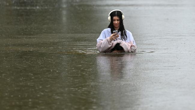
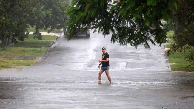
Residents warned to stay out of flood waters
Residents in flood zones are once again being reminded to stay out of floodwaters after incredible images revealed residents were wading, and taking selfies in the water - among other things.
While the wild weather continues to lash the state, some Queenslanders don’t appear too phased, with one woman spotted wading waist deep in the flooded Edmondstone Street in the Brisbane suburb of Newmarket.
She appears to be trying to take a selfie.
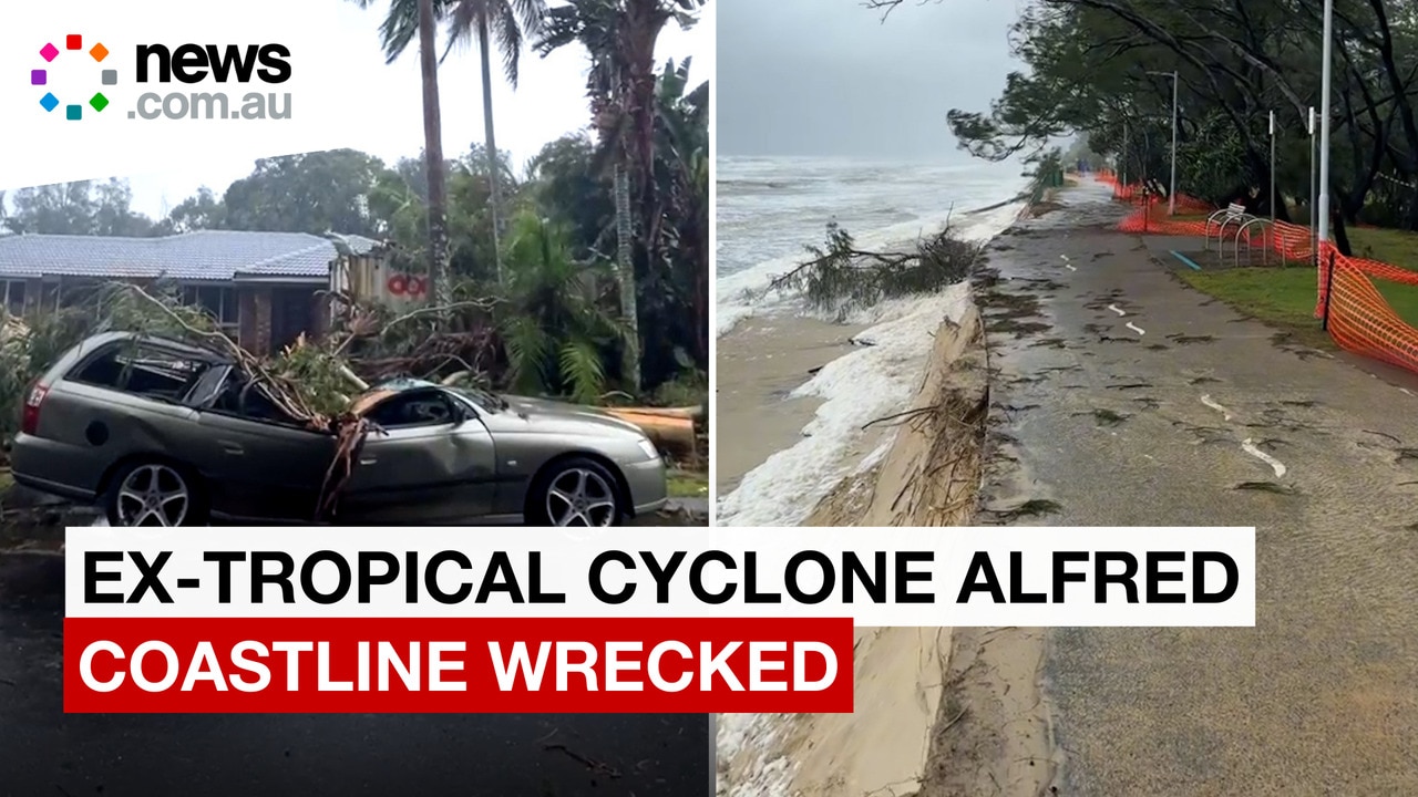
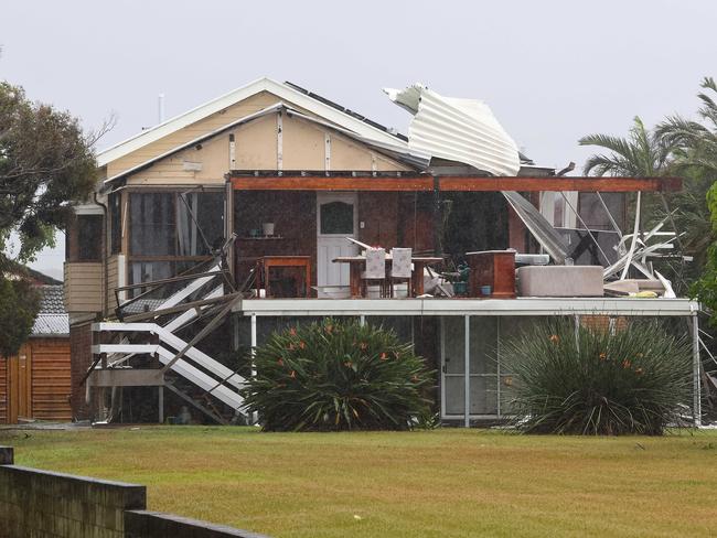
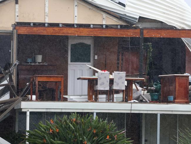
Shock pics of house torn apart by ex-cyclone
Meanwhile, houses have been torn apart by ex-Tropical Cyclone Alfred in Brisbane.
Images taken by NewsWire show a house in the seaside suburb of Brighton, where the wall of a second story living room has been ripped off. The tin roof has been curled up by strong winds. A wooden dining table and chest of drawers have been left exposed to the elements, as the rain from ex-Tropical Cyclone Alfred pours across the region.
Brighton is about 35km west of where the cyclone hit Moreton Island, and 45km south of where the downloaded tropical low crossed the mainland.
Lismore warnings downgraded
The threat of flooding in Lismore has been downgraded from major to moderate.
All eyes were on the town’s levy as rainfall intensified Saturday night, with the memories of the fatal 2022 flooding still fresh.
However, the Bureau of Meteorology has allayed some fears on Sunday afternoon, as the flood threat level was downgraded.
“Moderate flooding continues along the Wilsons River at Lismore, where river levels peaked at 9.31 metres on Saturday afternoon and is expected to fall slowly during Sunday,” a bureau warning issued at midday Sunday says.
“A severe weather warning is current for heavy rainfall for the Northern Rivers. This rainfall may cause renewed river level rises at Lismore. The situation is being closely monitored and warnings will be updated as necessary.”
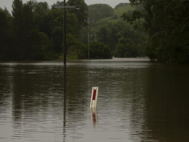
At 11am, only one of the key Wilsons River gauges is rising, while four hold steady and two recede.
Speaking from Lismore, Premier Chris Minns said news of flood downgrades for the Wilsons River was encouraging.
“I’m happy to report that the evacuation warning … has been lifted for the Lismore CBD,” the Premier said.
“To give you an idea of the volatility of the situation as it currently stands, the SES has issued ‘prepare to evacuate’ notices for low-lying communities near the Clarence River.
Around the Clarence River - the western side of the Northern Rivers - heavy rain was falling in the early Sunday afternoon, Mr Minns said.

“This is a fluid situation. The rain is falling unevenly across the catchments.”
The Premier reminded everyone to download the Hazards Near Me app.
Essential Energy had restored power to about 30,000 houses since Saturday, with about 14,000 still without electricity mostly around the Tweed area, Mr Minns said.
About 500 to 600 electricians, linesmen and electrical engineers were in the Northern River ahead of the cyclone’s worst effects, the Premier said, which warranted “a big round of applause” for Essential Energy.
“We’re not out of the woods yet. We’re watching, very closely, the river systems in the Northern Rivers.”
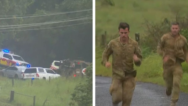
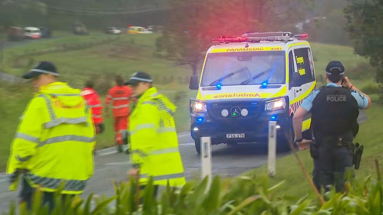
Update as ‘heroes’ injured in army truck crash
A dozen soldiers remain in hospital after a crash in flood zones near Lismore as ex-Tropical Cyclone Alfred continues to lash Northern NSW and southeast Queensland.
A major emergency response was launched on Saturday evening after two Defence vehicles carrying 36 people crashed on Tregeagle Rd in Tregeagle about 9km southwest of Lismore just after 5pm.
A Defence spokesman said 13 of the 36 personnel on board the two vehicles were injured.
Twelve of the soldiers are still in hospital, as of Sunday afternoon, two in a serious condition.
Prime Minister Anthony Albanese thanked the ADF crews on Sunday afternoon.
“These men and women are heroes who were on their way to help people in need,” Mr Albanese said.
“They were doing this at a time when some of their own families were bearing the brunt of Alfred.
“We will never take for granted the enormous sacrifice our soldiers make for us, and we will do all we can to support those injured and their families.
“We thank them for their service, yesterday, today and every day.”
It’s understood some people were trapped following the incident, but not for a prolonged period of time.
Sunshine State still in blackout
Speaking on Sunday afternoon, Queensland Premier David said there had been well over 200mm of rain in two hours in Hervey Bay, resulting in multiple flood rescues.
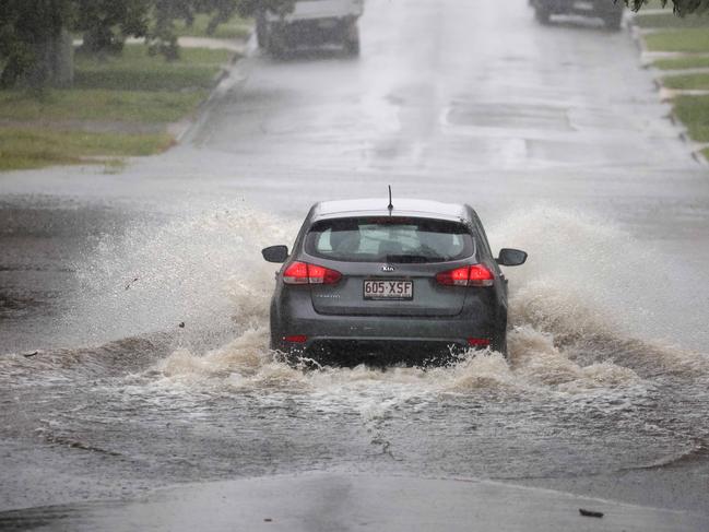
In the hours across midday, the heavy rainfall continued to “pack a punch”, sparking flash flooding in creeks, particularly around Brisbane.
“As the last of this system runs through, please look at those maps and know your situation.
“Go to the disaster.qld.gov website … have a look at how those maps relate to your property. Have a plan in place.”
The Premier thanks communities in and around Redcliffe in how they responded to the weather system.
“We’re going to continue to see that rainfall in the short term.”
The Queensland SES received more than 1000 calls fer help on Sunday, about one-third for damage to houses, another third for fallen trees. More than 100 extra police officers have also been out helping, plus over 850 fire and rescue “troops”, the Premier said.
Energex crews had been “out in force”, Mr Crisafulli said.
“Since the start of this event, we are looking at somewhere in the order of 450,000 homes and businesses that have had power loss.
“As of right now, it’s still over 300,000,” he said at 1.40pm AEST Sunday.
The Premier thanks Energex crews at the Brisbane depot earlier in the day.
Before the weather system made land fall, 1200 Energex workers were in position, and 800 had come from Ergon in the northern half of the state.
“I look forward to seeing some of them, and thanking them for their efforts in the days ahead.
The Premier thanked public transport drivers who went to work on Sunday so other essential workers could get to work. Buses across the state will be running Monday, except on the Gold Coast and Hervey Bay.
Brisbane trains will run on a Sunday timetable on Monday. Buses will replace trains on the Caboolture to Sunshine Coast route.
Gold Coast trams need 24 hours after electricity is restored to start running again, so the light rail will not be running on Monday.
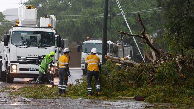
Flash flooding has disabled traffic lights across the state’s southeast, with 240 road crews out and about on Sunday working to get the lights going again.
Blackouts
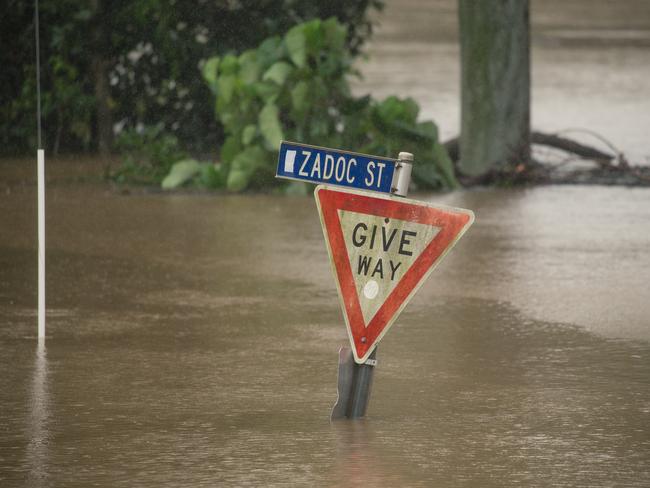
Towns in NSW face major flood warnings on Sunday as hundreds of thousands of people sit in darkness.
Authorities continue to warn people in southeast Queensland and northeast NSW that the effects of ex-Tropical Cyclone Alfred are far from over, with seven major flood warnings or severe weather warnings across the two states.
“The situation in Queensland and northern New South Wales remains very serious due to flash flooding and heavy winds, heavy rainfall, damaging wind gusts, and coastal surf impacts are expected to continue overcoming days,” Prime Minsiter Anthony Albanese said on Sunday.
“I urge everyone to continue to listen carefully to the emergency authorities.”
More than 300,000 Queensland power connections have been knocked out. About 16,000 homes and businesses were in darkness in NSW at 6am Sunday.
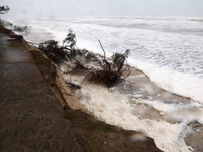
As ex-Tropical Cyclone Alfred moves to inland Queensland on Sunday, gust around 100km/h are being recorded. Flash flooding is occurring at Hervey Bay where 150mm fell in two hours to 6.30am.
About 500,000 people live in the city of Moreton Bay - residents were issued a severe weather alert at 8.45pm asking them to stay indoors.
“Dangerous winds are impacting parts of City of Moreton Bay now, especially around Redcliffe Peninsula. People should move or stay indoors now to be safe,” the alert read.
“Conditions could be very dangerous. Damaging winds have created multiple hazards in areas around homes and roads.”
One man died after being swept away by floodwaters near Dorrigo, inland from Coffs Harbour, on Saturday.

NSW SES deputy commissioner Damien Johnson said 14,600 people were under various warnings. In place are 141 warnings in place, with 36 being emergency alerts.
“It’s really important the public continue to adhere the warnings. The vast majority of the public have … a very small minority are continuing to drive through the flood waters.”
In the past 24 hours, SES crews had been called to 17 instances of people driving into flood waters,” Mr Johnson said.
“Not only is it a danger to yourself and your family, it’s also dangerous for the volunteers, the emergency service workers who need to rescue you.”
People were rescued in all the 17 recent instances.
“I know that people are very eager and keen to get into their homes as soon as possible. The NSW SES is working very quickly to remove any evacuation warnings where we can; but it needs to be safe to do so.”
The NSW SES have been called to 917 incidents in the past 24 hours.
Mr Johnson thanked volunteers who had travelled from other regions to the northeast and mid-north coast to help, as well as those employers who let SES volunteers off work.
Electricity workers in NSW have a myriad of challenges trying to reconnect some 16,000 lost power connections.
In an update, Essential Energy says 16,000 homes and businesses are without power at 10.30am AEST Sunday.
Rising flood waters, swollen creek beds, fallen vegetation and mudslides blocking roads are stopping workers getting to fallen lines and damaged infrastructure, a spokesman said.
Even getting a helicopter up to check the damage was too dangerous, the spokesman said.
Tweed Heads to Grafton have the majority of the outages.
“Crews are working to clean up, repair and restore wherever it is safe to do so, however, customers need to be prepared to be without power for several days.”
“Additional crews from across the Essential Energy network are travelling into the area today to assist.
“A big focus for today is to work on the restoration of power at Mount Nardi (which) is home to several transmission towers for FM radio, digital television, fixed wireless broadband and some mobile phone services.”
Flash flooding is possible for parts of the Northern Rivers, the Dorrigo Ranges, the mid-north coast and the Northern Tablelands on Sunday.
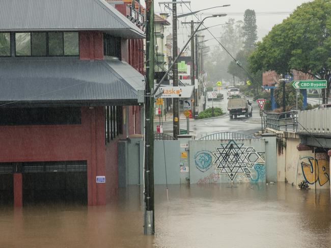
A warning from the Bureau of Meteorology, issued Sunday morning, spells trouble for huge swathes of the Queensland population.
“Locally intense rainfall which may lead to dangerous and life-threatening flash flooding may develop throughout today in bands of showers and thunderstorms over the Southeast Coast and southern Wide Bay and Burnett, possibly including Brisbane, Ipswich and the Sunshine Coast.”
“Six-hourly rainfall totals between 150 and 210mm and 24-hourly totals between 300 and 400mm are possible. If intense rainfall is detected, a separate Detailed Severe Thunderstorm Warning will be issued. Aside from flash flooding, there are five river catchments under major flood warnings on Sunday.
In NSW, the Tweed, Clarence and Richmond rivers are under major threat warnings.
People in the Northern Rivers, Northern Tablelands and parts of Mid North Coast and North West Slopes and Plains Forecast Districts are under threat of heavy rainfall and damaging wind gusts on Sunday.
In Queensland, the Bremer River and Warrill Creek, as well as the Logan River are a major flood threat.
Originally published as Northwestern NSW residents on high alert as cyclone moves west
‘Heroes’: Details emerge about ADF crash
One truck rolled several times into a paddock and another tipped onto its side, attempting to avoid the first vehicle.
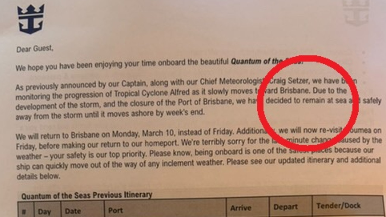
Cruise liner’s surprise letter to passengers
Aussies on-board a cruise ship have been forced to spend days longer at sea as ex-Tropical Cyclone Alfred loomed, throwing travel plans into chaos.