
Australia weather: Every state and territory facing heatwave
Every state and territory will cop a heatwave this weekend with some areas possibly even topping 50C.

Environment
Don't miss out on the headlines from Environment. Followed categories will be added to My News.
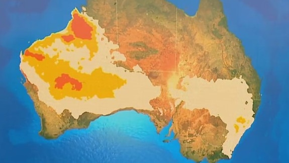
Every state and territory, at least in part, is likely to face a heatwave in the coming days as scorching late summer weather bakes the country.
A break in the monsoon has allowed sweltering air to build up in the Pilbara which is heading across Western Australia and the Northern Territory to the nation’s east with major cities in its sights.
“For Melbourne and also Penrith, it’s likely to be the hottest weather we’ve seen so far this summer as this heat slides on through,” Sky News Weather meteorologist Rob Sharpe said.
That could mean the mercury surpassing 40C in parts of New South Wales, Queensland and Victoria on the weekend. Or even 50C in the Pilbara itself.
Hobart and Canberra could also see heatwave conditions and Adelaide won’t be far off.
And forecasters have warned, that although there could be a slight cool change to round out the weekend, the blistering heat is in no mood to completely dissipate and may ramp up again early next week.
The Bureau of Meteorology (BOM) has warned Thursday to Monday could see the most widespread heatwaves across Australia.
It defines a heatwave as three days when the maximum and the minimum temperatures are “unusually hot”.
A severe to extreme heatwave will cover much of Western Australia but should bypass Perth and the southwest.
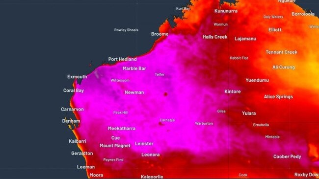
50C-plus possible in WA
Broome is expected to see between 34-35C every day for the next week. Website Weatherzone said a 50C temperature could be reached on Friday or Saturday in the Pilbara. In February, this has only been recorded once before when Mardie, 135km south of Karratha, reached 50.5C in 1998.
It will be sunny in Perth with a high of 26C on Thursday rising to 33C on Saturday and 34C on Sunday. Minimums will be in the mid-teens but will get as high as 20C on Monday morning.
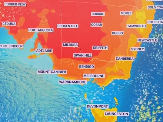
A low-intensity heatwave, with patches of severe heatwave, will then funnel through central South Australia and into the eastern states.
Low to Severe intensity heatwave conditions continue over inland WA. A Heatwave Warning is current. Heatwave conditions will be moving into parts of SE Aus from Thurs.
— Bureau of Meteorology, Australia (@BOM_au) February 15, 2023
Latest: https://t.co/vOm4XFkh6rpic.twitter.com/qdWT0mM64h
Adelaide could hit 38C on Thursday as that ribbon of heatwave passes north of the city. It should then cool on Friday and Saturday to the mid-twenties with 19C lows before rising again to 29C on Sunday and then as much as 35C next Wednesday.
Melbourne could nudge 40C
On both Thursday and Friday it’s likely to hit 35C in Melbourne with a low of 24C. There could be a thunderstorm on Friday.
But Sky’s Mr Sharpe has said that could be an underestimate.
“I actually think we’re going to be hitting the high thirties in Melbourne which is well above the Bureau’s forecast.”
For Saturday it should only get down to 22C and then 26C on Sunday.
Mildura could get up to 43C on Friday before dropping 10 degrees on Saturday, while Yarrawonga is forecast to get to 41C on Friday.
All of Tasmania could see a low-intensity heatwave from Wednesday until Friday with the conditions in Hobart continuing into the weekend.
Temperatures in the city are looking at 28-29C for Thursday and Friday before dropping to 24C on Saturday and then up again to 27C on Sunday. Minimums will be in the mid-teens. There could be a shower or two on Sunday.
Launceston should get as high as 33C on Friday.
Canberra is forecast to have 30C-plus days until Wednesday. A high of 31C on Thursday will creep up to 33C on Friday and then 34C on Saturday accompanied by a possible storm. Overnight lows should be 14C early on Friday and 16C first thing Saturday.
39C in parts of Sydney
Coastal winds should moderate the heatwave in Sydney’s CBD but Saturday could still reach 32C. Expect just below 30C to end the week with 20C at dawn. A thunderstorm is possible on Saturday ahead of the slight dip in temperature.
But the cooler maximums won’t get very far inland. Penrith, in the city’s west, will be uncomfortably hot for the next week. Thursday’s high of 33C will jump to 39C on Saturday. A drop to 31C on Sunday will lead into a 37C Monday.
The heatwave will spread across much of coastal southern NSW and northern NSW. Nowra will go from 31C on Thursday to 36C on Sunday, Tamworth will peak at 38C from Saturday to Tuesday and Bourke is facing a 42C Saturday.
Huge amounts of rain in northern Queensland
In Queensland, heatwave conditions will persist across southern border areas from Thursday into next week. Thargomindah is in a pattern of at least 40C days touching 43C on Monday.
Brisbane isn’t in the heatwave zone but will see a string of warm days nonetheless. For Queensland’s capital, it’s likely to be rinse and repeat weather for the coming week. Partly cloudy days will get to 30-31C with nights around 19-21C. No rain is in the forecast.
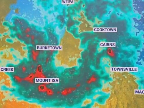
But rain is very much in the forecast for northern Queensland.
Cairns could see huge downfalls with 70-200mm possible on Thursday and up to 150mm on Friday and then lesser, but still hefty, falls over the weekend.
A tropical low is bouncing around the Gulf of Carpentaria which will deliver heavy falls for Burketown, Cooktown and Weipa.
Mostly dry in Darwin for the end of the week although afternoon thunderstorms could bring a few patches of rain. Temperatures will top out at 33C with 27C lows. Stormier weather could be in store for the Top End over the weekend.

Originally published as Australia weather: Every state and territory facing heatwave

200 species dead in ‘unprecedented’ disaster
Scientists have offered a grim outlook for Aussies hoping for an immediate solution to an ‘unprecedented’ disaster leaving the water at Aussie beaches toxic.

Australia told to brace for a soaking
Parts of Australia that have already experienced a wet weekend should expect more downpours in the week ahead.