
New maps: ‘What was protected before is no longer protected’
A koala conservation expert says the State Government’s new mapping model for koala habitat has ‘shocked and appalled’ those working to save remaining populations. She has a dire warning if the Government goes ahead with its current plans.
Moreton
Don't miss out on the headlines from Moreton. Followed categories will be added to My News.
A South East Queensland koala conservation expert has slammed the State Government’s future koala habitat mapping saying unless Government starts over koalas will be wiped out in some regions within five years.
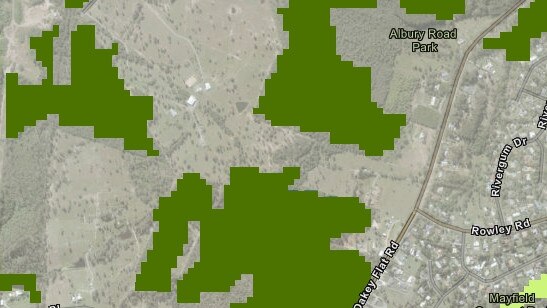
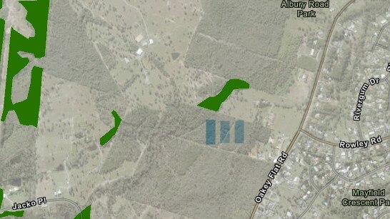
Koala Action Inc (KAI) president Vanda Grabowski said “it was clear from the new mapping model”, released to the public for consultation in December 2019, “that what was protected before is no longer protected”.
The State Government released the South East Queensland Koala Conservation Strategy before Christmas, public submissions have closed on the mapping but remain open until January 31 on the strategy.
A review of the mapping, by an expert who did not wish to be named, said across the entire SEQ some “mapping changes are legitimate where clearing has occurred but in other areas existing habitat values are no longer recognised in the proposed plan. This goes at odds with the messaging around the new draft plan.”
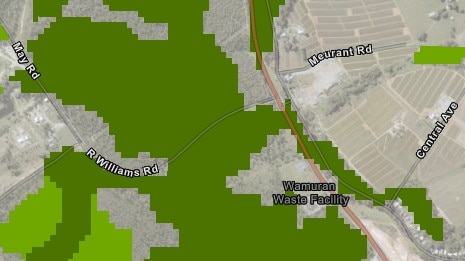
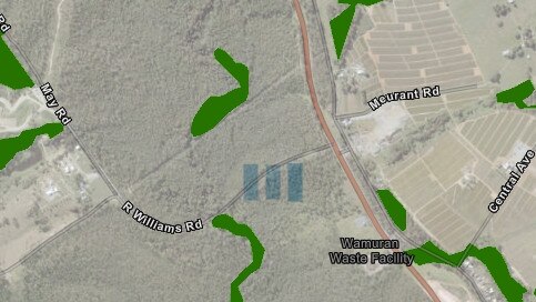
The expert said a comparison of mapping protections (2010 and 2019) in Morayfield and Wamuran alone showed significantly reduced koala habitat. The same losses could be seen across Redlands and Logan as well as in Caloundra, Mapleton and Springbrook.
“It seemed from review that most suburbs on average have lost some habitat mapping,” the expert said..
“I understand this has to do with restricting the new mapping to Herbarium mapping, old habitat mapping was less confined and mapped regrowth koala bushland much better, based on this ... I think it is highly unlikely there is a single suburb which has more habitat mapped.”
$1 for 28 days: Full digital subscription
MORE NEWS
Mapping exercise reveals errors
Large swathes of land protected under new plan
Councillor calls for greater koala protection
A Department of Environment and Science (DES) spokesman said “the draft new koala habitat mapping was released for public validation in December 2019, to remove any areas that had previously been developed.”.
“It is now in the process of being updated, and will be released to support the proposed new koala planning framework in the near future.”
But Ms Grabowski said the mapping, released in December, did not give organisations the capacity to create an accurate overview of the region as it only allowed people to access individual properties not the entire region.
Ms Grabowski also called for the Government to release data on the studies that have been done into the areas the Government intended to protect under the new mapping model and Strategy.
“There might be trees in these areas but where are the koalas. From the sightings and admissions to hospitals from these new protected areas the numbers just don’t show the populations,” she said.
“If they had factored in sightings and medical admissions they would know they have to protect the urban and peri-urban habitats.
“To protect koalas you have to protect the habitat on which they live. It’s common sense.”
Ms Grabowski said State Government must “scrap this and go back to the beginning” and go to the people “who know where the koalas are”.
“The mapping is crucial and it has to be correct,” she said.
“This makes no sense to those of us on the ground who have been rescuing them and rehabilitating them where DES says there are not koalas and no habitat … well they are having babies there.”
Ms Grabowski called for transparency on the mapping model and the recommendations of the Koala Advisory Council (KAC) to Government relating to urban and peri-urban habitats.
The Government’s KAC members include former RSPCA CEO Mark Townend, Dreamworld Life Sciences Division General Manager Al Mucci, Director of Australia Zoo Wildlife Hospital Rosemary Booth, forestry officials, local government advisers, Urban Development Institute of Australia representatives but Ms Grabowski said no “front line” conservation groups from anywhere across South East Queensland were on the KAC.
“We are shocked, horrified and appalled by this mapping because it is clearly inadequate in the Moreton Bay region,” she said.
“What is protected is areas in the western parts like Dayboro and Samsonvale where we have minimal to no koalas.”
The DES spokesman confirmed current koala population sightings in Dayboro stood at 52.
WWF Australia said it was waiting for the Queensland Government to provide WWF with mapping that “would allow our scientists to analyse the proposed changes and see if the maps follow the fundamental principle of no reduction in protection for known koala habitat”.
“We urge the Queensland government to be fully transparent regarding the mapping methodology and decision making process for including or excluding forests in the koala habitat maps.
“We also ask that the government share this critical mapping with key stakeholders as a matter of urgency.”
Ms Grabowski said conservation groups understood “it’s not going to be easy (to protect habitat in urban areas) but if they are fair dinkum about doing it (saving koalas)… it’s got to be where they are today and not where they might be or where they might be translocated to.”
She called on community to contact their “councillors, MPs and tell them I am willing to forgo something so koalas survive. It’s not always what is convenient for humans.”
“Humans have options. When things are tough there are people with food, water, shelter for them. Wildlife have nothing, once their food is gone, their shelter is gone, everything is gone …. They can’t even get to where it is better.”
The DES spokesman defended the mapping saying the koala habitat areas had been identified using state-of-the-art modelling, including two decades of koala sighting records, scientific research and existing mapping used by local councils, and regional ecosystems and high-value regrowth mapping provided by the Queensland Herbarium.
“Koala sighting records were sourced from government databases such as WildNet. Additional records were utilised from sources such as KoalaBase and the Atlas of Living Australia, as well as records provided by local governments,” he said.
“The records were filtered to remove old, imprecise, incorrect and duplicate records. Overall 80,594 koala sighting records were used in the development of the koala habitat model, which underpins the mapping.”
He said Moreton Bay Region sighting records reflected 20,198 sightings with “87 per cent of those from within areas identified as a Koala Priority Area”.
The News asked DES if existing protected koala habitats had been removed from the new draft mapping.
The spokesman said the new mapping identified “best quality koala habitat and is designed to focus the government’s conservation efforts on areas that have the greatest chance of supporting koala populations. This methodology was endorsed by the Koala Expert Panel.”
“The new mapping, and future planning amendments, will increase the area of koala habitat areas protected in Moreton Bay, and increase protections by prohibiting clearing of koala habitat areas within a Koala Priority Area.”
“The Queensland Government has invested $2 million in a new partnership with Queensland Trust for Nature which will work with landholders and local governments in delivering koala habitat restoration activities across South East Queensland.”
The spokesman said the KAC did not appoint representatives from “particular geographic areas” instead members had “an interest in koala conservation across South East Queensland as a whole.”
He said the draft Strategy identified 32 potential future actions including habitat protection, habitat restoration and improved mapping in existing urban koala populations in Caboolture and the Moreton Bay region.
“Many Queenslanders expressed a desire to ensure that their local areas of vegetation were protected under this new framework,” he said.
“Landholders will be able to apply to the Department of Environment and Science to make, amend or revoke koala habitat mapping on their land following the approved processes.”
The spokesman said following public consultation on the South East Queensland Conservation Strategy (closing January 31, 2020) feedback would be “analysed and used to inform the final Strategy which is expected to be released this year”.

Police hold ‘concerns’ for missing Qld teen
Police appealing for help to find a missing 16-year-old from Bundaberg, last seen at Caboolture.

Serial thief flees with lucky punter’s pokies winnings
A sticky fingered thief who used a fake bank statement to try and defraud businesses out of their hard earned cash has had the law catch up to him.