
Flash flooding, roads closed as big wet continues across South East
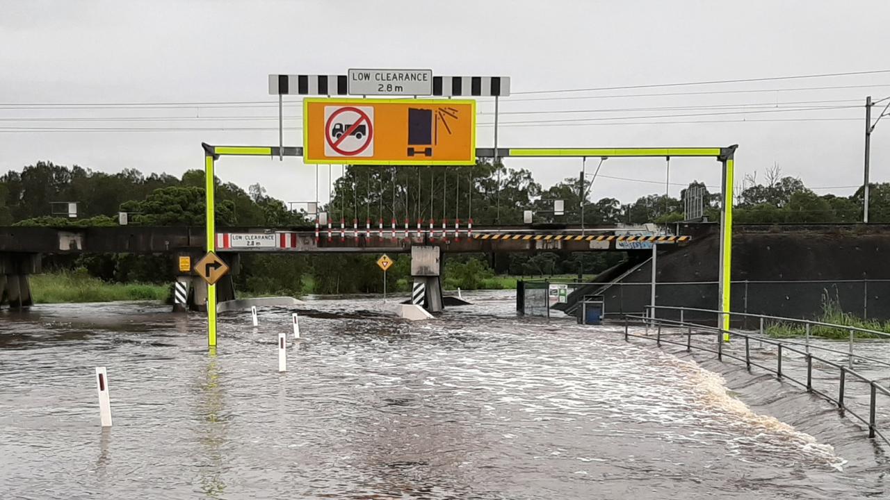
Flash flooding has forced the closure of several roads, while shopping centre car parks and yards have been inundated, as rain continues to tighten its grip across Greater Brisbane.
Moreton
Don't miss out on the headlines from Moreton. Followed categories will be added to My News.
Flash flooding has forced the closure of several roads, while sports fields, shopping centre car parks and yards have been inundated, and rivers and creeks continue to swell, as heavy rainfall tightens its grip across Greater Brisbane.
While a Severe Thunderstorm Warning for Southeast Queensland has been cancelled, the Bureau is forecasting showers including heavy falls to continue throughout the day, with the chance of a thunderstorm.
A flood watch also remains in place for South East Queensland catchments between Bundaberg and the NSW border, with the Pine and Caboolture Rivers, Upper Brisbane River,
Lower Brisbane River and Logan and Albert Rivers among those likely to be affected.
The Bureau said there is a continued risk of heavy rainfall and river level rises across the flood watch area, with showers and thunderstorms expected to continue through tomorrow, and localised heavy falls possibly continuing.
Scroll down to see our rolling coverage of what’s happening in the following regions: Albert and Logan, Redlands, Wynnum – Manly, Southside, South West, Southeast, Bribie Island, Redcliffe and Bayside, Pine Rivers and North Lakes, North West and Westside.
UPDATE: ALBERT AND LOGAN
Parts of Logan and Scenic Rim are in danger of major flooding later today.
The Bureau of Meteorology said major flooding was expected at Beaudesert this evening with further forecast rainfall.
Moderate flooding is expected at Wolfdene and Beenleigh tonight.
Rapid river level rises have been recorded and are continuing at many locations across the Logan and Albert river catchments.
In the 24 hours to 9am, moderate to heavy falls of up to 100-150 mm were recorded at Beenleigh and falls of 30mm to 50mm were recorded near North Tamborine.
The Logan River at Maclean Bridge is at 6.29 metres and the bureau said it expected minor flooding in that area.
Wolffdene near the bridge is also at 5.4m and rising.
The bridge was rebuilt after the 2017 floods in April.
The Albert River at Beenleigh is at 1.92m and likely to exceed the moderate flood level of 4.5m.
Residents of Beenleigh and those living at the mouth of the Logan River have been warned about the possibility of flash flooding today.
Waterford, Greenbank, Bahrs Scrub and Chambers Flats are where roads in Logan have the worst flooding this morning.
Nine roads have been closed across the city with some of the worst flooding in Waterford near the Larry Storey Bridge, where there was major flooding in April 2017.
Morning traffic to and from Waterford’s Canterbury College was held up with a service road near the school going under.
The Bureau of Meteorology said the Logan River at Waterford was a 1.7m at 8am and said further river rises were possible, as showers and storms and further heavy falls were forecast throughout the day.
Flashing “flooded road” signs were erected along River Rd, which runs along the Logan River and next to the Larry Storey Bridge.
Passers said they were amazed to see cars traversing the flooded road despite signs erected by the council late last week.
Nearby Pimpama St at Waterford was also flooded.
Flash flooding at Cedar Vale also cut off residents who said the local roads along the river were flooded.
The council said all nine closed roads would have to be inspected before any were reopened.
REDLANDS
A major link road between Brisbane and the Redlands remains partially flooded for the third day in a row, affecting thousands of commuters travelling between the two cities.
Redland City Councillor Paul Bishop has urged motorists to be extra careful today, with several roads affected by flash flooding across Division 10.
While visiting areas of concern this morning, Cr Bishop said main thoroughfare Rickertt Rd was particularly affected, along with Mary Pleasant Dr, Mary St, Pitt Rd, Byng Rd, Collingwood Rd.
“I’m currently on Rickertt Rd, and this is the third day where flooding has been delaying traffic and causing hazards for motorists.
“Yesterday I wrote to council officers and disaster management staff in Redland City Council and also Brisbane City Council … just requesting emergency flash flood warning lights to be installed before people get into this thoroughfare.
“This is the mid-morning peak hour traffic leading up to Brisbane from Redland City and cars coming in the opposite direction from Brisbane to Redland City are meeting hazards, buses, cars and motorcyclists and even cyclists having to ride through significant water.
“At night it’s very difficult to see, please do take care when you are travelling through this area.”
He said while upgrades to the Greencamp Rd intersection had been fantastic, other untouched stretches of the road were still especially hazardous during times of extreme rain and called for work to be done to improve safety.
Cr Bishop said the road had been closed to traffic about 8am due to the dangerous conditions.
Meantime, Redlands Coast Guard is warning boaties to keep a close eye on their vessels and moorings. With large rainfalls and the possibility of some effect from cyclone Uesi as it moves south out of the coast, the Coast Guard said conditions are ideal for issues to develop with moored and anchor vessels. If you find yourself needing assistance, you can call 3206 7777.
BAYSIDE: WYNNUM – MANLY
There are some parts of Brisbane’s bayside which have been hit by marginal flooding, but the main concern is for boaties travelling out into Moreton Bay.
Harvey Shore from the Brisbane Coast Guard Manly Flotilla said there are major concerns for boats going out past nearby islands.
“It’s extremely dangerous out there as there are ocean swells as you get past the bar,” Mr Shore said.
“Little vessels will just get taken over by these kinds of swells.
“Coast Guard flotillas up and down the coast have been helping pull in boats caught up in these swells which will continue over the weekend.”
Mr Shore said boaties within the bay need to beware of floating debris following the recent downpour.
“We’ve even had to pull half of a big tree into the harbour so people really need to be careful,” he said.
Residents have reported up to 100mm of rain in the bayside suburbs of Manly and Wynnum.
SOUTHSIDE
A photo of Capalaba Rugby League Club shows the field is completely inundated, after close to 100mm fell in the region in the past 24 hours.
While the water over Rocklea roads is slowly subsiding, local parks are still being inundated. Steph Dubignon snapped photos of Kookaburra Park flooded by local Stable Swamp Creek run-off. She said while there was a lot of water around today it was worse at the weekend.
“ Sunday was higher,” she said.
“It was over the road about knee deep.”
Major flooding has been reported in areas of Gumdale, Ransome and on Rickertt Rd past Greencamp Rd.
Rickertt Rd is closed at Ransome/Wakerley is closed between Greencamp Rd and Chelsea Rd.
The bridge on Ipswich Service Rd off Marshall Rd near Bunnings Rocklea is also flooded between Gilmour Place and Balham Rd, as water inundates the area.
Mt Gravatt-Capalaba Rd is also blocked between Tilley Rd and Moreton Bay Rd at Chandler due to flash flooding.
SOUTH WEST
Heavy rain always raises concerns for drivers at Oxley and in parts of Inala and Durack, where there are known flooding hot spots on low-lying roadways.
So far today, residents have a reprieve from major road flooding but reports on social media show there are still areas to reconsider when driving today:
Some water over the road along Englefield Rd this morning;
Some prolonged accumulation of water after heavy rain on the roundabout at Oxley Rd and Oxley Station Rd;
Some water accumulating on Blunder Rd, but not flooding; drivers have reported the road is clear since then.
In Durack: Bowhill Rd flooded this morning
In Inala: Some water temporarily over the road along Inala Ave
SOUTHEAST
63mm of rain was recorded in the gauge at Carindale in the 24 hours to 9am, while there were reports of the State High fields on Fursden Rd at Carina being under water.
It comes as the LNP council has been slammed for ignoring community concerns over pollution and flooding at the old Carina bakery.
Frasers Property is developing 197 units and 20 residential lots at the former Goodman Fielder Bakery site.
The 5.4ha site at 179-193 Fursden Rd is on a flood plain and adjoins Minnippi Parklands.
Labor candidate for Doboy Jo Culshaw said poor sediment control on site had seen massive amounts of mud and silt wash onto Fursden Road and ultimately, Bulimba Creek, following heavy rain this week.
Mrs Culshaw and concerned residents reported the issues to Brisbane City Council in January after heavy rain.
You can read the full story here.
BRIBIE ISLAND
Bribie Island Police reported no problems with the overnight rain but residents took to social media to post photos of flooded yards and car parks.
One resident said the island had 155mm since 6am yesterday.
Wendy Hedge said there was so much water in her back yard she now had a canal property.
Residents also reported Bribie Island Rd to Caboolture was open.
CABOOLTURE
Water was flowing over the road at William Berry Drive at Morayfield. The birds were also having a great time enjoying their much bigger swimming area at Centenary Lakes – with water spilling over the banks and onto the footpaths.
PINE RIVERS AND NORTH LAKES
Danzy Buchanan Park in Mango Hill is now more suitable for water aerobics than an outing with the dogs, while Lake Eden in North Lakes is slowly creeping up its steps with the water nearly reaching the walkway.
Don’t even try your luck at Maryvale Rd in Mango Hill for multiple warning signs await hopeful drivers. Steer clear.
Henry Road in Griffin is likewise impassable with a row of signs discouraging motorists.
And it would come as no surprise that Mott St in Strathpine has been given the closed down treatment with a good amount of water obscuring the low lying road.
NORTH WEST
The normally tranquil Kedron Brook swelled overnight and overflowed on to the Kedron Brook bikeway and even covered the footbridge across the waterway.
Gordon Park resident Bronwyn Jobson, who took these photos about 8.45am, said it was flowing “pretty fast” and would have been “a couple of foot” over the bridge.
“You had to walk round the road way to get to the bus station,” she said.
WESTSIDE
Pullenvale State School’s usual morning congestion was made even worse this morning after Grandview Rd was cut, with about 20cm of water over the road at one point.
Many parents were forced to park hundreds of metres away and walk.
A huge pothole opened up on the left lane of Mt Crosby Rd, outbound, near Bunya St, which was difficult to see due to the rain and as it had filled with water.
Some residents were concerned there could be a serious accident if a motorbike rider hit it.
There were also reports of some water over Moggill Rd at the low point near the Pullenvale IGA supermarket.
Several The Gap residents with rain gauges said they had recorded nearly 350mm since last week and residents James Bristow said his total since the start of the year had now passed the 500ml mark.
Gap Creek Rd was cut overnight and this morning due to steady falls over the past 12 hours.
Boscombe Rd in Pullenvale was also cut.
Although westside creeks including Cubberla, Ithaca and Enoggera creeks were swollen, no footpaths or roads were cut as a result.
Traffic was unusually heavy on the main westside arterials, including Moggill Rd, the Western Fwy and Waterworks Rd.

Outcry as council secretly endorses plans for controversial port upgrade
Redland City Council has secretly endorsed revised plans for the Toondah Harbour port, with the drastically different proposal now awaiting state approval.
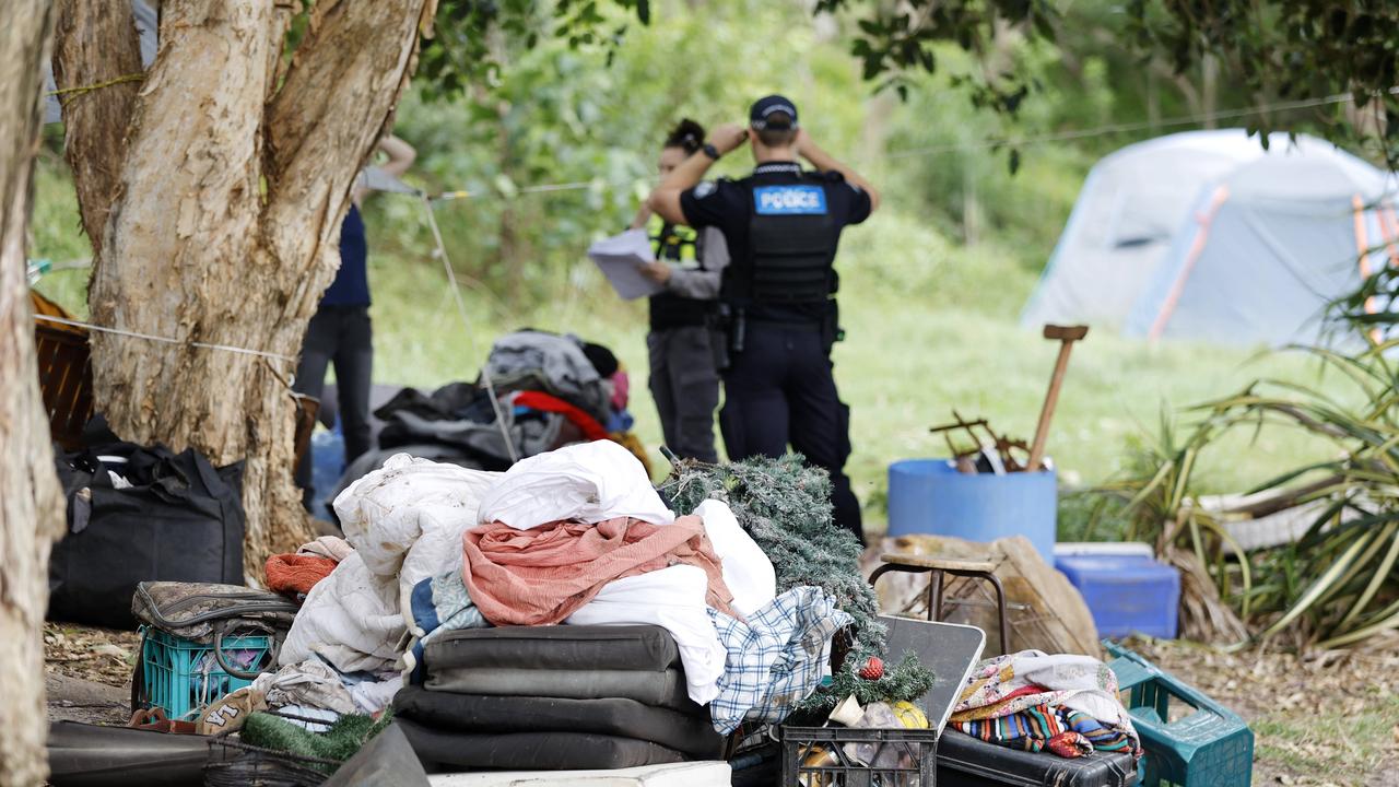
‘My only safe place’: Emotional scenes as homeless evicted
A woman “hiding” from a domestic violence perpetrator was one of several residents evicted from a Moreton Bay homeless camp on Monday, after a review raised serious health concerns.