20 incredible before and after aerials: SEQ’s flooding disaster laid bare
Aerial views from across southeast Queensland show a sea of brown ruin as communities fight back from floods. Check out our interactive before-and-after photo sliders.
When up to 1500mm of rain falls in the space of three days, the result is guaranteed to be dramatic.
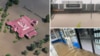
Nearmap captured the following before and after images via the Nearmap proprietary aerial camera system attached to planes.
They show vast areas of Logan and inner Brisbane under a lake of brown water, carparks and vanished beneath the swollen rivers and creeks.
Some of the most dramatic images were around Bethania and Waterford in Logan where homes were surrounded by green lawns and fields in January. This week, they were unrecognisable.
Riverfront suburbs including Albion and South Brisbane were also transformed, with pontoons, walkways and roads buried under water.
Nearmap aims to capture aerial imagery following every major natural disaster in Australia that has a significant impact on property, infrastructure, and communities.
Nearmap ImpactResponse combines the firm’s leading aerial imagery, location intelligence and geospatial tools so businesses in sectors including government, insurance, and property have access to current information on the ground following natural disasters, at a time when ground access is limited, and inspection resources are stretched.
Albion’s riverfront streets and buildings taken over by the River.
Roads were cut and a pontoon disappeared at Albion.
Now you see it, now you don’t. This Beenleigh carpark vanished.
Beenleigh houses became isolated islands.
Bethania in Logan turned into a brown lake.
Vast areas of Bethania went under.
Roads across Bowen Hillls were cut.
A massive murky lake formed in Corinda.
Tennis courts were submerged in East Brisbane.
This Goodna park became a swamp.
A waterfall emerged from what was once dust at Grantham.
Parts of Loganholme became a waterway.
Roads and carparks disappeared at Oxley.
A vast inland sea formed at Riverhills.
The river swallowed this pontoon at South Brisbane.
A Waterford dam became a lake.
These Waterford homes suddenly became waterfront homes.
Huge flooding at Waterford West.
Photos by NearMaps