
The Aussie suburbs most at risk from climate change
A staggering $25 billion worth of property in Australia is ‘at very high risk’ from rising sea levels and coastal erosion. These are the Queensland suburbs in the firing line.

Property
Don't miss out on the headlines from Property. Followed categories will be added to My News.
A staggering $1 trillion worth of property in Australia is ‘at risk’ from rising sea levels and coastal erosion, and Queensland is in the firing line.
And of that, $25 billion of ‘very high risk’ real estate nationally could be impacted within 30 years, according to CoreLogic’s Coastal Risk Scores for Financial Risk Assessment March 2022 whitepaper.
The report, which looked at the risks associated with storm surges, coastal erosion and rising sea levels, estimated that $5.3 billion worth of properties were considered “very high risk” nationally, while a further $19.5 billion worth of property was deemed “high risk”.
Queensland had the highest number of properties (311,148) located within 1km of the coastline, with an estimated combined value of $218.4 billion.
MORE NEWS: Housing affordability plummets to 75-year low
Labor extends helping hand to first-home buyers in regional Australia
Old house on double block sells for $21.5m at Sunshine Beach

However, NSW had the highest combined residential value of property within 1km, a staggering $423.2 billion.
CoreLogic’s head of consulting and risk management Dr Pierre Wiart said the damage caused by recent weather events in southeast Queensland and NSW were a tragic but timely reminder of the devastation that extreme weather events could have on people and property.
He said the Coastal Risk Score would inform homeowners, future buyers and financial services sectors, such as insurers and lenders, of potential future climate-related coastal risks.
“In the next three decades, coastal risk will crystallise, with the tangible effects of climate change already being felt in most parts of Australia,” Dr Wiart said.
“Coastal risk has far-reaching implications for the country’s property market and its supporting financial sector, including property valuations, home loan viability and insurance premiums.”
The report said that while coastal risk concerned a relatively narrow distance from
the coast, it was also an area where a lot of residential wealth and high-density living was concentrated.
In Queensland, the biggest pool of vulnerable residential wealth was in the southeast corner, but risks were also identified in the regions.
The report said the past two years had seen an influx of money pouring in to property markets like the Gold Coast and Sunshine Coast, driving up median values by 33 per cent and 34.4 per cent respectively.

Extensive analysis of property sales, geography, topography and hazard data has led to the creation of coastal risk categories for every vulnerable suburb on Australia’s coastline, from low risk to very high risk.
“While storm surges present an immediate risk to coastal properties, the effects of gradual coastal erosion over time can also be significant,” Dr Wiart said, with the report analysing shoreline movements from 1988 to 2019 to calculate a retreat rate for each individual property.
East Mackay was found to be the most vulnerable to erosion, with an average property distance from the coast of 424m and a coastline retreat of about 7.72m a year, according to the report.
Kinka Beach (Livingstone) had the second highest rate of retreat at 7.25m, with an average coastal distance of 358m.
Other Queensland suburbs to make the top 20 national list of suburbs with the highest retreat rates included Deepwater (Gladstone), Amity (Redland), Cungulla (Townsville), Airdmillan and Jarvisfield (Burdekin).
Locations most at risk were also located in Victoria, NSW, South Australia, Western Australia and Tasmania.
Four and out the top 10 ‘very high’ or ‘high’ risk suburbs for combined residential value were in Queensland, with Paradise Point on the Gold Coast leading the list with $1.47 billion of property considered vulnerable.
Runaway Bay, Caloundra and Golden Beach also made the national top 10.
“Paradise Point has the highest concentration of detached houses most vulnerable,” the report said. “As a consequence of their high retail value, estimated at $1.47 billion within 6.4sq km, no other suburb (nationally) has such a high concentration of residential wealth subject to high coastal risk.
“About 20 per cent of the suburb is at high risk, equivalent to 40 per cent of the suburb’s total residential value.”
Seven apartment buildings at Noosa Heads were also identified among Queensland top five suburbs deemed at risk.
Noosa Heads, and much of the Sunshine Coast, has been a magnet for cashed-up interstate buyers during the pandemic, leading to soaring prices.

In NSW, the most at-risk areas by combined value were Cronulla, Manly, Collaroy, Ettalong Beach and Wamberal, while in Victoria they were Port Melbourne, Aspendale, Brighton, Middle Park and Williamstown.
Elsewhere, topping the list in other states were Mindarie (WA), Glenelg North (SA) and Sandy Bay (Tasmania).
“Unsurprisingly, Queensland’s vast coastal hot spots, and significant rise in median values in the past five years, puts it at the top of Australia’s most vulnerable states for coastal damage,” Dr Wiart said.
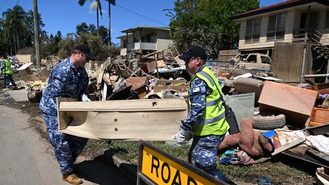
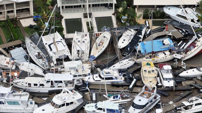
The report comes a month after a deadly rainbomb led to widespread floods across southeast Queensland and NSW, with the estimated damage bill across both states closing in on $2.5 billion, according to the Insurance Council of Australia (ICA).
A recent survey by ICA revealed that two thirds of those living in communities impacted by the floods did not believe governments were investing enough to protect homes and communities from extreme weather events.
An overwhelming 94 per cent of people surveyed say there should be better controls on where homes are built so they are not at risk of flood.
Alarmingly, 37 per cent of those surveyed said they did not have enough insurance to rebuild if required.
Earlier this month, MCG Quantity Surveyors director Marty Sadlier said homeowners affected by the recent floods could be underinsured by “hundreds of thousands” of dollars after median values and construction costs soared.

Revealed: Shock rental finds driving property managers to quit
Stumbling on surprise adult toys to brushing against poo-smeared walls are among shock rental nightmares driving a third of property managers to quit.
Lockyer Valley’s unique business opportunity
A unique business opportunity has sat idly on the market waiting for the right buyer to show up at its doors. Here’s why it’s the perfect next business venture.