
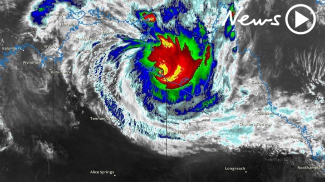
Townsville in ‘target zone’ for potential Tropical Cyclone Gretel
A leading Australian meteorologist has revealed Townsville has the six key ingredients for a tropical low to strengthen into Tropical Cyclone Gretel next week. FULL FORECAST >>
Townsville
Don't miss out on the headlines from Townsville. Followed categories will be added to My News.
Brewing conditions are perfect for a tropical cyclone to form over the next week, with weather models showing it could swing by Townsville.
Sky Weather chief meteorologist Tom Saunders said all six requirements for a tropical cyclone to form looked to become apparent late next week.
Tropical cyclones need warm sea surface temperatures, atmospheric instability, high humidity in the troposphere, enough Coriolis force to develop a low-pressure centre, a pre-existing low-level focus or disturbance, and low vertical wind shear.
“They will all be present next week. Most of our models have been hinting towards (a cyclone forming) in the second half of next week,” Mr Saunders said.
“Townsville is definitely in the target zone.”
Mr Saunders explained sea surface temperatures were perfect for a cyclone.
“Ocean temperatures are much warmer, 2C warmer than usual,” he said. “It’s over 30C right now, that’s more than 3C above the threshold for a tropical cyclone.”
Mr Saunders said a pulse of the Madden – Julian Oscillation was predicted to strengthen. The Bureau of Meteorology explained an MJO pulse at this time of year typically leads to above average cloudiness and rainfall in parts of Northern Australia.
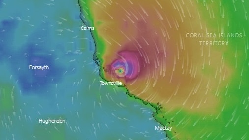
If a tropical cyclone does form it will be called TC Gretel.
The European Centre for Medium-Range Weather Forecast shows Gretel could potentially form north of Cairns on Friday, March 13, before barrelling down to the Townsville coast by the end of the day.
Mr Saunders said people in Townsville should expect more storms at the weekend, following the spectacular lighting show early Friday morning.
“The trigger for the storms is still over the inland, what that means is there is a high chance of storms again,” he said.
Mr Saunders said some of these storms could result in heavy rainfall and possible flash flooding events.
He most of Townsville got between 10mm to 15mm of rain overnight leading to Friday morning.
“Stuart Creek got 47mm, that was the top rainfall in Townsville,” he said.
Temperatures in Townsville over the next week are expected to be in the low 30s, with a high chance of rain.
Official forecast
Monday: High chance of showers; possible thunderstorm. 4 to 10mm of rain.
Tuesday: High chance of showers; possible thunderstorm. 6 to 20mm of rain.
Wednesday: High chance of showers; chance of thunderstorm. 15 to 40mm of rain.
Thursday: High chance of showers; chance of thunderstorm. 10 to 70mm of rain.
Originally published as Townsville in ‘target zone’ for potential Tropical Cyclone Gretel

Push to expand city’s hardship grants hits state roadblock
A push to extend hardship grants across Townsville has been met with a cautious response from the federal government, with the Finance Minister insisting the state must request it.

Council’s complaint policies tighten as Troy Thompson continues attacks
Email filters and escalating threats to police are some of the solutions council’s legal team has amid an influx of serial complainers hampering their resources. It comes as suspended mayor Troy Thompson continues his online attacks on council.