
Cyclone Jasper forecast: Far North Queensland in firing line as BOM updates tracking map
Cyclone Jasper forecast: Far North Queensland in firing line, but Townsville to be impacted by storm tide and damaging winds as BOM updates its tracking map. Read the latest forecast.
Townsville
Don't miss out on the headlines from Townsville. Followed categories will be added to My News.
Tropical Cyclone Jasper is on a collision course with the Far North Queensland coast after the Bureau of Meteorology issued a Tropical Cyclone Watch on Sunday for areas between Cape Melville to Townsville, including Cairns and Cooktown.
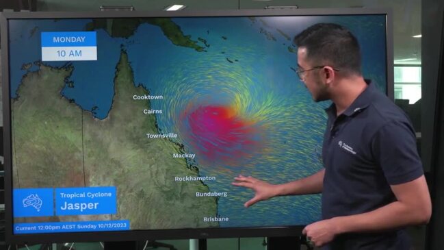
In its latest update at 4.54am on Monday, the BOM said TC Jasper had weakened to a category 1 cyclone, sustaining winds near the centre of 85 kilometres per hour, with wind gusts to 120 kilometres per hour.
Despite the weakening, Townsville has been warned about damaging winds and a storm tide, bringing large waves that may produce minor foreshore flooding.
TC Jasper was estimated to be 600 kilometres east of Cairns and 530 kilometres east northeast of Townsville, moving west at 20 kilometres per hour.
“(Jasper) may weaken slightly further during Monday as it tracks in a general westwards direction,” the BOM said.
“Jasper is forecast to re-intensify during Tuesday as it approaches the coast.
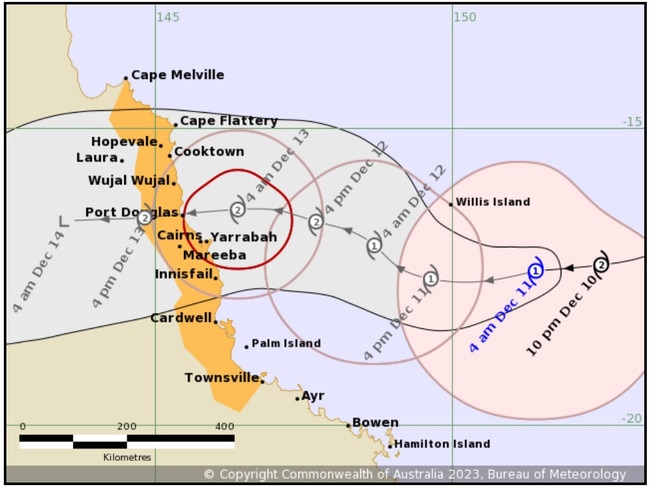
“The system is now forecast to cross as a category 2 system as it makes landfall during Wednesday, most likely between Cape Flattery and Cardwell.
“Jasper will weaken as it moves inland during Thursday towards the Gulf of Carpentaria.”
If the system was slower and crossed overnight Wednesday or Thursday, the BOM said a slim chance remains of a severe category 3 crossing.
Damaging winds of 90 km/h were expected to develop along the Queensland coast between Cooktown and Cardwell, including Cairns from Tuesday.
They may extend as far south as Townsville or as far north as Cape Melville depending on the movement of Jasper.
“A separate severe weather warning is current for damaging winds for the coast between Ayr and Mackay,” the BOM said.
âš ï¸Severe Weather #Warning update: area expanded south to Mackay. Possible damaging wind gusts on Monday. Details and updates: https://t.co/FBmpsInT9opic.twitter.com/tNKngDCRPC
— Bureau of Meteorology, Queensland (@BOM_Qld) December 10, 2023
“Heavy rainfall is expected to develop along the coast from late Tuesday, extending inland during Wednesday. A flood watch is current for the North Tropical Coast, parts of the Cape York Peninsula and Gulf Country.
“As the cyclone approaches the coast, a storm tide is expected between Cooktown and Townsville.
“Large waves may produce minor flooding along the foreshore. People living in areas likely to be affected by this flooding should take measures to protect their property as much as possible and be prepared to help their neighbours.”
People between Cape Melville and Townsville, including Cairns and Cooktown, should consider what action they will need to take if the cyclone threat increases.
The BOM’s next cyclone advice will be issued by 11.00am on Monday.
EARLIER:
‘Stay calm, but stay alert’ is the message from Townsville’s Local Disaster Management Group as the northeast coast of Queensland begins final preparations before tropical cyclone Jasper is expected to make landfall.
TLDMG deputy chair Kurt Rehbein advised Townsville that the incoming cyclone was expected to make landfall midway through the week.
“For Townsville, that means that it gives us a weekend for our communities to get prepared for whatever may come our way,” Cr Rehbein said.
“The advice is that over this weekend, it’s expected to reduce in intensity, but there is a chance that it can increase in intensity as it heads towards the coast.
At 10am AEST Saturday, Severe Tropical Cyclone Jasper (Category 4) with central pressure 950 hPa was located near latitude 15.4 south longitude 156.0 east, which is about 650km east of Willis Island and 1110 km east of Cairns.
“The system is moving southwest at 6 kilometres per hour,” the Bureau’s 11am Saturday update said.
“Severe Tropical Cyclone Jasper remains Category 4 in the Coral Sea and is tracking slowly southwest. Jasper is forecast to weaken to Category 2 over the weekend as it begins to track west.”
Jasper is forecast to cross the far north Queensland coast on about Wednesday.
“The highest risk of a cyclone impact lies between about Cape Melville and Townsville, including Cairns and Cooktown. As Jasper approaches the coast there is a risk of re-intensification and the potential for severe impacts.”
The Bureau says there is a moderate chance that Jasper would redevelop in the Gulf of Carpentaria by next Friday or Saturday.
🌀Latest track map for Severe TC Jasper. Severe Tropical Cyclone Jasper remains at Category 4 and is slowly heading southwards over the northeast Coral Sea. https://t.co/abjo0qiR5Xpic.twitter.com/LS1HsqQ2hw
— Bureau of Meteorology, Queensland (@BOM_Qld) December 8, 2023
Cr Rehbein advised the community to stay glued to the Townsville City Council disaster dashboard over the next few days as the system continues to develop.
“It’s important that you get your emergency kit ready and that you have an emergency plan in place. Take a look around at what you might need to do for your home, for your family, for your kids and your pets,” Cr Rehbein said.
“If you’ve got an old home, you might want to shelter in a more modern home — medications are a big one as well, every family is going to be different in preparations.
“That’s why we’re asking people to really think about it, have a talk with each other about what you’re going to do, what medications you may need, what food, what you might need to do for maintenance and what things you might need to move inside your shed before they become projectiles.
“If a cyclone comes our way, these are the sorts of things we need to get in order.”
Bureau of Meteorology image of Tropical Cyclone Jasper that his currently heading towards the Queensland coastline Picture BOM
While the exact trajectory that Jasper will take and whether it will maintain the current intensity is not clear, Cr Rehbein said considerations around sandbags and cyclone shelters being made available, but all options were on the table.
“With regards to whatever effects Jasper may have on the community, that will be dependent on what the advice is coming into next week,” Cr Rehbein said.
“So of course, if there is any hint of any sort of heavy rains or flooding and so forth, yes, the council will be taking steps towards supporting our community in that regard as well.”
Queensland Police Service Acting Superintendent Dean Cavanaugh said the community should remain calm as the news develops.
“No one should be concerned or alarmed at all with the information they’ve been receiving, please just take it as an opportunity to be prepared,” Sup. Cavanaugh said.
“Make sure you’re prepared and have that chat over the fence with your neighbour and make sure everyone’s safe. I’ve never spoken to anyone post-event who said they thought they had over-prepared.”
“Although we are hoping for the best, the threat posed by severe weather is real and people need to be prepared for its possible effects,” Acting Minister for the Queensland Reconstruction Authority Meghan Scanlon said.
“We are ready to support communities should Tropical Cyclone Jasper cross the coast.”
Ms Scanlon urged all Queenslanders to “get ready now”.
“Understand your local risk, prepare a household emergency plan if the worst happens and pack an emergency kit.”
QRA CEO Major General (ret.) Jake Ellwood said it was working with North Queensland councils and Local Disaster Management Groups.
“I encourage everyone to get ready by having their emergency plan in place and their emergency kit packed, and if you’re on the roads remember – If it’s flooded forget it.
“We know from past experience that communities that are prepared are more resilient and recover better from the impacts of severe weather.”
NBN puts in work to create stable network
Preparations are underway to ensure North Queensland’s digital backbone, the National Broadband Network (nbn), continues to provide fast, reliable internet to homes, despite the potential impact of Tropical Cyclone Japer.
During emergencies, most nbn service disruptions are caused by power blackouts / outages.
NBN Co, the government-owned corporation which operates the nbn, has been speaking regularly with the Bureau of Meteorology and other Government agencies at all levels relating to the cyclone threat.
The nbn’s field crews have been preparing and checking several Temporary Network Infrastructure assets for deployment if necessary.
These assets will allow nbn to quickly restore services to customers when a network is damaged.
In the event of an extended loss of mains power, there are generators on standby in Townsville, Cairns, and Mackay that can provide power to nbn infrastructure.
Satellite Phones, and Satellite Fly Away Kits that can provide emergency communications to the community or emergency services personnel, will also be made available in Townsville, Rockhampton, Mackay, and Cairns.
Checks have also been carried out on the Strengthening Telecommunications Against Natural Disasters (STAND) program, where Disaster Satellite Services utilise nbn’s Sky Muster satellite service to access a backup connection during an emergency event.
Head of nbn local queensland Kylie Lindsay said nobody wants to lose connectivity during a natural or other disaster.
“We are well prepared when it comes to portable technology solutions to restore connectivity and have assets pre-positioned across Queensland to keep locals connected if disaster strikes,” Ms Lindsay said.
“Our highest priority is to maintain and restore the nbn network and ensure communities remain connected – especially with emergency services.”
‘Get your cyclone kits ready now’
Queenslanders are urged to ensure their cyclone kits are ready to go, which includes power banks, portable phone chargers, batteries, torches, raincoats, enough water to last three days in case supply is cut (10L per person), non-perishable food, first aid kit and medicines.
Hinchinbrook Mayor Ramon Jayo said in addition to being aware of any potential threat, residents should take the opportunity to ensure emergency plans were in place and to clean debris from their properties that had the potential to act as “a flying missile in high winds”.
“Have a look at your emergency action plans and make sure that you are ready to go if push does come to shove – that your pantry is fully stocked, that your car is all fuelled up, that your batteries are ready to go.”
He said information on formulating action plans, what to stock in emergency kits as well as other key advice was located on the Disaster Dashboard.
Cr Jayo, speaking generally, said the prevailing advice for any cyclone was to “stay in place” in your homes.
“However, if you don’t feel that your house could potentially withstand cyclonic winds, if you don’t feel comfortable staying at home, the best thing is to go to your friends, neighbours or relatives who do.”
He said in the worst-case scenario, the council would open its cyclone shelter if a category-three cyclone was bearing directly down on Hinchinbrook.
Cr Jayo said there were strict protocols in place should the shelter become an option, including seating, bring your own food and water in a single backpack and the banning of pets.
“Make sure you follow your preparedness plan, and make sure you have everything in order.”
Cairns / FNQ
If a cyclone is developing, the Cairns Disaster Group will keep residents informed via the Cairns Disaster Dashboard, and the Cairns Disaster Centre Facebook page.
Residents can also register to receive text messages from the Cairns Alert emergency messaging system.
Townsville
The Townsville Local Disaster Management Group will keep residents informed via the Townsville Disaster Dashboard.
Residents can also subscribe to receive important emergency communication updates via email and text message here.
Hinchinbrook
If a cyclone is developing, the Hinchinbrook Disaster Group will keep residents informed via the Hinchinbrook Disaster Dashboard.
Mackay & Whitsundays
Mackay region residents can get the most up to date information from the Mackay Regional Council Emergency Dashboard where you can also opt-in for important notifications.
For Whitsunday coast residents, visit the Whitsunday Regional Council’s Disaster Dashboard for the latest updates and tips to stay safe.
Rockhampton
During a cyclone, residents can keep up to date via the Rockhampton Regional Council’s Emergency Dashboard or phone the local disaster co-ordination centre on 1300 652 659 for assistance.
More Coverage

Originally published as Cyclone Jasper forecast: Far North Queensland in firing line as BOM updates tracking map
Join the conversation

Deaths, tragedies and heartbreaks that rocked Qld this year
Queensland has experienced a string a of heartbreaking tragedies in 2025.
Read more

‘They should be given bravery awards’: Union boss’ claim after shooting
QPS is working with the family of a teenager who was shot by officers in Townsville as more details about the incident emerge. LATEST
Read more