Storms predicted to head west after 150mm lashing across parts of the Darling Downs
The wider Darling Downs hasn’t quite escaped the clutches of the backlash from Ex-Tropical Cyclone Alfred with the region set to receive up to 150mm in the next 24 hours, before settings its sights on the west. Here’s the latest.
The backlash of intensive rainfall and flash flooding brought on by Ex-Tropical Cyclone Alfred is set ease across parts of South East Queensland, turning its attention towards western Queensland.
A severe thunderstorm for the Darling Downs and Granite Belt was issued by the Bureau of Meteorology on Monday and could affect areas as far south as Goondiwindi.
Senior meteorologist Jonathan How said there’s still a risk for intensive falls in the warning area which could see six-hourly totals up to 120mm and 150mm in the next 24-hours.
“This morning we are already seeing some very dangerous thunderstorms developing to the northeast of Toowoomba right now, so the message today is that the environment is still very primed for severe thunderstorms and heavy rainfall,” he said.
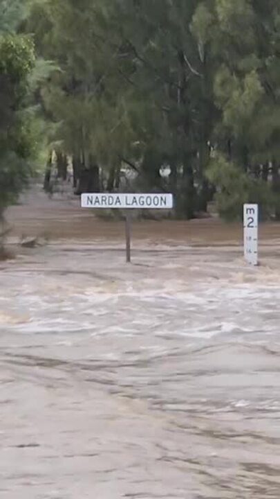
Mr How said the continued intensive falls could lead to dangerous flash flooding, with warnings already in place for the Lockyer Valley.
Rainfall in the eastern Darling Downs region is set to ease from tonight Mr How said, however there is still a chance those thunderstorms will continue to loom into the evening.

“We will see some thunderstorms out towards the western parts looking out towards Condamine and St George tomorrow and anything east of that looks to be showers,” he said.
“On Wednesday the storms look to be west of Bollon towards Cunnamulla and that will mean a chance to dry out for the eastern Darling Downs.”
East of Warwick copped a lashing overnight with Upper Emu Creek recording the highest rainfall of 157mm followed by Queen Mary Falls which received 155mm and Spicers Peak which recorded 139mm.
Across other parts of the southwest Warwick recorded 35mm, while Goondiwindi saw 36mm and between 10-15mm was recorded in Dalby.
Mr How encourages residents to keep an eye out for warnings issued by the Bureau of Meteorology.
EMERGENCY SERVICES ON HIGH ALERT
It was a busy weekend for emergency services and volunteers across Darling Downs and Lockyer Valley with hundreds of calls for help.
South West SES incident controller Dave Bennett said they responded to up to 500 events across the weekend including fallen trees and flooding.
“We just had the normal jobs that come with a rain event such as trees coming down, sandbagging and things like that,” he said.
“It wasn’t much different from a normal weather event, but the wind was incredible which didn’t help with the trees coming down.
“Across the region we probably attended 500 jobs, the biggest ones were trees falling onto houses which caused a fair bit of damage.
“We did a lot of prep work with the sandbagging and that was a really good outcome for us, with the community being so prepared it really helped the response phase of the operation.”
Mr Bennett said the south had taken the brunt of the storm while the west remained largely untouched.
“At this stage Toowoomba and the Lockyer Valley are the worst affected, but we are also watching the creek systems in other locations such as the Southern Downs,” he said.
“We only had one call out in the Western Downs and that was a pre-emptive sandbagging job, we’ve had nothing out to the West of us.
“At this stage we are only really concerned for the Lockyer Valley, especially with the rising flood water situation they have there at the moment and with the Warrego Highway being covered it impedes access for any emergency services.”
Mr Bennett said while the worst of Cyclone Alfred has passed he urged South West residence to remain vigilant.
“Maintain your situational awareness, keep an eye on the dashboard from each of the local governments, adhere to the warning the BOM is putting out and don’t drive through flooded water.”