
‘Unseasonable’: Wet weather could see falls of up to 100mm
Triple-figure rainfalls could be on the cards for parts of Queensland, with predictions for another ‘unseasonal’ rain event this week.
QLD weather news
Don't miss out on the headlines from QLD weather news. Followed categories will be added to My News.
South East Queensland could experience a significant rain event next week bringing the chance of gale force winds and dangerous surf conditions.
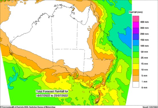
The Bureau of Meteorology says it’s not ruling out double or triple digit rainfall totals, with an upper trough expected to “amplify” over the state.
While it’s still not certain as to where the rain will hit exactly, meteorologist Shane Kennedy said some areas could potentially see tops of 100mm from Wednesday onwards.
“It (the rain) will start on Wednesday mainly in central Queensland, with isolated falls of less than 10mm. And showers around the South East will only be at that 1mm mark,” he said.
Moving through to Thursday, isolated falls in the central coast and central highlands could potentially reach 100mm but are more likely to stick in the 10 to 50mm range, according to Mr Kennedy.
The South East then could also see some showers in the 5-20mm range on Thursday and again in the 10-20mm range on Friday.
“It’s unlikely to be heavy rainfall, but certainly unseasonal. Thursday and Friday are set to be the bigger days,” he said.
The rain then should hang around slightly on Saturday before clearing up on Sunday.
WHAT’S BEHIND THE RAIN EVENT?
An upper trough is behind the forecast wet weather and BOM senior meteorologist Kima Wong said if the trough develops on shore the Central Coast and South East would likely be most affected.
“Rainfall will likely increase from next Wednesday, particularly for coastal areas,” she said.
“At this stage it’s looking like more steady, persistent showers rather than a big dump, particularly in the South East. But the focus does look more towards the Central Coast south of Townsville rather than the lower South East.
“Most of the accumulation will end up in places where moisture usually is like the tropics but I wouldn't be totally surprised to see higher double digits and maybe triple digits if it does set itself up the ways it looking.”
Ms Wong said strong winds would increase along the coast and depending on the trough’s development, may create gale force conditions.
“What we do know for sure is winds along the coast will increase, resulting in an increase in surf conditions,” she said.
“That’s affecting all of the southeast but again, it’s hard to know it’s impact. I wouldn’t rule out the risk of gale winds depending on how this trough and possible low develops.”
As for exactly how much rainfall would end up lashing the state next week, Ms Wong said the Bureau is hoping to know by Monday.
“At this stage it’s still a bit of a question mark, as is always with a long-term forecast,” she said.
“The next few days we’ll see reasonably fine conditions with some cloud cover over the coastal fringe and perhaps a light shower, particularly tomorrow and on Tuesday.
“From the middle of next week it’s more of a complicated picture, we will see an increase in wet weather next week in the southern tropical area but it’s still high uncertainty at this point.
“Hopefully we’ll have a better idea by Monday.”

Storm shield: How AI will protect our state of disaster
Queensland has secured world-first AI storm detection technology in a $3m partnership between Suncorp and the state government to revolutionise natural disaster response.
Read more

Hail, rain, wind, SNOW: Winter storm on Qld collision course
A rare winter storm threatens to dump 15cm of snow on Queensland's Granite Belt this weekend as forecasters warn of an incoming polar air mass.
Read more