
Weather watchers track monster storm off Queensland coast that could become tropical cyclone
Cyclone watchers are keeping a keen eye on a storm forming off the Queensland coast with BOM saying there is a chance it could develop into a freak tropical cyclone.

QLD weather news
Don't miss out on the headlines from QLD weather news. Followed categories will be added to My News.
Cyclone watchers are tracking a monster storm off the Queensland coast which has the chance of developing into a freak tropical cyclone.
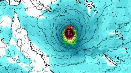
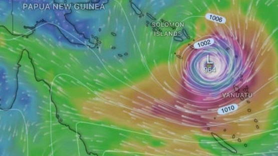
Bureau of Meteorology senior meteorologist Harry Clark said on Tuesday there was a “certainly unusual” chance of a tropical low forming in the Coral Sea over the next seven days, weeks ahead of the typical start of cyclone season in November.
“That system is rated as a low chance of forming a tropical cyclone over the weekend – around a 5-15 per cent chance – but by Tuesday, it does increase to a moderate chance as it moves a little bit more southwest,” he said.
“So, moderate being 25 per cent, the most likely outcome is that won‘t form a tropical cyclone, but still for this time of year that’s certainly fairly remarkable.”
While there is no threat to the Queensland coast, Mr Clark said the Bureau would continue to monitor the system over the coming days and into next week as a number of climate drivers bring what could be the first recorded cyclone in the Coral Sea for this time of year.
“It is certainly unusual for you to get one in the Coral Sea, it would be the first time we've actually seen one in October there since we began getting reliable records in the 70s,” he said.
“There’s a confluence of tropical climate drivers causing it … there’s the Equatorial Rossby wave which is basically an enhanced area of rising air in the air that can help trigger it.
“There‘s also a weak Madden Julian Oscillation pulses in the area that have just led to a bit of a favourable environment in an atypical time of year for development.”
Despite the early possibility of a cyclone developing, Mr Clark said El Nino would likely mean fewer cyclones, with the east of Australia having a 76 per cent chance of having less tropical cyclones than average.
“That is the general theme with El Nino, which is ironic I appreciate … but we really encourage everyone to use this as a good opportunity to become familiar with the seven day tropical cyclone outlook … and obviously make their preparations ahead of the cyclone season.”

Cold and wet … but will it snow in Qld this weekend?
Queensland is bracing for a blistering cold snap as meteorologists weigh in on the likelihood of snow in parts of the state’s south this weekend.

Storm shield: How AI will protect our state of disaster
Queensland has secured world-first AI storm detection technology in a $3m partnership between Suncorp and the state government to revolutionise natural disaster response.