
Weather experts say Queensland’s forecast of rain, storms could signal start of triple La Nina
Weather experts say this week’s forecast of unseasonable widespread rain and storms could signal the start of the triple La Nina event, with the possibility of an early cyclone season.

QLD weather news
Don't miss out on the headlines from QLD weather news. Followed categories will be added to My News.
Queensland is facing a week of unseasonable rain and storms as the threat of a third La Nina system looms large on the horizon.
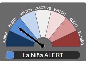
The Bureau of Meteorology says there is a 70 per cent chance of a third La Nina system forming during Spring, which would make just the third time three La Nina systems have formed back-to-back since 1900.
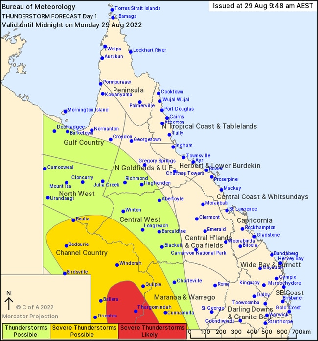
It comes as two consecutive upper level troughs move east from western Queensland, with severe storms and possible flash flooding forecast for the state’s southwest.
While the Bureau has not officially called a La Nina, other experts say a declaration is now a mere formality.
“We’re at the point where regardless of what they call it, we have a La Nina pattern of weather,” Brisbane Weather forecaster, Dave Taylor said.
“History shows that when we have a strong Indian Ocean Dipole and La Nina pattern, we get a stronger and above average wet season.”
Mr Taylor also warned of an early start to the cyclone season.
“I would be very surprised if we didn’t get a Category 4 or above storm crossing the coast somewhere north of Rockhampton,” Mr Taylor said.
“Of course I’m concerned about flooding in the south east but we saw those cyclones come through in similar conditions in 1974 and 2011, so I’m getting nervous for the people in north Queensland as well.”
Mr Taylor said that he thought “Brisbane could see flooding similar to what we had earlier this year but it wouldn’t be on the same scale as what we had in 1974 or 2011”.
The warning comes as the Bureau of Meteorology’s Northern Rainfall Onset Report revealed that “most of Queensland and northeastern Northern Territory have a greater than 75 per cent chance of an early rainfall onset.”
The Northern Rainfall Onset refers to the first accumulation of 50mm of rain after September 1 and is forecast through analysis of different meteorological phenomena including the Indian Ocean Dipole and the El Nino-Southern Oscillation (ENSO).
“A negative phase of Indian Ocean Dipole is currently underway and is forecast to persist into November, (and) although ENSO is currently neutral, there have been signs of recent cooling in the tropical Pacific Ocean along with a 70 per cent chance of a La Niña developing later in 2022,” the report read.
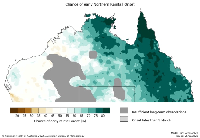
“These forecast conditions, as well as warm ocean temperatures to the north of the continent, are likely contributing to the earlier onset likelihood for much of northeast Australia.”
Wet and wild weather is already moving in across large swathes of Queensland, with systems spanning Brisbane to the far west of the state.
The River City was shrouded in rainclouds on Monday morning, conditions that are expected to continue into Tuesday before returning on Thursday, Friday, and Saturday.
Bureau of Meteorology forecaster Livio Regano said that the rain would start as light drizzle early in the week before intensifying toward the weekend.
“We will probably see around 10-15mm each day from those showers Thursday through to Saturday, and that is significant because our monthly average at this time of year is around 30-40mm,” he said.
“The best days to get outside are going to be Wednesday and Sunday, but it’s going to be a miserable week ahead in Brisbane.”
Mr Regano said the rain was caused by two consecutive upper level troughs moving east from western Queensland where the worst of the weather is expected.
Troughs will dump isolated showers of up to 100mm and severe storms with large hail across parts of the western interior today while the troughs make their way toward the coast.
The Bureau was unable to rule out flash flooding in the region given the ground is “very saturated.”
“We are also watching closely the river levels there to see how they respond to this rainfall because we’ll see another day of isolated totals in excess of 100mm around the Cassowary Coast,” forecaster Peter Classen said on Sunday.

Hail, rain, wind, SNOW: Winter storm on Qld collision course
A rare winter storm threatens to dump 15cm of snow on Queensland's Granite Belt this weekend as forecasters warn of an incoming polar air mass.

‘Can’t be ruled out’: Potential for freak Qld snowfall this week
Queensland could see snow this week with weather models predicting up to 14cm falling on the Granite Belt.