
Brisbane braced for 37C heatwave after severe storms, tornado hammer southern Qld
Brisbane and surrounds are braced for temperatures to climb to as high as 37C following yesterday’s severe storms which battered southern Queensland with hail, heavy rain and a tornado.
QLD weather news
Don't miss out on the headlines from QLD weather news. Followed categories will be added to My News.
Brisbane is set to sweat through an extreme heatwave with maximum temperatures of 37C forecast for the city and surrounds today.
It comes a day after parts of southern Queensland were hit with hail, heavy rain and even a possible tornado after hours of severe weather warnings across parts of the state’s south.
The Bureau of Meteorology has forecast temperatures to skyrocket to 37C in Brisbane, Chermside, Gatton, Ipswich and Oxley, and 36C at the airport, Beaudesert, Logan, Manly, Redcliffe and Mount Gravatt.
It’s likely to trigger serious warnings, particularly for vulnerable residents.
For Brisbane, the bureau has forecast a mostly sunny morning with a 20 per cent change of rain and slight chance of thunderstorms in the afternoon and evening.
As of 6.10am, the mercury had already climbed to 24C (feels like 29C) in the River City.
It comes as forecast models have begun predicting the formation of a Coral Sea tropical low off the coast of Cairns next week.
Gympie and the South Burnett were in the firing line at 7pm, with the Bureau issuing a severe warning for damaging winds, large hail and heavy rainfall.
It said there were severe storms continuing to the east of Proston, tracking towards Gympie.
The Bureau warned that at 6.55pm, a severe thunderstorm likely to produce damaging winds and heavy rainfall that may lead to flash flooding was detected near the area north of Goomeri.
Last night’s storm was moving east and was forecast to affect Kilkivan, the area north of Kilkivan and the area south of Biggenden by 7.25pm, and the area northwest of Gympie, the area north of Gympie and Mt Kanighan by 7.55pm.

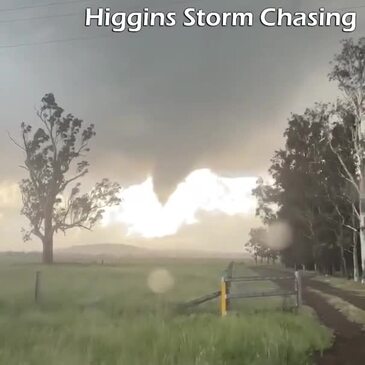
It follows reports of a tornado in a small town in the Western Downs region during a severe storm that lashed the area.
Pictures posted to Higgins Storm Chasing showed a “large tornado” near Kaimkillenbun, located just outside of Dalby, during Thursday afternoons storm.
Ergon Energy recorded 170,000 lightning strikes within 100km of Dalby on Thursday.
“Our crews in some storm-affected areas will have their work cut out for them to get the power back on as wild weather hangs about,” a spokesman said.
“Crews will do a full damage assessment using a helicopter to patrol the lines.
“Until we know the extent of repairs required, we cannot provide accurate restoration timeframes, but some customers will be without power overnight and well into tomorrow.”
It comes after 2500 homes were left without power in the wake of a severe thunderstorm which has battered the Gold Coast on Thursday morning.
Popular amateur forecaster Higgins Storm Chasing described it as a “mini cyclone” and reported wind gusts that had reached 93km/h.
Workers in government-owned buildings were yesterday urged to turn off one computer screen, stop lifts and avoid high-energy tasks such as printing and laminating to reduce pressure on the energy grid as Queensland swelters through a heatwave.
About 2300 customers across the southeast were without power this morning including 800-odd at Tallebudgera, 340 at Russell Island, 300 at Beerburrum, 100 at Enoggera and 90 at Slacks Creek, Energex reported.
Meteorologist Angus Hines said the highest recorded temperature on Wednesday was 46.3 degrees at Birdsville.
“It was 36.4C in Brisbane, 36.7C at the Gold Coast and 35.9C on the Sunshine Coast and around the mid thirties for the coastal locations, it was very sticky and humid,” Mr Hines said.
Mr Hines said much of Queensland would experience similar temperatures on Thursday and Friday.
“Today we won’t see a big shift in conditions, in the central and north the temperatures will be low to mid 40s and from the mid to late 30s for the south east,” Mr Hines said.
“Conditions across the south east could differ as elevated risks of thunderstorms develop.
“The added cloud cover and rainfall that can come in with storms, we actually have some slightly milder temperatures forecast across southeast Queensland today.
“Brisbane will drop from 36C yesterday to about 33C on Thursday, severe weather with heavy rain, damaging wind and large hail are all possible if the storms ramp up today,” he said.
Mr Hines said the south east could expect milder temperatures into the weekend.
“Into Friday evening or early Saturday morning there will be a change in the wind across southern parts of the state, with the cooler southerly flow kick in across the southeastern and then pushing into parts of the central the interior,” Mr Hines said.
“This will result in milder temperatures for the weekend, not a big cool change, but will absolutely shoot temperatures down those mid to upper 30s.
“We’ll return perhaps to what is average for this season,” he said.
In the state’s Far North, forecast models have begun predicting the formation of the season’s first Coral Sea tropical low off the coast of Cairns next week, with a rainfall accumulation expected to exceed 300mm in the next seven days.
While not yet a cause for concern, the ACCESS long-range wind forecast from next Friday is predicting telltale circular wind formations will develop 300km off the coast of Cooktown.
By Saturday, February 1, the system is forecast to move south to be 200km east of Cairns.
Join the conversation
‘Leave now’: Very dangerous flood approaches, as clean-up begins
An emergency alert for a fast-moving flood has been issued, as Far North Queensland residents face more torrential rain in inundated regions, while some struggle to secure supplies and start the clean-up.
Read more
Insurance claims soar as residents return to flood-ravaged homes
Hundreds of homeowners across North Queensland have already filed claims for flood damage, but insurance companies say it’s only the tip of the iceberg with many yet to return home and some not likely to have insurance at all.
Read more