
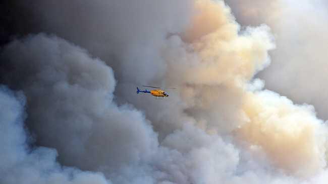
Temperatures, fire danger to soar across southeast Qld
The weather bureau has warned of a severe fire danger, with temperatures are set to soar across southeast Queensland.
QLD weather news
Don't miss out on the headlines from QLD weather news. Followed categories will be added to My News.
TEMPERATURES soaring to the high 30Cs accompanied by hot, dry northwesterly winds are set to push Fire Danger Ratings to "Severe" across Queensland's southeast coast during the next two days.
The Bureau of Meteorology has forecast temperatures along the coast to reach the low to mid 30s, increasing from the mid to high 30s further inland with Gayndah expected to hit 40C tomorrow.
Forecaster Kimba Wong said along the coastal strip afternoon sea breezes would help dampen temperatures compared with further inland, but temperatures would still reach well above the 25C October average.
Ms Wong said the worst fire danger would come tomorrow with the onset of hot, dry, windier conditions.
"There's a chance of storms but with not much or no rainfall," she said.
"They will be more nuisance value with the chance dry lightning may spark fires."
A southerly change into Wednesday would bring with it, cooler conditions closer to the October average.
There's the potential for showers by the end of the week but again any falls would be no more than light.
Gympie was forecast to reach 37C today and tomorrow, Nambour 35C today and 36C Wednesday, Maleny 34C and 35C, Caloundra 33C and then 34C and Noosa and Maroochydore 32C and then 33C.
Hot, sunny conditions would persist throughout today with northwesterly winds at 15-20km/h becoming north, northeasterly at 15-25km/h and then north northwesterly later this evening.
There's a chance of a late thunderstorm today with dry lightning and not much if any rain.
Hot, partly-cloudy conditions tomorrow would see north, northwesterlies from 15-25km/h becoming light through the day.
Temperatures would fall back Wednesday to 25C with partly-cloudy conditions and the slight chance of a thunderstorm. Light winds would become southeasterly to southwesterly at 15-20km/h through the morning and then southeasterly at 15-25km/h.
It should be cooler again Thursday with a 23C maximum predicted for a partly-cloudy day with light winds becoming southeasterly at 15-20km/h before fading.
Expect similar conditions on Friday but with a 50 per cent chance of some rain and the chance of a thunderstorm.
Originally published as Temperatures, fire danger to soar across southeast Qld

PM slams Bruce Hwy, as military might unleashed on flood clean-up
The Prime Minister hasn’t pulled any punches in his assessment of a critical part of the Bruce Highway as he visits flood-ragaved North Queensland, vowing to provide “whatever support is necessary”.
‘Big impacts’: New 300mm rain bomb, cyclone threat for NQ
Flood-soaked NQ communities have been warned of more heavy rain that could lead to life-threatening flash flooding in coming days – and even the slight chance of a tropical cyclone developing off the coast.