
Southeast Queensland on high alert for renewed threat of severe storms
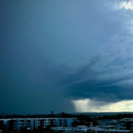
Wild weather has battered South East Queensland for a second night in a row, with multiple supercell storms bringing down trees, halting trains and flooding streets. And there’s more to come on Friday.
QLD weather news
Don't miss out on the headlines from QLD weather news. Followed categories will be added to My News.
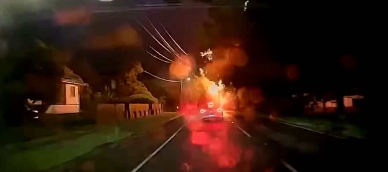
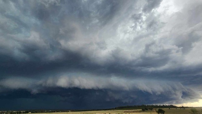
Severe storms bringing down trees, halting trains, closing roads and flooding streets have smashed the state from the Gold Coast to Emerald, with more wild weather forecast for Friday.
Large thunderstorms began impacting southeast Queensland from about 3pm on Thursday with warnings going on into the night.
Severe storms wreaked havoc on the Sunshine Coast throughout the afternoon with a train line cut and trees down.
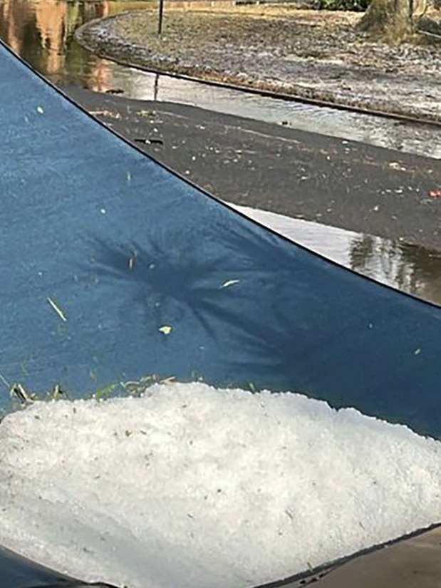
Hail smashed areas west of Brisbane with 4cm hailstones recorded at Greenbank and Wyaralong and 3cm hail at Haigslea, near Ipswich.

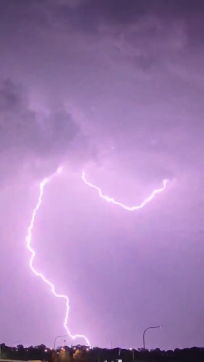
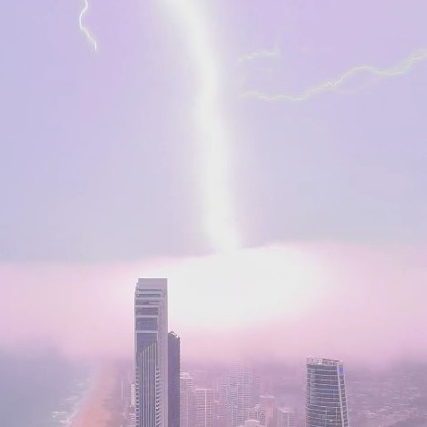
According to Energex, this afternoon and this evening the south east recorded more than 163,300 lightning strikes, bringing the 24 hour total up to 292,500 strikes.
While a whopping 58mm of rain fell in just 30 minutes at Spring Mountain near Redbank about 5.30pm, while wind gusts of up to 113km/h were recorded at Blackwater Airport at 5.20pm.
At 7.58pm the Bureau of Meteorology warned of severe thunderstorms likely to produce damaging winds, large hailstones and heavy rainfall that may lead to flash flooding for people in parts of the Gympie council area.
The alert warned that, at 7:50pm, a severe thunderstorm likely to produce damaging winds, large hailstones and heavy rainfall that may lead to flash flooding was detected near Kilkivan and the area north of Goomeri.
“This thunderstorm is moving towards the east,” the warning said.
“It is forecast to affect the area northwest of Gympie by 8:20pm and Gympie, the area east of Gympie and the area northeast of Gympie by 8:50pm.”
Lightning in Brisbane delayed the start of cricket at the Gabba with the toss for Australia verse Pakistan not scheduled to happen until the severe weather passed.
The toss has been delayed due to some lightning around the Gabba #AUSvPAK pic.twitter.com/7x2LSpJ7Lm
— cricket.com.au (@cricketcomau) November 14, 2024
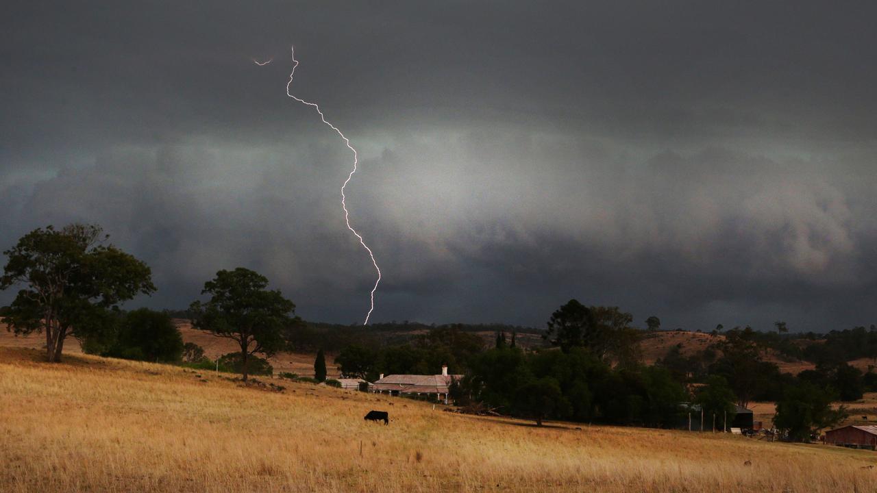
As severe storm cells threatened parts of the south east, central Queensland were feeling the effects of storms that rolled through on Thursday afternoon with more than 11,000 residents without power.
Ergon Energy took to Facebook and said a severe lightning storm hit a major high-voltage line that supplies “a large chunk” of the Central West, knocking out power for 11,000 people from Emerald and Clermont, west to Longreach and down to Blackall and Tambo.
“Crews are patrolling the suspected damage area and we’re looking at all options to get the lights on ASAP; however we won’t be able to estimate restoration times until we’ve pinpointed the problem,” the post read.
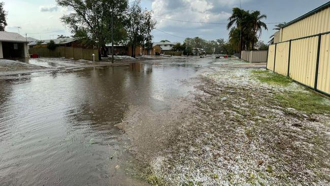
Videos and pictures from Emerald show the aftermath of the severe storm, with hail coating the ground like snow and streets flooded.
It comes after the Sunshine Coast was smashed with commuters left stranded with severe thunderstorms halting a line of the Southeast Queensland train network.
Sunshine Coast line trains were suspended just before 4pm between Caboolture and Nambour stations due to an overhead power line issue as a result of a severe storm.
Services were not restored until about 10.30pm.

Residents in areas hit hard with the severe weather described the wall of storms on the radar as a “wall of death”, with many posting to storm chaser Facebook pages that they would like a reprieve from the early season storms.
Both trains along the Sunshine Coast rail line that were stalled were evacuated with all passengers taken by bus to their destinations.
Queensland Rail continued to work on the overhead power lines into the night, with delays for commuters set to continue.
Two train lines carrying passengers have been stalled along the tracks as a result of the suspension, including the 121 Gympie North train which is stalled between Palmwoods and Eudlo stations, as well as the 107 to Nambour which is near the Eudlo platform.
Queensland Rail said there were crews on scene now attempting to fix the issue in order for trains to safely get back up and running.
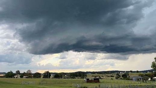
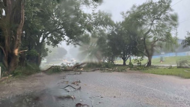
The severe thunderstorm has smashed the Sunshine Coast region, with trees down across roads and hail smashing down on properties.
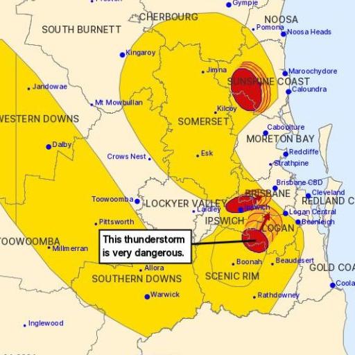
Earlier the Bureau of Meteorology issued a severe thunderstorm warning at 4.35pm for residents in areas of Ipswich, Logan, Somerset, Scenic Rim, Sunshine Coast, Brisbane City and Moreton Bay.
It advised severe thunderstorms, likely to produce damaging winds, large hailstones and heavy rainfall that may lead to flash flooding, were detected near Boonah, Kilcoy, Lowood and Kooralbyn.
These thunderstorms are moving towards the east to northeast. They are forecast to affect Beaudesert, Peachester and Crohamhurst by 4:55pm and the area west of Kilcoy, Mount Beerwah and Landsborough by 5:25pm.

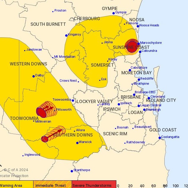
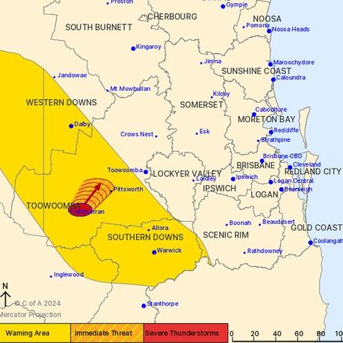
A more general severe thunderstorm warning was current at 4.30pm for parts of the Central Highlands and Coalfields, Capricornia, Wide Bay and Burnett, Darling Downs and Granite Belt and Southeast Coast districts.
It advised thunderstorms are likely to impact Warwick, Dalby, Emerald, Jimboomba, Nambour and Nanango.
The alerts were just two of several which had been issued throughout Thursday afternoon and expected to continue into the evening.
Small hail was recorded in areas west of the Sunshine Coast.
The BOM weather alerts stated that a trough was extending over the southeast inland of Queensland with a warm, humid and very unstable air mass on its eastern side.
Scattered thunderstorms are expected to develop east of this trough during the afternoon and evening.
Moderately strong winds in the upper atmosphere will promote some organised severe thunderstorms over southeast of Queensland, the warnings read.

While temperatures will begin to slightly drop on Friday, humidity will likely stick around with much of Southeast Queensland set to be hit by more severe thunderstorms right to the end the week.
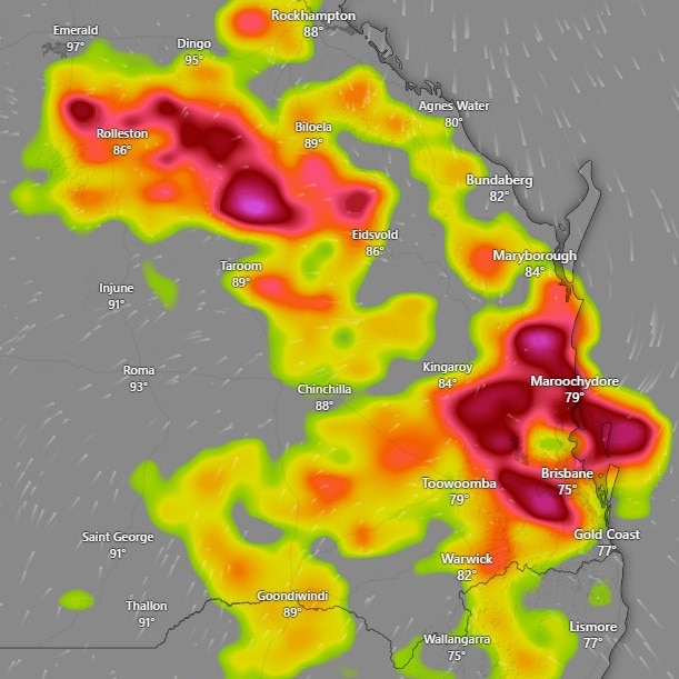
The Bureau of Meteorology’s Angus Hines said there would be widespread storms from the Capricornia Coast down to the south coast, including the Wide Bay and pushing inland into the Scenic Rim and Eastern Downs.
“The possibility of severe storms exists through this region during the afternoon and evening hours as well, where we could see some heavy rain, large hail or damaging wind gusts,” Mr Hines said.
The afternoon storm warnings and forecast for Friday come after a volatile storm system hammered South East Queensland yesterday.
Wednesday night’s “ferocious” green monster sent down more than 215,000 lightning strikes and left 14,000-plus homes and businesses without power during the night.
The supercell smashed Brisbane and the southeast, lashing the regions with golf ball-sized hail, damaging winds and torrential rain.
The Bureau of Meteorology has forecast another threat of severe thunderstorms that are likely to impact SEQ, particularly the Sunshine Coast, Lockyer Valley, the Gold Coast hinterland and potentially Brisbane.
“Some storms may become severe,” BOM forecaster Angus Hines said.”
ðŸŒ©ï¸ Today's thunderstorm FORECAST (14/11): Severe storms LIKELY over #SEQld including #SunshineCoast, #LockyerValley, #GoldCoast hinterland & border ranges, POSSIBLE elsewhere in the south-east.
— Bureau of Meteorology, Queensland (@BOM_Qld) November 14, 2024
Risk of heavy rain, large hail & damaging winds.
Warnings: https://t.co/FBmpsInT9opic.twitter.com/2Mqnw5KL93
The storms carry the threat of heavy rain, large hail and damaging winds.
Higgins Storm Chasing, which correctly predicted Wednesday’s carnage, again issued a warning for residents to be prepared.
“A volatile weather pattern remains in place but slightly further east and north than yesterday with extremely high instability and moisture levels,” Higgins posted to social media.
“Severe cells are likely and a few supercells are possible starting inland then reaching the coast.
“The strongest storms could contain tennis ball-sized hail and destructive winds that may cause damage to homes, property and infrastructure plus microbursts with extremely heavy rain leading to rapid flash flooding.
“This isn’t some hyped up, made up bulls*** to cause fear, it is a genuine forecast using multi model forecast data, our skill and experience posted for people to be forewarned and prepared.”
Energex spokesman Danny Donald said at 10am on Thursday Energex had worked to restore power to 1350 homes.
“There are currently 347 homes without power,” Mr Donald said.
83mm in 60 mins: Morning storms after inland Qld hammered
Severe thunderstorms have hit parts of inland Queensland overnight, with one area recording more than 80mm in an hour, as more flared up this morning.

Former MP withdraws senate ticket to focus on new role
A former Newman government minister has has stepped away from his senator ambitions to instead focus on helping flood-wrecked North Queensland rebuild.