
Queensland weather: Potential for 150mm falls over four days
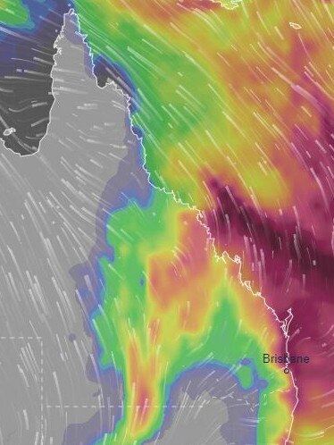
Forecasters are monitoring a massive weather system off the Queensland coast that could dump 150mm of rain on parts of the state’s southeast over four days.
QLD weather news
Don't miss out on the headlines from QLD weather news. Followed categories will be added to My News.
South East Queensland could face days of drenching rain with amateur weather forecasters predicting falls up to 150mm depending on where and when a low forms.
A low pressure system is expected to form off Hervey Bay from Thursday, potentially triggering four days of rainfall from Bundaberg south to Brisbane and the Gold Coast.
The heaviest falls are expected north of the Sunshine Coast, but Brisbane Weather’s David Taylor would not rule out significant totals for South East Queensland.
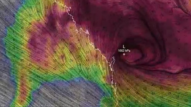
“If the system develops further inland – further to the south – this heavier rain will increase and move south,” he said.
The Bureau of Meteorology’s Felim Hanniffy said conditions would start to deteriorate late Wednesday.
“The main action will be after Wednesday. Thursday and Friday will bring a lot more cloud and the potential for increasing showers,” he said.
“After a beautiful start to the week, it’ll end with some wet weather.
“But it does push off the coast again on the weekend so we’ll start to see the wettest conditions moving away over the weekend, but still the potential for showers,” Mr Hanniffy said.
With the cloudiest conditions expected on Friday, the weather is set to improve slightly on Saturday with some lingering showers sticking around, before clearing up even more on Sunday.
Meanwhile, the cloud cover could also bring chillier conditions with Mr Hanniffy saying daytime temperatures on Thursday and Friday could be around 2C to 4C below average.

Ice ice baby: Spectacular images of unseasonal frost as Qld freezes
Queensland’s overnight temperatures will increase to double digits in the coming days, following the coldest start to winter in 16 years, bringing frost and ice to many regions. SEE THE PHOTOS

City’s coldest June start in 16 years, feels like MINUS 9.8C out west
Southeast Queensland is shivering through its coldest morning in more than 15 years but feels-like temperatures have dropped to insane levels in the southern inland.