
Saturated parts of Queensland warned to brace for more rain
Parts of Queensland still saturated from last week’s significant rainfall event are bracing for another drenching, with up to 70mm expected over three days.

QLD weather news
Don't miss out on the headlines from QLD weather news. Followed categories will be added to My News.
Saturated parts of Queensland’s coastline are bracing for more rain later this week, as towns continue the mammoth clean up after last week’s deluge.
The Bureau of Meteorology has earmarked Friday and Saturday as the days which the most rainfall activity will occur in the state, due to a trough forming off the coast.
BOM meteorologist Helen Kirkup said Friday’s rainfall was most likely to affect the Capricornia coast, down to Wide Bay and up to the Mackay coast.
“Then Saturday the rain will impact more of the Wide Bay, Sunshine Coast, Brisbane and Gold Coast area,” Ms Kirkup said.
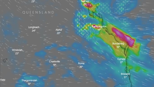
Parts of the Wide Bay region, including Bundaberg, are set to cop up to 70mm of rain over 72 hours.
Gympie could receive 40mm while Rockhampton is in line for 45mm.
Ms Kirkup said moisture from the Coral Sea courtesy of La Nina was to blame for the persistent rainfall.
A few showers over coastal #QLD today but not expecting too much out of them. Friday will be the next day for rain in the east so check the forecasts, warnings and radars at https://t.co/uFerbbeIoQ and remember "if it's flooded forget it" pic.twitter.com/LNThE57xAl
— Bureau of Meteorology, Queensland (@BOM_Qld) May 17, 2022
“The rainfall figures will be forecast and reforecast between now and the weekend,” she said.
“We will have to wait and see in terms of flash flooding in localities across southeast Queensland,” she said.
A leading meteorologist has warned Queenslanders heading out to cast their votes in this weekend’s Federal election to pack an umbrella.
Sky News Chief Meteorologist Rob Sharpe said Queenslanders should definitly bring their brolly when they head out to vote on Saturday.
“There is still some risk with this because we are still seeing significant rainfall over already wet catchments,” Mr Sharpe said.
“We could see either flash flooding or riverine flooding from this event and the bulk of the rain is going to be from the central coast down into parts of South East Queensland.”
Mr Sharpe said the heaviest of the rainfall could be situated between the two aforementioned areas, with rain over inland areas too including the Central Highlands.
“You’d have to say that Queensland’s weather is under the influence of the prevailing La Nina event at the moment,” he said.
“That is helping to contribute to the significant rain, by the end of May it is going to be one of the top three wettest Mays on record.”
There was some impressive rainfall totals yesterday, with Maleny copping 52mm in just half an hour and other Sunshine Coast localities getting over 100mm.

Ice ice baby: Spectacular images of unseasonal frost as Qld freezes
Queensland’s overnight temperatures will increase to double digits in the coming days, following the coldest start to winter in 16 years, bringing frost and ice to many regions. SEE THE PHOTOS

City’s coldest June start in 16 years, feels like MINUS 9.8C out west
Southeast Queensland is shivering through its coldest morning in more than 15 years but feels-like temperatures have dropped to insane levels in the southern inland.