
Queensland weather: Rainfall totals in excess of 100mm in northwest Outback centres
Weather records have fallen in Queensland’s Outback, where some areas have copped more than 100mm of rain in less than 24 hours. It comes as wet weather moves toward the southeast.
QLD weather news
Don't miss out on the headlines from QLD weather news. Followed categories will be added to My News.
Queensland’s southern corner has been warned of a “rain sandwich” as a weather system moves across the state after delivering huge rainfall totals and freezing temperatures in parts of the Outback.
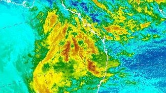
Rainfall figures from the Bureau of Meteorology show 101.2mm has fallen at May Downs, near Mount Isa, in the past 24 hours.
Mount Isa itself copped close to 80mm, which is ten times the July average.
More than 81mm fell at The Monument, 77.6 at Julia Creek and 64.4mm at Cloncurry.
Maximum temperatures climbed no higher than 12.3 in the same northwest area.
Bureau of Meteorology Jackson Browne said there had been quite a bit of unseasonable rainfall in association with the northwest cloud band trundling across the state.
Mr Browne said there would be a “noticeable pick up in showers” as the rain moves southeast.
“We’re expecting that northwest cloud band and to bring moisture southeast towards Queensland this week,” Bureau of Meteorology senior meteorologist Jackson Browne said.
“Areas like Brisbane, Gold Coast and Sunshine Coast can expect to see around that 10-15mm mark.
“There’ll be a pick up in rainfall through those parts today as well as some of the areas north of Townsville over the Lower Burdekin and up to around Cardwell.
“By the time we get up into northern NSW, areas like Ballina and Grafton, the rain is forecast between 20-40mm – and only about half that by the time we get to Sydney.”
“It is going to be a pretty wet one across Queensland really,” he said.
Mr Browne said we will see “a rain sandwich” as areas like Miles, Dalby and Roma will also experience showers today.
“Warnings for sheep graziers have been issued just because of a combination of cold, rainy and windy conditions in the central west,” he said.
Emergency Services Minister Mark Ryan was briefed on the unfolding weather situation at the weekend.
“This … will move across most of the state in the next couple of days and in some areas they might experience minor flood levels, particularly in the west of the state,” he said.
“(We’re) just encouraging everyone to be aware of the weather bureau briefings, as well as also taking the necessary precautions in respect to severe weather warnings.”
Showers are expected to persist in the east and southeast of the state through Wednesday and Thursday.
The weather system could see some areas receive their monthly average rainfall – or more – in a day.

Feels like -5.3C: Icy blast sends temps plummeting again
South East Queensland has again shivered through a freezing start to the day, as a brutal cold front continues to blast the region with subzero temperatures, made worse by chilling winds.

Feels like MINUS 7.1C: Brutal cold front blasts southern Qld
A brutal cold front is blasting across southern Queensland with subzero temperatures and widespread frost.