
Queensland weather: Major flood warning for Upper Brisbane River
A number of people have been rescued from vehicles swept away in flood waters and a major flood warning has been issued for the Upper Brisbane River as fierce storms bring in torrential rain across the southeast. It comes as a cyclone edges closer to the Australian coast.
QLD weather news
Don't miss out on the headlines from QLD weather news. Followed categories will be added to My News.
AFTER severe storms delivered more than 125mm in a matter of hours, the Brisbane River at Gregors Creek, west of Kilcoy, exceeded its minor flood level of 4m on Monday night.
The Bureau of Meteorology has issued a major flood warning for the Upper Brisbane River, predicting it would reach major flood levels of 7.5m by Tuesday morning.
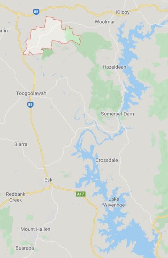
Forecaster Matt Bass said areas of the Upper Brisbane River between Gregors Creek and Lake Wivenhoe would experience moderate to major flooding overnight.
“Gregors Creek is a creek that flows into the Brisbane River and it’s likely that we are seeing significant flash-flooding along that creek at the moment,” he said late on Monday.
“From where that flooding is happening, that water will flow down the Brisbane River for about 15km and it’ll reach the top end of Lake Wivenhoe into the dam and it’ll just contribute into the dam and there won’t be any further flows downstream.
“If you’re along that Gregors creek area or the surrounds between Toogoolawah and Kilcoy there is going to be some pretty significant flooding,” he said.
“Those floods will probably peak early tomorrow morning and then move into Wivenhoe, it won’t be particularly long lasting but if you’re there now it could be pretty significant.”
The flooding comes as a severe storm warning was cancelled for southeast Queensland about 10.30pm.
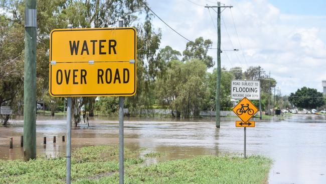
Flash flooding was reported across the region, including on the Bruce Highway at Marlborough, the New England Highway at Glenaven and Brisbane Valley Highway at Toogoolawah.
Emergency services rescued multiple people who were in cars when they were swept away near Toowoomba.
Swift water rescue were called after two vehicles had been swept off Kingsthorpe Rd in Yalangur about 7.20pm.
At the same time, about 20km away, one person was swept off the road by floodwaters in Meringandan.
Earlier, an elderly man was rescued from his vehicle trapped in floodwaters on Bowhill Rd in Willawong in outer Brisbane.
All occupants were assessed by paramedics and did not require transport to hospital.
The bureau earlier warned that thunderstorms were likely to cause “life threatening” and very dangerous flash flooding in affected areas.
More than 100mm of rain was recorded in just one hour at Gregors Creek, while the Dalgangal Rd Alert, south-west of Bundaberg, received 93mm and Greenbank recorded 62mm. 85mm was also recorded in an hour at Greys Plains Road Alert, south of Laidley, while Toowoomba received 69mm, Oakey 50mm and Roma 28mm.
Residents on the western Darling Downs were on Monday evening told to prepare to move to higher ground and secure their belongings as severe thunderstorms bring flash flooding.
An emergency alert flood message was issued for Jandowae residents from the Western Downs Regional Council.
The storms also left more than 2270 homes in Brisbane and the Sunshine Coast without power at one stage on Monday night.
LOW EDGES CLOSER TO AUSTRALIAN COAST
Meanwhile, a tropical cyclone detected in The Coral Sea could move towards the southeast coast later in the week, the latest in suite of chaotic wet weather to hit the east coast.
Bureau of meteorology forecaster Shane Kennedy said Cyclone Uesi, currently a category 2 system, is sitting off the coast of New Caledonia and is likely to intensify over the next couple of days.
“It’s having major impacts in New Caledonia and is likely to intensify,” he said.
“Later in the week, potentially, it may start to track towards the south-west and may start moving into our area on Thursday.
“At this stage there is a slight risk of it posing a threat to Lord Howe Island.”
Mr Kennedy said the tropical cyclone is having “no direct impact” on Queensland at present, but the bureau will be monitoring the situation very closely and should have a clearer idea about how much the cyclone with impact the southeast by Wednesday.
“It’s certainly a long way out at this stage, it’s not expected to have any direct impact on the Queensland coast later in the week, though it may potentially bring some increased season swell,” he said.
“At this stage it’s looking to be between 2-3m on Thursday and Friday, so once the swell starts to get up to the 2-3m range that’s when it can start to pose a danger.”
TOWN GETS TWO YEARS’ WORTH OF WATER IN 48 HOURS
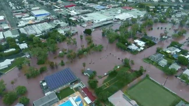
EARLIER: A southern Queensland town has had two years’ worth of drinking water flow into its dam after downpours across the state as a severe thunderstorm warning is issued for a large portion of the state.
The Gold and Sunshine coasts were among the hardest-hit regions over the past three days, with some drenched by more than 200mm of rain in just 24 hours.
Coolangatta yesterday received the highest daily rainfall in the state at 200.6mm, followed by Elbow Valley near Warwick at 121mm.
Residents of Warwick, southwest of Brisbane, now have some respite from the crippling drought in the region after dam levels nearly doubled overnight in Leslie Dam, which supplies water to the town and surrounding communities, rising from 7.66 per cent to 12.64 per cent between Saturday afternoon and Sunday morning, according to SunWater.
Southern Downs Mayor Tracy Dobie said as much as two years worth of drinking water had flowed into Leslie Dam.
“We have had almost as much rain in January and February as we had in all of 2019,” she said.
The community of Stanthorpe near the NSW border also received much-needed rain. The community officially ran out of drinking water in January, needing to truck water from Connolly Dam 60km to the town’s north.
Ms Dobie said Connolly Dam received good rain but the town’s main supply, Storm King Dam, did not receive enough to halt water trucking.
“We got one month of water into Storm King Dam, but we are looking at needing six months worth of rain to stop the trucking,” she said.
Elsewhere, Saturday saw Rolleston Airport hit with 149.6mm while Eumundi on Friday was pelted with more than 130mm of rain, followed by Clontarf with 117mm.
Heavy rainfall smashes Queensland but brings relief to drought-hit regions
NSW flood chaos: Evacuations, landslides
It comes as more than 900 calls were made to the State Emergency Service across the state for roof damage and water inundation as the Bureau of Meteorology put several flood watches in place.
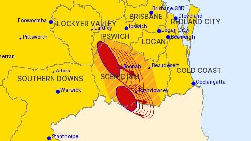
The Bureau of Meteorology is forecasting more storms across the southeast today and at 11.57am issued a severe thunderstorm warning for people in Darling Downs and Granite Belt and parts of Central Highlands and Coalfields, Capricornia and Maranoa and Warrego forecast districts.
The storms are likely to produce heavy rainfall that may lead to flash flooding, large hailstones and damaging winds in the warning area over the next several hours.
Locations that may be affected include Warwick, Toowoomba, Dalby, Roma, Emerald, St George, Blackwater, Stanthorpe, Goondiwindi, Carnarvon National Park, Mungindi and Tara.
“There’s a continuation of showers and thunderstorms tending to be a little more isolated as we head further into the week – there is a potential for severe thunderstorms and with that heavy falls,” BOM forecaster Peter Markworth said earlier.
“With the saturated soil, particularly in the southeast, makes it even more susceptible to flash flooding than other parts of the year.”
HIGHEST DAILY RAINFALL FOR QUEENSLAND FEBRUARY 8 SATURDAY
149.6 Rolleston Airport
86.0 Namarah
78.0 Southwood
69.2 Scherger RAAF
68.4 Wyaga TM
60.0 Bramwell
56.6 Langley TM
56.0 Fenton TM
55.0 Cape Moreton Lighthouse
053.2 Lady Elliot Island
HIGHEST DAILY RAINFALL FOR QUEENSLAND FEBRUARY 9 SUNDAY
200.6 Coolangatta
121.0 Elbow Valley Alert
115.2 Oakey Aero
113.6 Langley TM
111.0 Pratten Condamine River
110.0 Warwick (Scots College) TM
106.0 Yangan Alert
104.8 Warwick
103.6 Gold Coast Seaway
103.0 Burleigh Waters Alert

Monster weather system brings storm, heavy rain to Qld
Brisbane and surrounding parts of the southeast have been hit by storms and heavy rainfall this afternoon as a 3000km-long monster low moves across the state.

Wild storms, polar blast as 3000km monster low barrels towards Qld
The system, which stretches 3000km from north to south and encompasses 30 per cent of Australia, is forecast to pack a punch when it hits Queensland.