
Queensland weather: Latest Bureau of Meteorology models show likely La Nina return
El Nino-more? The latest climate modelling from the weather bureau has revealed La Nina could return this winter bringing months of above average rainfall.
QLD weather news
Don't miss out on the headlines from QLD weather news. Followed categories will be added to My News.
Queensland is braced for yet another round of weather whiplash with La Nina forecast to return for a fourth time since 2020, likely bringing above average rainfall for the remainder of the year.
It comes after the state was battered by a wild summer storm season plagued with floods and cyclones and February rainfall totals that broke decade-long records.
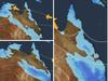
Latest climate modelling by the Bureau of Meteorology shows El Nino has decayed significantly, but reprieve will be brief with Sky News Meteorologist Rob Sharpe predicting La Nina expected to appear in a matter of weeks.
Bureau forecasting shows a potential La Nina arrival in June and while associated rainfall intensity remains uncertain, long range forecasting shows a 75 per cent chance of the South East receiving between 100-200mm of rainfall and a 25 per cent chance of it receiving 300-400mm between May and July.
Mr Sharpe two weeks ago declared there was an 85 per cent chance of a return of La Nina, stating El Nino had peaked in December and was already over.

A bureau spokeswoman said El Nino event was not yet over due to persistent sea surface temperatures, but there was a 40 per cent chance a La Nina would follow.
“In the bureau’s history of ENSO events, a La Nina has followed El Nino in around 40 per cent of events since 1900,” she said.
“Around 50 per cent of years following an El Nino have been ENSO-neutral, while in around 10 per cent of years El Nino has redeveloped.”
International climate models suggest the central tropical Pacific Ocean will continue to cool in the coming months, with four out of seven climate models indicating the central Pacific is likely to return to ENSO-neutral by the end of April.
While four out of seven international models are predicting a La Nina by late winter, the bureau warns El Nino and La Nina predictions made in early autumn tend to have lower accuracy than predictions made at other times of the year and current forecasts of the ENSO state beyond May should be treated with caution.

Global sea surface temperatures (SSTs) have also remained the highest on record for all respective months between April 2023 and February 2024 with March tracking to be the warmest ever recorded.
Maximum temperatures are 60-80 per cent more likely to be above normal across eastern Queensland this month, while western areas are forecast to be slightly cooler than usual.


‘Can’t be ruled out’: Potential for freak Qld snowfall this week
Queensland could see snow this week with weather models predicting up to 14cm falling on the Granite Belt.

Monster weather system brings storm, heavy rain to Qld
Brisbane and surrounding parts of the southeast have been hit by storms and heavy rainfall this afternoon as a 3000km-long monster low moves across the state.