
Qld weather: Tropical cyclone activity to ‘rapidly’ increase in SEQ
A new report has found South East Queensland is more at risk of tropical cyclones than ever before, as Lord Mayor Adrian Schrinner takes aim at the state government for not doing enough to prepare residents.
QLD weather news
Don't miss out on the headlines from QLD weather news. Followed categories will be added to My News.
Tropical cyclones will wreak havoc on Queensland this storm season, according to top scientists.
At least four cyclones are expected to threaten the Sunshine State between now and next April, with scientists warning they will bring stronger winds and intensified rainfall compared with previous years, due to climate change.
The Bureau of Meteorology has released its tropical cyclone outlook, saying Queensland has a 74 per cent chance of seeing more than four cyclones this season, with at least one or two expected to make landfall.
It prompted Brisbane Lord Mayor Adrian Schrinner to voice his concerns over the state’s ability to prepare residents, as he accused the state government of doing nothing to improve its severe weather alert system which he said “epically failed” Queenslanders during the February flood disaster.
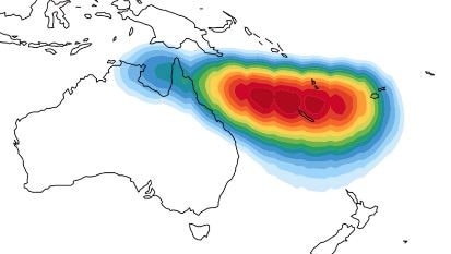
Cyclones could impact the state within weeks and are expected to fall anywhere along the east, including southern parts of the state which are becoming less immune to cyclone activity, according to a new report by Australia’s top atmospheric and environmental scientists.
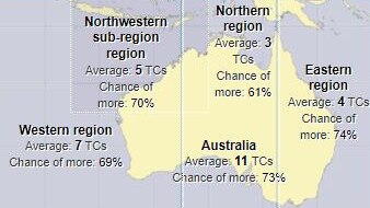
The Tropical Cyclone Impact Report released in September studied historical cyclone patterns and current climate modelling to predict what future impacts cyclones would likely have on Australia.
It found while cyclones had become less frequent, future cyclones would become more intense, bringing stronger damaging winds, increased rainfall and severe flood risk due to warming ocean temperatures.
The report also found a trend of increasing landfall frequency of Category 4 and 5 cyclones since 2011, with the proportion of CAT 5 cyclones predicted to increase by 50 per cent in Australia by the 2030s and 150 per cent by the 2070s.
“Over the last two decades, the number of intense cyclones making landfall on the Queensland east coast has increased substantially,” the report said.
“Warming oceans off South East Queensland and New South Wales will enable these cyclones to retain higher intensities further south and to penetrate further inland.
“TC risk is therefore predicted to increase most rapidly in the South East Queensland (and) northeast New South Wales regions.”
Laura Bokel from the Bureau of Meteorology said it was impossible to predict exactly where TCs would occur in Queensland, how many would occur or what category strength they could develop into until a tropical low formed, which usually happens when ocean temperatures warm to the “magic” 26.5C.
Ms Bokel agreed there had been a downward trend of cyclones in Australia since 1988, but those that did arrive were of “greater intensity.”
“To get a tropical cyclone, you need tropical waters, the magic number is 26.5 degrees,” Ms Bokel said.
“Exactly where, and the specifics are tricky are more part of a seven-day outlook when the low forms, allowing us to track its activity.
“So if you see trends of waters warming further south, then you see the tropical cyclones also forming further south.”
The report said cyclone peak wind speeds and rainfall rates were also increasing and Queensland buildings would need to be fortified as soon as possible as they are currently only built to withstand CAT 1 and 2 cyclones.
“Cities along the subtropical eastern Australian coast – especially those in the subregion of Queensland-NSW … are particularly vulnerable to even moderate TCs given lower building code wind load standards in relation to the northern parts of Australia,” the report states.
“Should these wind and rainfall trends continue, this raises the prospect that current wind loading codes and flood planning zones may not protect people and property as well as they have in the past and may severely underperform in the future.
“Given that this area (South East Queensland) currently has lower wind loading standards than coastal areas to the north, it is critical that the building regulatory authority considers this rapidly changing risk for homes and structures being designed and constructed now.”
Ms Bokel said Queenslanders must start preparing for TC season now, and the wild weather systems that usually accompany any TC activity.
“Remember you can get the storm surge as well from cyclones.. even if they're not maintaining cyclone strength, the impacts are still dangerous and we want people to be prepared for that,” she said.
“It doesn’t have to be that wind, you look at the track of Debbie, it went inland and kept tracking south and hit the coast, causing so much damage in terms of rainfall.
“On the Sunshine Coast, Brisbane, we had gusts up to 131km/ph it was typical low, which had actually intensified a that point and was still bringing those winds guist and 200mm of rainfall in the Gold Coast.”

Meanwhile, Cr Schrinner said the Bureau’s latest cyclone warning shows Queenslanders have just weeks to prepare for another severe La Niña season.
“I am really concerned that little has been done to improve the National Emergency Alert system operated by state governments,” he said.
“The system took up to 14 hours to distribute messages to residents, which is grossly inadequate.
“I am deeply troubled to learn state authorities are only now getting around to reviewing the system. We don’t need another review. We need urgent action.
“The National Emergency Alert system can’t save lives if it’s incapable of distributing messages before disasters happen.”
Emergency Services Minister Mark Ryan disputed the comments, saying the government was already undertaking “considerable further work” to strengthen its disaster management system.
“As the Lord Mayor well knows, the Emergency Alert system is a national system,” Mr Ryan said.
“The IGEM Review report specifically includes a review of the use of the National Emergency Alert system during the Southeast Queensland flood event.”
The Bureau of Meteorology has recently updated its weather App to include location-specified weather notifications.
App users can list their preferred locations under “favourite” locations and received alerts about extreme weather events happening in that area.
For more information on the app or to download it onto mobile phones or tablets, click here.

Feels like MINUS 7.1C: Brutal cold front blasts southern Qld
A brutal cold front is blasting across southern Queensland with subzero temperatures and widespread frost.

‘Gets pretty wild’: Qld weather buff on the spot for epic US storms
A Queensland weather forecaster shares unbelievable images after he spent almost three months chasing tornadoes in the US this year.