
Storms, power outages follow brutal heat, humidity
More than 25,000 properties were without power Monday night as storms hit the southeast after a scorching day. A severe thunderstorm warning has been issued for damaging winds, heavy rainfall and large hailstones.
QLD weather news
Don't miss out on the headlines from QLD weather news. Followed categories will be added to My News.
More than 25,000 properties were without power Monday night as storms lashed the southeast.
It comes after a scorching day which saw Brisbane’s “feels like” temperature hit 41C and inland areas reach 45C.
At 6.15pm there were 41,230 properties without power. Of those 16,798 were in the Moreton Bay Regional Council area and 12,129 in Brisbane. The figure had dipped to 26,804 properties by 7.30pm.

Energex spokesman Justin Coomber confirmed the outages were due to a “mixed bag of severe weather” including the ongoing heatwave and a burst of storm activity.
“Outages are localised, we’ve had trees fall down and one transformer taking a direct lightning hit,” he said.
“The supply is there, it’s not a supply issue but localised heat issues are affecting outages, things like fuse blows.”
Mr Coomber confirmed crews were on the ground working to restore the tens of thousands of affected customers, with power likely to be restored within hours.

The Bureau of Meteorology updated a storm warning for damaging winds, large hailstones and heavy rain, issuing the update at 7.33pm for people in parts of Gympie, Somerset and South Burnett council areas. Before the update, an earlier warning had also included Sunshine Coast and Moreton Bay.
“At 7.25pm, a severe thunderstorm likely to produce damaging winds, large hailstones and heavy rainfall that may lead to flash flooding was detected near the ranges south of Jimna and the area east of Nanango,” the latest warning said.
“This thunderstorm is moving towards the north. It is forecast to affect the area northwest of Jimna by 7.55pm and Elgin Vale, the area between Nanango and Goomeri and the area east of Murgon by 8.25pm.”

A separate severe thunderstorm warning for heavy rainfall, damaging winds and large hailstones has been updated and was at 7.31pm issued for people in parts of Wide Bay and Burnett and Southeast Coast forecast districts.
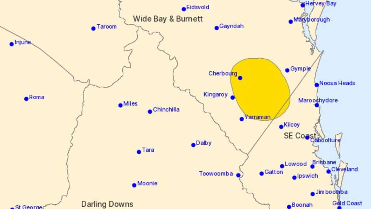
“A trough combined with a moist and unstable atmosphere triggered thunderstorms in the State’s southeast this evening,” the warning said.
“Severe thunderstorms are likely to produce heavy rainfall that may lead to flash flooding, damaging winds and large hailstones in the warning area over the next several hours. Locations which may be affected include Cherbourg, Wondai, Murgon, Imbil and Nanango.”
Energy Minister Mick de Brenni had earlier assured Queenslanders Monday night that the energy grid was “holding up well.”
“Queensland’s energy system is holding up well,” he said.
“The Australian Energy Market Operator is monitoring conditions and we expect to maintain adequate supply to meet demand.”
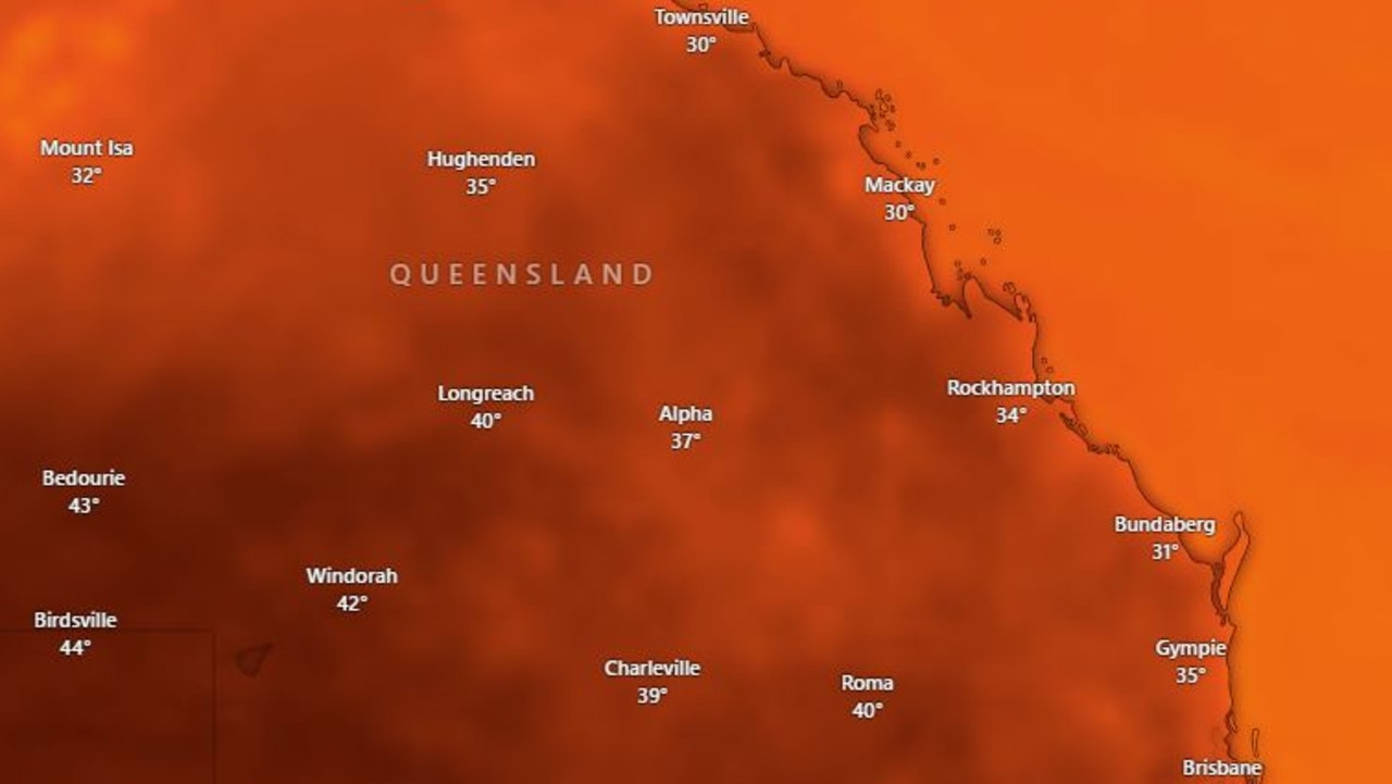
Monday was a sweltering day for the state, with Brisbane recording an apparent temperature of above 41C at midday, as Outback centres had actual maximums in the mid-40s.
Birdsville and Ballera in the Channel Country recorded the state’s highest temperature of 44.5C, but the apparent temperature in Birdsville was even higher with 45.2C the “feels like” temperature at 3pm. Meanwhile St George hit 44C.
Residents in Brisbane were sweltering through what felt like a temperature of 41.1C by 11.30am - six degrees hotter than the actual temperature of 35.4C. These were the hottest temperatures for the capital on Monday, with the mercury dipping to 33.3C by 4.10pm.
Humidity levels weren’t helping, with all south east areas measuring above 60 per cent humidity, and some hitting over 80 per cent humidity by midday.
Coolangatta reached 77 per cent humidity and 30C before 10am, while Cape Moreton hit 81 per cent humidity and Logan 74 per cent.
There were reports of dead bats in Brisbane following the hot day.
“Alert dog walkers of Brisbane! There’s a bunch of bats dead from heatstroke in Perrin Park (Toowong) today. Keep your friends on a short leash if you’re in areas with bats. You don’t want them licking dead flying foxes. Please RT,” said one social media user.
The hot day followed a hot and sticky night across the board.
“Nowhere in the southeast dropped below 20 degrees overnight, and the only location in the whole state that did was Applethorpe at 19.5C at 5.35am,” senior Bureau meteorologist Steve Haidley said on Monday morning.
The minimum overnight temperature at Brisbane Airport was 24.8C, which Mr Haidley said was their warmest night this year.
He said Birdsville was likely to be the hottest place in the state this week, which had been expected to reach 44C Monday and even higher mid-week.
“It’ll be 47C on Wednesday,” he said.
“What we’ve got at the moment, temperatures getting down to the low to mid 20s at night and that sort of stifling humidity for another day.”
Mr Haidley said temperatures were being driven by a northerly airflow drawing heat into southern Queensland and ridge of high pressure over the area.
“This means a lot more sunshine than in the weekend, so the two combined, plus high humidity air mass and the January sun getting to work on that is blowing things up,” he said.
“It was 24.8C at Brisbane Airport, which was their warmest night this year,” he said.
“What we’ve got at the moment, temperatures getting down to the low to mid 20s at night and that sort of stifling humidity for another day.”
A severe heatwave warning has been issued for the Herbert and Lower Burdekin, Central Coast and Whitsundays, Capricornia, Central Highlands and Coalfields, Central West, Channel Country, Maranoa and Warrego, Darling Downs and Granite Belt, Wide Bay and Burnett and Southeast Coast districts.
“Severe heatwaves can be dangerous for many people, especially older people, babies, children, pregnant and breastfeeding women, people with medical conditions and people who are unwell,” the bureau said.
Queensland Ambulance Service medical director Stephen Rashford urged South East residents to remain vigilant.
“Firstly, prepare, and … maintain good hydration. If you do have an underlying illness ensure you are compliant with the medications (prescribed) and seek help early,” Dr Rashford said.
“Get into an air conditioned environment … and ensure you have adequate hydration … the best thing we can do is try to not get that way in the first place.
“So if you actually have something you can put off today, don’t get out in the heat.”
Dr Rashford said the majority of cases being treated during the heatwave were heat stress and underlying illnesses.
“So there’ll be strokes, there’ll be exacerbation of chronic lung disease, there will be heart attacks … you’ll see more people having cardiac arrests today than you will see on other days because of the heat” Dr Rashford said.
Dr Rashford said the workload for Queensland paramedics is expected to increase by 20 per cent on Monday with a consistent workload throughout the week as a result of heat related incidents.
“It’s gonna be one of our busiest days. If not one of the busiest days of the year today,” Dr Rashford said.
“We want to optimise patient flow across all our hospitals. And in doing that we are in constant dialogue with every hospital across the system, particularly those in southeast Queensland, to ensure our ambulances are getting in and out as fast as possible.
“Anyone who has the ability to respond today will be responding.”
State Energy Minister Mick de Brenni said the demand on Queensland’s power system was expected to be record breaking.
Energy use increased in South East Queensland to about 3700 megawatts by 1.30pm, with Energex bracing for electricity demand to peak this afternoon when people return home from work and school.
Mr de Brenni said the likely time demand would peak was between 5.30pm and 7pm.
The previous record was set in March 2023, with megawatt demand reaching over 10,000.
“We’re expecting that to be surpassed significantly,” Mr de Brenni said on Monday.
He ensured Queenslanders there was adequate electricity supply for them to get through the night with aircons and lights on.
“Of course it will be very, very tight,” he said.
Mr de Brenni had also earlier said residents shouldn’t be concerned about supply.
“The power system will be pushed hard today, as we expect to reach a new record peak demand, but Queenslanders are asked not to be concerned when it comes to today’s electricity supply,” he said.
“I have assured the Premier that the advice is clear – we are currently forecasting enough supply to keep the lights on, and to keep the airconditioners running, despite today’s extreme heat.”
By 7.45am, however, thousands of Queenslanders were without power, though it has since been restored to many.
By 9am Energex had restored power to most customers with 423 customers still affected, 387 of which were in the Brisbane City Council Area.
In regional Queensland 955 customers were impacted by outages, 314 from unplanned and 641 from planned.
Mr de Brenni said the hundreds of thousands of Queensland students returning to school on Monday will be kept cool in classrooms all across the state with airconditioners powered by school-based solar.
Mr de Brenni also said teams at Powerlink and Energy Queensland were managing the situation carefully.
“Because Queenslanders own and run their electricity system, we are in the best possible position to ensure the best outcome for Queenslanders themselves,” he said.
“Our message for Queenslanders is to stay cool, to stay hydrated, and to absolutely use appliances like airconditioning, however if it’s not necessary to use something, then that will help.
“Queenslanders know how to be responsible on days like this, just as they have been every other heatwave event.
He added that authorities will monitor the situation closely and if there is any change we will provide updates.”
Energex spokesman Justin Coomber said outages experienced Monday were so far not weather related and customers had been restored quickly.
“At the moment we’re experiencing a moderate load,” he said at 1.30pm.
“We’re up to 3727 megawatts now and our record is 5290 or so, while it’s showing a fair bit of usage, we’re trekking along okay.”
At 6pm Sunday night, energy demand in South East Queensland peaked at 4519 megawatts.
Mr Coomber said usage reflected the blackout period in February 2022 following the devastating flood event.
“That one in February 2022 was the third or fourth hot day in a row and people got sick of it,” Mr Coomber said.
“Last night was one of those nights.
“There’s no wind, the trees are not even moving and that just makes it worse, there’s no relief.”
Electricity demand for the remainder of the state is sitting much lower at 1660 megawatts.
A spokesman for Powerlink Queensland, which looks after the state’s high voltage transmission, said Monday had been “challenging” but the network was in good shape and prepared for the afternoon peak.
“We’re confident we’ve got the supply through some renewable generators and power stations,” he said.
“We traditionally see more demand on the network as people go home from work and school.
“I think one of the things with this event is the humidity as well which is making it feel hotter, and people are wanting to use the aircon and so forth.”
More Coverage


Feels like -5.3C: Icy blast sends temps plummeting again
South East Queensland has again shivered through a freezing start to the day, as a brutal cold front continues to blast the region with subzero temperatures, made worse by chilling winds.

Feels like MINUS 7.1C: Brutal cold front blasts southern Qld
A brutal cold front is blasting across southern Queensland with subzero temperatures and widespread frost.