
Qld weather, bushfires: Above-average temperatures forecast as new fire warnings issues
Queenslanders are in for a sweltering few days with parts of the state predicted to reach up to eight degrees above average, with temperatures to hit 40C on Monday and Tuesday, as bushfires continue to burn across the state.

QLD weather news
Don't miss out on the headlines from QLD weather news. Followed categories will be added to My News.
Queenslanders are in for a sweltering few days with parts of the state predicted to reach up to eight degrees above average, with temperatures to hit 40C on Monday and Tuesday, as bushfires continue to burn across the state.
SCROLL DOWN FOR THE LATEST FIRE UPDATES
Bureau of Meteorology senior meteorologist Angus Hines said temperatures would spike across the inland areas from Monday to Wednesday.
“The strongest signals coming out of the temperature anomaly for Monday cover mostly the south east of the state,” Mr Hines said.
“It stretches from the southeast coast in the Darling Downs up towards the central highlands and Coalfields Districts so those are probably the areas which are standing out as having the warmest days compared to average on Monday.
“We will see widespread anomalies of six to eight degrees above normal on Tuesday, which covers pretty much the entire southern half of the state.”
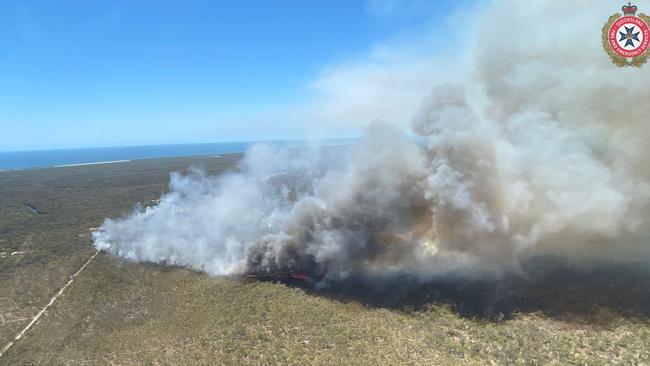
Mr Hines said despite the hot weather, the fire danger across the state on Monday and Tuesday remained moderate because the winds would be weakening, but a number of bushfires continue to burn in the dry conditions.
Residents in the Southern Downs region were on Sunday afternoon warned “conditions could get worse quickly” and they should “prepare to leave”.
Properties between Yankee Gully Road, Hendon Deuchar Road and Upper Wheatvale Road have been told to prepare now so they can leave when the bushfire gets close.
The fire is travelling towards Lawler Road and Upper Wheatvale Road.
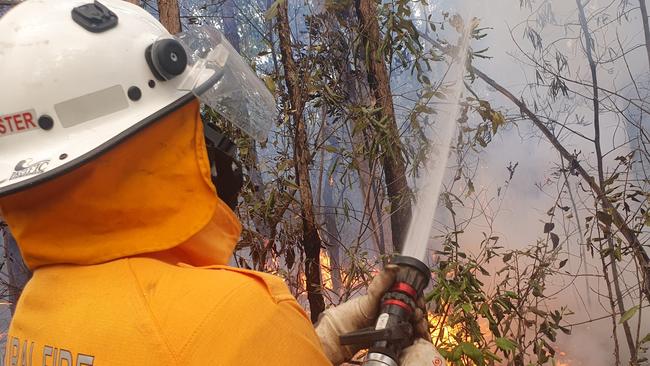
“Firefighters are working to control the fire,” the alert said.
“You should not expect a firefighter at your door. Firefighting aircraft are helping ground crews.”
QFES are telling people to follow their bushfire survival plan if they have one.
“Decide where you and the people you live with will go,” the alert said.
“This could be with family or a friend away from the fire. Plan how you will get there. Tell others where you will go.”
On Sunday afternoon, residents in properties between Cameron Creek Road and Barretts Creek Road including Kenny Road and Rootsey Road at Cooktown were also warned to prepare to leave.
QFES said a slow-moving fire was burning near Cameron Creek Road and conditions could get worse quickly. Other alerts have been issued across the state with residents told to stay informed in Karara, Carnarvon Gorge, Westgrove, Injune, Tallebudgera Valley, and Oakey Creek.
While other areas are being told to stay inside and close windows and doors. These include East Mackay, Gunpowder near Mount Isa, Boyne Island near Gladstone, Hendon near Allora, Thornlands, Cooktown, Beerwah, Mount Alma and Dumaree, Mareeba, Aurukun, Koah near Cairns, Burdell near Townsville, Millstream near Ravenshoe and Moore Park Beach near Bundaberg.
Mr Hines said in the state’s north it would be about two to four degrees above average.
He said Mount Isa was forecast for 39C on Monday and 41C on Tuesday compared to its October average of 34.9C. While Toowoomba was expected to hit 33C compared to it’s average of 24C.
Brisbane was set to reach 31C on Tuesday and 32C on both Monday and Wednesday compared to its average of 27C.
Minimum temperatures in Brisbane were expected to get as high as 23C compared to its average of 16.5C.
“As you get towards that 20 degree mark … you start to be a little bit stuffy overnight, a little bit difficult to sleep when you’re into the 20s,” he said.
However a cool change is expected after Wednesday across the state.
“The temperature will drop away a few degrees, although we will see that wind potentially starting to push a couple of those fire dangers from moderate to high,” he said.
Mr Hines said the South East would be much cooler and could have possible storms as well as showers.
“That kind of weather will stick around for those in the southeast, including Brisbane into Friday and maybe even into the start of the weekend before that activity starts to clear up,” he said.
“But we don’t expect to see that rainfall or at least those showers really spread throughout the state. They’re going to stay fairly confined to southeast.

Ice ice baby: Spectacular images of unseasonal frost as Qld freezes
Queensland’s overnight temperatures will increase to double digits in the coming days, following the coldest start to winter in 16 years, bringing frost and ice to many regions. SEE THE PHOTOS

City’s coldest June start in 16 years, feels like MINUS 9.8C out west
Southeast Queensland is shivering through its coldest morning in more than 15 years but feels-like temperatures have dropped to insane levels in the southern inland.