
Qld ‘on high alert’: Wet fortnight amid cyclone threat, monsoon trough
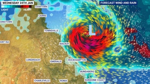
The chance of a severe tropical cyclone forming off the coast of Queensland has continued to rise, with the threat rising to 60 per cent by mid-next week.
QLD weather news
Don't miss out on the headlines from QLD weather news. Followed categories will be added to My News.
The chance of a severe tropical cyclone forming off the coast of Queensland has continued to rise.
Tropical low 05U has been developing in the Coral Sea, well off the Queensland coast, with the Bureau of Meteorology on Monday flagging there was a 25 per cent chance of it escalating into a cyclone next week, before upping it to 40 per cent.
It is now most likely to become a tropical cyclone by Wednesday, when there is a 60 per cent chance of developing.
While the Bureau labelled the system as “extremely unpredictable”, the low is expected to initially track eastwards away from the Queensland coast, but is expected to turn towards the coast from Sunday onwards.
Their tropical cyclone forecast said there was a significant risk that this system may severely impact the Queensland coast during next week.
“Communities on the east coast of Queensland are advised to stay up to date with forecasts and warnings,” it said.
Senior meteorologist Miriam Bradbury on Wednesday said regardless of the outcome of 05U, heavy tropical storms would still threaten Queensland for the next two weeks as the state rides out the delayed monsoon season.
“Whatever these systems do, whether they deepen or not … we’re still in the monsoon season,” Ms Bradbury said.
“Wet weather is still forecast.”
There was a severe thunderstorm warning in place for the North Tropical Coast and Tablelands, Northern Goldfields and Upper Flinders and Peninsula districts on Wednesday night.
The warning said the slow-moving storms, triggered by the monsoon trough, was likely to produce heavy rain that may lead to flash flooding in areas like Mareeba, Mossman, Atherton, Ravenshoe, Julatten and Mount Garnet.
An emergency alert was issued for the Douglas Shire, with the council urging residents to conserve water and cease non-essential water use.
The Queensland Fire and Emergency Services warning said water infrastructure in the area had been affected by recent rainfall, with the reservoir level critically low.
Areas covered by the alert included Whyanbeel, Rocky Point, Wonga and Miallo.
Bureau metrologist Harry Clark said while the cyclone system was weak at the moment, the environment forecast over the weekend was more favourable.
“It is currently sitting in the Coral Sea, east of Cairns and is very weak at the moment but it is drifting slowly towards the east,” Mr Clark said.
“There is no short-term threat to residents but over the weekend the environment is more favourable meaning on Saturday there is a moderate chance of it forming into a tropical cyclone and on Sunday there is then a high chance but we are quite uncertain about the time range at this stage.
“Unfortunately we can’t rule out where it is going and we don’t know if it will come towards the coast or away, the movement is extremely uncertain.
“Of course everyone here is keeping an eye on it and I know Queenslanders are too especially after the severe storms we have seen in the area lately. We just can’t rule out any towns or map where it is going.”
If 05U does develop into a cyclone, it could have catastrophic impacts on the already saturated Far North as it combines with the strong monsoon trough that extends across The Gulf of Carpentaria, Cape York Peninsula, and the Coral Sea.
“Everyone is on high alert across that part of (North) Queensland,” Ms Bradbury said.
“The best case scenario is that it strengthens well offshore.”
A separate tropical low 03U is impacting large parts of the Northern Territory, with widespread storms and heavy rainfall.
Tropical low 03U is expected to continue moving slowly southeast over the next week, reaching inland Western Australia by the weekend.
Ms Bradbury said 03U would not become a tropical cyclone as it will remain over land throughout its life cycle.
Overnight, the highest rainfall totals hit Far North Queensland towns as a result of the tropical low sitting off the coast.
Stewart Creek Valley in the Daintree region saw 151mm in overnight, while Bulgan Creek on the Tully River copped 166mm.
Join the conversation

‘Can’t be ruled out’: Potential for freak Qld snowfall this week
Queensland could see snow this week with weather models predicting up to 14cm falling on the Granite Belt.
Read more

Monster weather system brings storm, heavy rain to Qld
Brisbane and surrounding parts of the southeast have been hit by storms and heavy rainfall this afternoon as a 3000km-long monster low moves across the state.
Read more