
Possible 100mm rain dump, thunderstorms ahead of first week of Ekka show
Thunderstorms and isolated falls of up to 100mm of rain are on the horizon for Queensland, with possible severe weather forecast for a 900km stretch of the state.

QLD weather news
Don't miss out on the headlines from QLD weather news. Followed categories will be added to My News.
Thunderstorms and isolated falls of up to 100mm of rain are on the horizon for Queensland, with possible severe weather forecast for a 900km stretch of the state.
An upper-level trough developing off the Queensland coast could make for a soggy start to the Ekka, which starts on Saturday, with the Bureau of Meteorology confirming some big falls were possible.
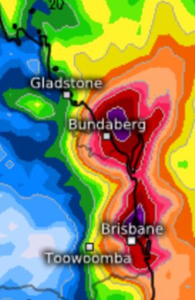
“There could well be a spell for heavier showers and possible thunderstorms for the southern half of the Queensland coast, so anywhere between Mackay and Brisbane at this stage,” the Bureaus Angus Hines said.
“It doesn’t really look to be a widespread weather event, it still looks like the heavier falls will be hit and miss for some spots.”
Mr Hines said the heaviest falls would be most likely closer to the coast as the system enters from the east.
“100mm of rain is probably the higher end of what we are expecting, certainly some spots receiving 50mm is quite possible – there will be quite a range,” Mr Hines said.
He said it was unusual timing. “It’s coming in from the east and usually we are seeing gusty, westerlies — so not a classic case of the ‘Ekka winds’.”
Amateur weather enthusiasts are also predicting big fallsearly next week, with models hinting at totals of 50-100mm with more localised totals of up to 200mm possible across portions of the Sunshine Coast, southeast Queensland and north-eastern New South Wales.
The weekend forecast is expected to bring a few patchy showers to the Queensland coast and cloudy weather.

Hail, rain, wind, SNOW: Winter storm on Qld collision course
A rare winter storm threatens to dump 15cm of snow on Queensland's Granite Belt this weekend as forecasters warn of an incoming polar air mass.

‘Can’t be ruled out’: Potential for freak Qld snowfall this week
Queensland could see snow this week with weather models predicting up to 14cm falling on the Granite Belt.