
Ipswich warned of floods worse than 2022
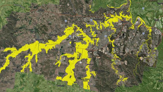
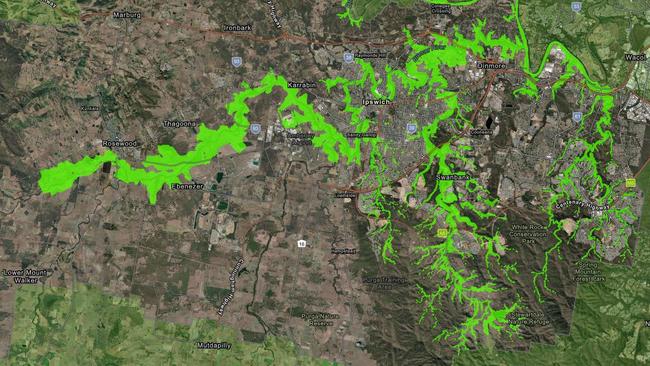
Ipswich residents are warned that potential flooding across the city will be more severe than three years ago as Tropical Cyclone Alfred stalled overnight. SEE THE FLOOD MAP
QLD weather news
Don't miss out on the headlines from QLD weather news. Followed categories will be added to My News.
Ipswich residents are being warned that potential flooding across the city could be more severe than three years ago as tropical cyclone Alfred stalled overnight.
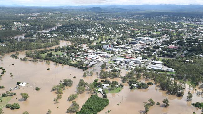
Based on Ipswich City Council’s potential flood model, an area larger than the 2022 flood map is expected to be hit.
The previous flood event caused devastating damages to almost 600 dwellings, 300 businesses and more than 250 vehicles.
Mayor Teresa Harding said the peak for Bremer River was expected to be early Sunday morning, but the level of impacts was still too early to learn.
She urged residents to carefully consider the latest flood modelling to assist with their disaster preparations.
“The modelling shows properties that could potentially be affected by storm surge or flooding,” she said.
“However, residents should note that this may change in the coming days with the changing weather conditions so it’s important to stay up to date as this event unfolds.”
The council has identified two potential evacuation centres, Ipswich Showgrounds and Shiloh Church in Goodna, but none are yet to open.
“Council is ready to activate its evacuation centre locations, should they be required. A decision on whether to open them will be made as the impact of Alfred on our community becomes clear,” a spokesman said in a statement.
“We want to assure the community that evacuation centres have been prepared and are ready to activate quickly if needed. If activated, the evacuation centre should be your last resort.”
While in Brisbane, up to 20,000 properties are warned of their risk of flooding.
Tropical Cyclone Alfred, located about 245km off Brisbane, is expected to bring heavy rainfall, causing moderate to major flooding across southeast Queensland.
The bureau was expecting an accumulated 400 to 800mm rainfall, but its significant impacts were expected well ahead of its landfall.
“But higher isolated falls are possible, as you’ve seen, depending on how that system does move and how quickly or slowly it does move towards the coast,” forecaster Jonathan How said.
It has issued a severe weather warning for heavy and intense rainfall and damaging and destructive winds and a flood watch in the southeast.
Rapid water rises and flash flooding are expected across many creeks, as well as possible widespread minor to major flooding along the lower Brisbane River.
Local Disaster Management Group Chair Councillor Andrew Antoniolli encouraged people living and working along the rivers and creeks to monitor the latest forecast.
“Council has been distributing sand and sandbags from five locations over the past few days. Hopefully these measures will assist in alleviating some of the issues our residents will face with rising water levels,” he said.
“We experienced major floods in February and May 2022 so the impacts and possible devastation are still fresh in our minds.
“The Ipswich community showed tremendous resilience to recover from those floods and I am sure residents will be ready for everything mother nature throws at us again.”

Monster weather system brings storm, heavy rain to Qld
Brisbane and surrounding parts of the southeast have been hit by storms and heavy rainfall this afternoon as a 3000km-long monster low moves across the state.

Wild storms, polar blast as 3000km monster low barrels towards Qld
The system, which stretches 3000km from north to south and encompasses 30 per cent of Australia, is forecast to pack a punch when it hits Queensland.