
Hottest, coldest, windiest, wettest places: Life in Qld’s extreme weather towns
It may be known as the Sunshine State, but Queensland is actually home to some of the most diverse and dynamic weather patterns in Australia, much to people’s surprise. These are our most extreme locations
QLD weather news
Don't miss out on the headlines from QLD weather news. Followed categories will be added to My News.
Snow and UGG Boots are hardly synonymous with the Sunshine State – but Queensland is home to some of the most diverse and dynamic weather patterns in Australia.
From chilly nights in Warwick or Stanthorpe and record-breaking rainfall in the north to the tropical heat of coastal areas and the seemingly endless sun in Thallon – where even the statues need shade sails, Queensland is a fascinating blend of climates.
Whether it’s sudden storms or blue skies, each weather pattern plays a crucial role in shaping the state’s unique ecosystems, lifestyle, and outdoor activities.
This is what it is like for the locals that live in these eight record-breaking locations from across the state who get to experience the best and most extreme of all kinds of weather.

HOTTEST PLACE
Birdsville, Normanton, Kowanyama, Julia Creek
Red dirt, races and the Big Red Bash.
Sitting on the eastern edge of the Simpson Desert, it’s no surprise that Birdsville records the hottest days in Queensland.
This bustling little community, which thrives on tourism, marked its hottest day on record when it hit a whopping 49.5C on December 24, 1972, according to the Bureau of Meteorology.
While that record is still beaten nationally by New South Wales Wilcannia, South Australia’s Oodnadatta and Onslow Airport in Western Australia, which have all reached just over 50C, the heat is no less stifling.
Birdsville is one of the most remote towns in the country, with vast stretches of desert and wilderness surrounding it, making it famous for red, dusty sand dunes.

Located in the remote southwestern corner of Queensland, near the border with South Australia and the Northern Territory, Birdsville is known for its isolated Australian Outback experience and its association with various cultural and sporting events.
Manager of the iconic Birdsville Hotel Ben Fullagar said locals were super resilient people who barely noticed the difference of degrees once temperatures hit above 40C.
“We just say if it’s over 40C it’s hot but it doesn’t matter if it’s 42C or 48C,” he said.
“People have this false idea that we hibernate but it doesn’t change anything, people still go about their days, mowing lawns, operating machinery.
“And there’s no humidity, so you could mow your lawn and not even break a sweat.
“It’s hot, but it’s also not.”
Mr Fullagar said living in Birdsville was exciting, and managing the town’s top congregation spot meant he always met fresh faces.
“Every single day you’ve got that excited face of new tourists who are so happy to be ticking Birdsville off the bucket list,” he said.
“I think (the appeal) is the adventure of being in the Channel Country, right on the edge of the Simpson Desert.”
And while the big annual events were rewarding, Mr Fullagar said visitors who had the opportunity to pass through on a regular day, would experience the true Brisdville.
“The real authentic experience is outside of those major events,” he said.
“For us, the most enjoyment is everyday tourism and people who have the opportunity to have a yarn, see the true relaxed atmosphere of Birdsville.”
The tiny town was founded in the 1880s as a service point for the local cattle industry and as a stopover for travellers, gaining its name after the local Birdsville Station, a large cattle station in the area.
Birdsville has a very small population, with only just over 100 residents but numbers swell significantly during the tourist season.
Despite being the hottest place in the state, wet weather usually seals off road access to Birdsville.
Areas around Gulf Country or North West at Normanton, Kowanyama and Julia Creek have the warmest average temperatures in Queensland throughout the year.

COLDEST PLACE
Warwick, Stanthorpe
It’s a bit of a “shock to the system” when Queenslanders from the coast get to Warwick and realise they need a pair of UGGs to make it through the night in Warwick.
It’s just 130km south west of Brisbane but it’s the coldest place in the state.
Warwick is tied with Stanthorpe as the chilliest place to sleep in Queensland, according to the Bureau, while the Wallangarra Post Office takes the crown for lowest daily maximum average temperature.
The Darling Downs region including Eukey, Ballandean, Stanthorpe and Warwick experience the coolest nights on average each year.
Warwick holds the record for coldest temperature at -10.6C on July 12, 1965.

With a town of 12,300 people, Warwick locals have become accustomed to contrasting cool nights and warm daytime temperatures.
But visitors often flock to Rosewool Uggs and Rugs, with owner Tony Gilchrist who says he tries to do his part keeping the people warm.
“Especially those coming from a coastal area where it‘s warm at night, it is a bit of a shock to the system when they come this way and they need ugg boots,” he said.
Mr Gilchrist said locals are used to the weather whiplash with Warwick temperatures climbing several degrees in the space of one day.
“Once the sun goes down you feel it cool off pretty quickly,” he said.
“We also have frost in the mornings, you look at the temperature of in your phone and its getting up to 30C but its 5C in the morning.”
The shop sells top quality skins and wools and Mr Gilchrist says visitors often call in on their way through to Stanthorpe, known for its excellent wineries.

Warwick was originally established as a European settlement in 1847 and quickly became an important centre for agriculture and commerce in the Darling Downs region.
It was named after Warwick, England.
Famous features include the Warwick Jumpers and Jazz in July Festival, and Stanthorpe’s excellent wine and fresh produce.
As for Mr Gilchrist, he doesn’t mind the cold. Born and bred in Warwick, the lifestyle is in his blood. His wool business, he says, is “something I got stuck with”.
“The sheep industry is not what it used to be, wool is struggling, but a lot of people do find me from google as they go through town and I’ve got a reputation for being one of the cheaper retailers.”
SUNNIEST PLACE
Thallon, Daymar
Thallon and Daymar boast the sunniest days in Queensland, or the most sunshine duration compared to elsewhere in the state.
Located in the Darling Downs region near the border with New South Wales, Thallon has a small population of around 231 residents. and Daymar, just 41 residents.
Thallon is a small rural town known for its agricultural activities, iconic silo art, and close-knit community.
But resident Leanne Brosnan, who owns the Thallon Francis Hotel, says a small doesn’t necessarily mean a quiet town.
In fact, with the peak of the pandemic now in the rearview mirror, it’s bustling and filled with wonderfully friendly people who always looked out for each other.
“They are wonderful people with wonderful attitudes and we always seem to get through tough times together,” she said.
“It’s a lovely town where everyone is included and feels safe.
“Find us just north of where the straight line meets the bumpy line on the Queensland border.”
Thallon offers a glimpse into the rural way of life in Australia and has become a unique stop for travellers interested in exploring the country‘s lesser-known destinations.
One of the most well-known landmarks in Thallon is the GrainCorp Silos.

The grain silos have been transformed into a stunning work of art as part of the Australian Silo Art Trail and remain a significant drawcard to the area, with the stunning designs created by “The Zookeeper” Joel Fergie.
The vibrant local flora and fauna, including a barking owl and a kookaburra splashed on the huge silos have also become a symbol of community pride in Thallon.

Sunny Thallon is also home to a big northern hairy-nosed wombat called William but, due to the extreme sun exposure the town receives, a shade sail had to be constructed over William to keep him cool -and to protect the hands of visitors who pat him.
“We have some great local characters too but you’ll have to come to Thallon to meet them,” Ms Brosnan said.
“Unfortunately it was too sunny from 2013 – 2020 with very little rain in that period.
“2022 was one of the wettest years on record and then in 2023 the tap has turned off again so a bit less sunshine at the moment would be good.”

SNOWIEST PLACE
Girraween, Eukey, Ballandean
Areas in the Southern Darling Downs are by far the snowiest places in the state.
For those planning a trip to see fresh white powder in person, Girraween, Eukey and Ballandean are the safest bets for next winter.
Populations are very small in the region, with only five Girraween residents, 140 Eukey residents and 316 Ballandean residents, according to the latest census data.
Girraween National Park is situated in the southern part of Queensland, near the border with New South Wales, approximately 260 kilometres southwest of Brisbane and covers an area of about 30,000 acres.
The park‘s most famous rock formation is known as “The Pyramid,” a large granite peak that can be hiked. Other notable rock formations include the “Sphinx,” ”Turtle Rock,” and ”Balancing Rock.”

The park’s landscape is characterised by massive granite outcrops and boulders, making it a popular destination for rock climbing, hiking, and photography.
Manager of the Girraween Lodge Paul Mengotti said the area was full of wildlife and “the most spectacular granite rock formation”.
“The weather is amazing, we have four seasons of European weather,” he said.
“Summers are very comfy, humidity free as we are almost 1000 metres high on the mountain.”
Mr Mengotti said the last heavy snow season in Girraween was in 2015, but the area still experienced frosty and misty mornings.
“During the late autumn and winter, which creates very magical scenery and a wonderful snowy look,” he said.
“Hikes are also extremely popular here. We have got our own private tracks, but we are also adjacent to the Girraween National Park.”

Sitting just above Girraween National Park is the small town of Eukey and a further 8 kilometres north is Stanthorpe.
Eukey, like the broader Granite Belt area, experiences a cool temperate climate and cold winters.
WINDIEST PLACE
Hamilton Island
Hamilton Island is one of the most popular tourist destinations in Australia, known for its stunning natural beauty and a wide range of activities and amenities – but it’s also known for blowing a gale.
A record wind gust of 263km/hr was recorded at Hamilton Island from severe tropical cyclone Debbie in 2017.
Part of the Great Barrier Reef Marine Park, Hamilton has a residency population of about 1,800 and is situated approximately 887 kilometres north of Brisbane but is easily accessible with its own airport.

Covered in lush tropical flora and surrounded by sandy beaches, the largest inhabited island in the covers an area of about 5.6 square kilometres.
Sailing Whitsundays employee Talia Jones said the wind makes it the perfect place for her proffered activity and working on the island feels like a never-ending holiday.
“Waking up to blue skies, palm trees and warm weather with ocean views of turquoise water and the surrounding Whitsunday Islands to marvel at every day is absolute bliss,” she said.
“The moment you step foot on Hamilton you're hit with the warm, island breeze which instantly sets that feel-good mood.
“So many people from around the world visit with the intention of staying for a few days, weeks, or months, but the year-round summer feeling is addictive and magically convinces people to stay.

“Most of my friends, myself included, were only intending to be in the Whitsundays for a short period of time, and now a few years have passed. It’s too good to leave.”
While a hugely popular tourist spot, Hamilton Island promotes eco-friendly tourism and sustainability initiatives to minimise its impact on the fragile marine ecosystem of the Great Barrier Reef.
The Whitsundays have also been a chosen destination for several Hollywood films including Pirates of the Caribbean: Dead Man Tell No Tales, Fools Gold, Spiderhead, and most recently, Ticket to Paradise.
Hamilton Island, like much of the Queensland coast, is affected by trade winds which typically blow from the southeast and can bring a consistent breeze to the island, with stronger more notable winds blowing during summer months.

Ms Jones said the winds were a “huge drawcard” for boat and sailing lovers.
“Being able to jump on a boat and within 30 minutes be in among the 74 Whitsunday Islands that surround us is a huge drawcard,” she said.
“The sailing culture is massive in the area and sailing is the best way to take advantage of strong winds.
“Any keen sailor will jump at any opportunity to get the sails up – and there’s no better feeling than switching off the engine and hearing the sails in the wind.”
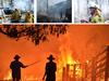
When Cyclone Debbie struck on March 28, 2017, it was regarded as one of the most significant weather events in Queensland history.
Travelling westward and rapidly intensified into a Category 4 tropical cyclone, Debbie reached wind speeds exceeding 200 kilometres per hour.
Cyclone Debbie made landfall near the town of Airlie Beach and continued to move inland, causing devastating widespread damage across a large part of Queensland and northern New South Wales.
“Staying aware and informed is important to locals who live here, especially knowing where to go in the event of a cyclone,” Ms Jones said.
“People usually clear up their yards to ensure loose items aren’t left outside, board up windows if the wind is predicted to be severe, park their cars undercover and try to remain inside.
“Boat owners bring their boats into the marinas and sail boats would strip their sails to prevent any damage. “The local community is small but it’s amazing to see how people come together during cyclones or bad weather events to help one another.”
WETTEST PLACE
Babinda, Innisfail
Several areas are in hot competition for the title of Queensland’s wettest place.
Crohamhurst in the Sunshine Coast holds an Australia-wide record for the most amount of rainfall in a single day, after 907mm fell on February 3, 1893.
But Bellenden Ker holds the records for the highest monthly rainfall and highest annual rainfall in Australia.
In January 1979, Bellenden Ker experienced 5,387mm and throughout 2000, a total 12,461mm fell in the area.
Bellenden Ker records heavily outweigh second place measurements of only 1620mm during one month and 4998mm during a single year.

South of Bellenden Ker is Queensland’s tied top spot for highest average rainfall, Babinda.
With a population of about 4,500, Babinda is a picturesque small town located in Far North Queensland.
It may be wet, but that’s exactly why Babinda Kool Spot Cafe owner Lorraine Deal lives there.
“The town never floods, it always subsides within a couple of days,” she said.
“The town is absolutely beautiful with the rainforest, hills, trees, mist, fog, mountains, clouds, the fresh running water.
“You get everyone going out to the boulders, there are tourists there all the time, locals as well, and so many swimming holes.”
It is renowned for its natural beauty, rainforest surroundings, and proximity to some of the region's most stunning natural attractions.
Situated approximately 60 kilometres south of Cairns, it’s part of the Cairns Highlands, an area known for its lush tropical rainforests and stunning landscapes, Babinda is often referred to as the “Town of Babinda Boulders.”
The boulders are a set of large, smooth granite rocks located in the Babinda Creek, a popular watering hole used by visitors and locals to cool off.
Like much of Far North Queensland, Babinda experiences a tropical climate with high humidity and warm temperatures year-round.
The region also receives a significant amount of rainfall, particularly during the wet season, about 4280mm per year.

Ms Deal said rainfall also didn’t ruin the Babinda experience, with businesses always open and accessible.
“A lot of people think cause its raining, let's not go there, but then you see the rushing water at the boulders, which is another beautiful thing, you’ve got to see the beauty of it,” she said.
“You can still sit in the Kool Spot cafe and watch the rainfall.
“Don’t be scared of the rain, just buy an umbrella.”
Just south of Babinda is the Tropical North Queensland town Innisfail -another strong contender for wettest place in the state.
Known for its lush tropical rainforests, agricultural activities, and proximity to the Great Barrier Reef, Innisfail is approximately 88 kilometres south of Cairns and sits along the banks of the Johnstone River.
With a population of about 2000, Innisfail receives rainfall throughout the entire year, meaning there is no distinct dry season.
The wettest period typically occurs during the Australian summer monsoon season from December to March with the town receiving an average annual rainfall of approximately 3,000 to 4,000mm.
Local Brenton Gangemi, who operates wildlife and river cruise Snapping Tours, said Innisfail was “green like you have never seen” with major “tropic vibes”.

“Our town is known for its beautiful greenery, wonderful waterfalls, and awesome beaches,” he said.
“It’s a beautiful place with a great community spirit and the scenery is absolutely picturesque, all thanks to the rain we receive.
“Often when people ask “where is Innisfail?” and the most common answer is that we are a town near Cairns. “However, sometimes we may mention that we were the town that was hit by Cyclone Larry, to which many people have a better idea of where our little town is located, as we did receive quite a large coverage on TV during this time.”
Category 5 Cyclone Larry hit Innisfail in 2006, followed by Cyclone Yasi in 2011.
Both caused significant damage to the town and its infrastructure however, the community is extremely resilient and quickly rebuilt and recovered.
Established in the late 19th century, Innisfail was named after Innisfallen, an island in Ireland‘s Lakes of Killarney.
The town developed primarily as a centre for the sugar cane industry, and sugar farming remains a significant part of the local economy, with Innisfail also famous for its delicious bananas.
Innisfail is often referred to as the “Gateway to the Great Green Way” due to its location at the southern entrance of the Wet Tropics World Heritage Area.
“We are also known as the Art Deco Capital of Australia,” Mr Gangemi said.

“We are lucky to have many scenic attractions that make getting out and about so worthwhile but it can get pretty hot here in summer.
“Although Innisfail receives heavy rainfall each year, I don’t know if we can yet be titled the wettest place in Queensland.
“A little town south of us called Tully may just be in the lead. After all, they still hold the iconic Golden Gumboot.”
DRIEST PLACE
Bulloo Downs
From one side of the coin to the other – the driest place in Queensland with least amount of rainfall is the Bulloo Downs, a cattle station located in the Shire of Bulloo tucked nicely into the south west pocket of the state nearly 800km south of Roma and more than 1,100km west of Brisbane.
While the cattle station is unpopulated, surrounding towns also share similar dry weather conditions like Durham, Quilpie Eromanga and Thargomindah.
Quilpie resident Roger Volz said the hot dry weather was just “part of the whole experience”.
“That's why we have airconditioning and pools, or we sit down on the banks of the river and go for a swim,” he said.
Mr Volz, who is a member of the rural fire service and frequently travels through Durham and Thargomindah said the area traditionally didn’t experience fire due to lack of fuel loads.

“Out here a lot of our vegetation is dispersed,” he said.
“While we might get a fire, generally, it doesn't keep burning like ones out south.”
He said it was “very dry” at the moment, with nearby farmers now losing feed due to it losing nourishment in the dry weather.
“They’re now supplementing their feeds with lick blocks- some people are moving into that space now,” Mr Volz said.
While nearby communities were experiencing population decline, Mr Volz said Quiplie was experiencing a mini boom from Queenslanders wanting to live the country life.
He said the best thing about Bulloo Shire was its authenticity and “the sounds of the bush”.

“Out at Adavale, township was the main shire base back in the late 1800s but when the railway moved here in 1917, it got put to Quilpie, people moved down here,” he said.
“I don’t think there are any rentals left in town.
“People building out here more. I think it’s all about the lifestyle and the fact that you can just go 1km out of town and you’re in the bush and away from the lights.
“In the smaller towns, you get to see the sunrise and the sunset.”
STICKIEST PLACE
Weipa, Cairns, Mackay
When it comes to the stickiest place in Queensland, several coastal areas tie for having the most humid conditions.
Top contenders include Weipa, Cairns, and Mackay, where humidity levels sit about 50 per cent for a majority of the year.
In Weipa, February is usually the most humid month, at an average 81 per cent, but the town is experiencing a strong 65 per cent average humidity level all year round.
The month for lowest humidity is October when it drops to about 50 per cent.
Located just south of Duyfken Point in Far North Queensland in the western coast of The Cape York Peninsula, overlooking The Gulf of Carpentaria, Weipa is a fairly new town with just over 4000 residents.
It is known for its rich minerals and is home to one of the world’s largest bauxite mining operations – the primary source of aluminium.
Weipa experiences a tropical climate with distinct wet and dry seasons. The wet season typically occurs from November to April, with heavy rainfall and high humidity. The dry season, from May to October, brings milder temperatures and less rainfall.
Weipa Bowls Club secretary Karen Phillips said humidity does little to dampen the spirits of the local, with the best thing about the town was the sense of community.
“Everyone looks out for each other and their dogs, our local Facebook page “Secrets of Weipa” always has a post showing dogs out and about when they happen to escape their yards, and almost always, someone will say ‘Oh that’s so and so’s dog/s,’” she said.
“But seriously, whenever a member of the community is in need of assistance, there are no shortage of hands or supporters to help out, even to the extent of fundraising.”
The small remote mining town is sparse for shops and while Ms Phillips says it might not have “everything you want” it still has “everything you need”.
“The downside of living where we are is that prices are sometimes higher than in other areas, especially for some food items, fuel and alcohol, but we all get by.
“It is also hard to get accommodation here, and rent prices are quite high for what you get.”
Much of the surrounding land around the township was leased to the mining company Rio Tinto, which operates the mammoth bauxite mining operations and is a huge economic driver for the town.
Rio Tinto Weipa is a major contributor to the regional economy, making significant investments in local infrastructure with the mined Bauxite used to make aluminium.
“Weipa town itself is only just over 50 years old,” Ms Phillips said.
“It does get quite humid here especially during the wet season, but I was out recently on the Mid North Coast of New South Wales, where I used to live, and I find the weather is comparable.
“Temperatures vary – we really don’t have a winter as such, yes it gets a little cooler, minimum say 16-18C overnight, but it soon warms up to the high 20s low 30s and is quite pleasant.”
The Weipa wet season runs from January to April, followed by a dry season from May to September.
“In late spring is “build up season” and this is when it is hottest and most humid with temps often over 35C daily and we all anxiously await the first good downpour and thunderstorm of the season,” Ms Phillips said.


Ice ice baby: Spectacular images of unseasonal frost as Qld freezes
Queensland’s overnight temperatures will increase to double digits in the coming days, following the coldest start to winter in 16 years, bringing frost and ice to many regions. SEE THE PHOTOS

City’s coldest June start in 16 years, feels like MINUS 9.8C out west
Southeast Queensland is shivering through its coldest morning in more than 15 years but feels-like temperatures have dropped to insane levels in the southern inland.