
Heatwave for western Queensland as rest of the state braces for storms, possible tropical cyclone
Parts of central Queensland sweltered through more extreme heat today ahead of predicted severe thunderstorms and heavy rain over the next 48 hours, and another possible tropical cyclone on the way next week.

QLD weather news
Don't miss out on the headlines from QLD weather news. Followed categories will be added to My News.
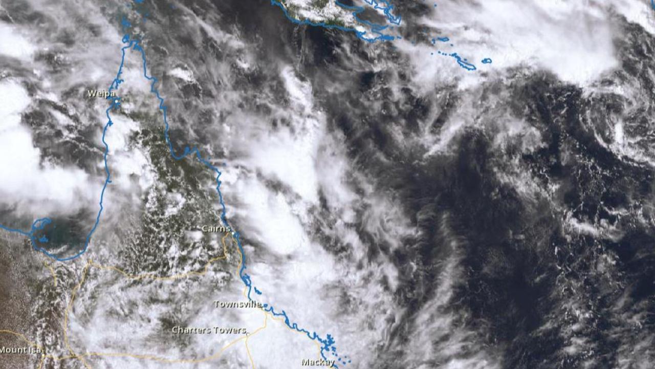
Meteorologists say another tropical low to develop in the Coral Sea is has a moderate chance of becoming a cyclone and is likely to bring storms to Queensland next week.
BOM meteorologist Shane Kennedy said the low was expected to develop in the north west of the sea over the weekend and may move into the Gulf of Carpentaria next week, drawing the monsoon trough down over northern Queensland.
“This system has a moderate chance of developing into a tropical cyclone next week,” Mr Kennedy said.
“This activity is likely to increase showers and thunderstorms across the north and northeast, starting from Sunday but particularly over Monday and Tuesday as the monsoon trough is dragged over northern Queensland.”
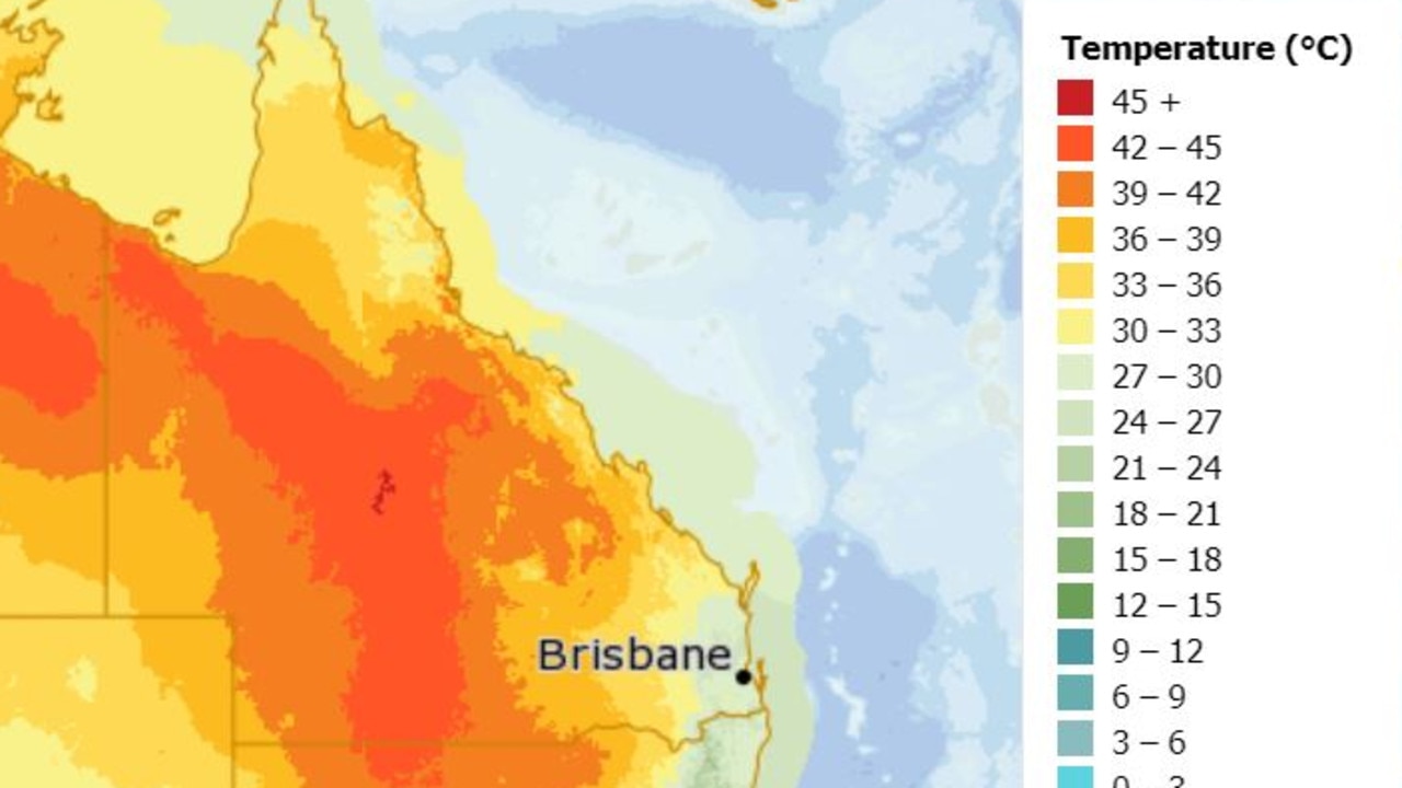
Extreme heatwave conditions experienced in central Queensland this week are expected to move to the state’s west where temperatures will remain above 40C for several days.
Temperatures should ease in eastern and northern Queensland with showers and thunderstorms forecast.
Mr Kennedy said severe thunderstorms with heavy rainfall were possible between Rockhampton and the Sunshine Coast on Friday as ex-tropical cyclone Seth comes ashore and weakens.
“With scattered totals of 50mm to 120mm possible over the next day,” he said.
The southern interior could also experience damaging wind gusts and severe thunderstorms on Friday.
Mr Kennedy said showers and storms could increase over South East Queensland next week with an active monsoon flow into the Coral Sea.
Residual flooding is likely to persist in state’s south over the next few days while strong wind warnings over southeastern waters will gradually ease throughout Friday.
Temperatures on Thursday soared towards 40C before 11.40am as a heatwave grips parts of Queensland.
Blackall, at 41.6C, was the hottest place in Queensland at 11.40am while the apparent temperature reached a searing 40.7C at Longreach.
Winton recorded 39.2C at 11.40am, while Charleville had reached 38.7C.
Those centres are now even hotter, with the mercuy hitting 43.6C at Longreach about 1.30pm.
It was not much cooler at Blackall on 43.1C.
The Bureau of Meteorology has forecast temperatures across much of central Queensland to climb between 42-45C with some towns expected to reach the high 40s.
TEMPERATURES AT 11.40AM
Blackall – 41.6C
Longreach – 40.7C
Winton – 39.2C
Charleville – 38.7C
Innisfail – 35.5C
Cairns – 36.9C
Townsville – 35.5C
Goondiwindi – 32.7C
Ipswich – 30C
Bundaberg – 29.7C
Brisbane – 29.7C
Gold Coast – 27C
Temperatures should be cooler for the southeast and the bureau has forecast temperatures easing across the state for the weekend as ex-Tropical Cyclone Seth drifts northwest.
Meanwhile, large parts of Queensland have been warned to brace for severe thunderstorms with heavy rainfall today.
There’s a high chance of showers for South East Queensland as the low nears the coast.
Up to 25mm of rain is expected in Brisbane today, and up to 50mm on Friday.
Similar rainfall is forecast for the Gold Coast while up to 70mm of rain is expected for the Sunshine Coast on Friday.

Search for man missing in flood waters as NQ faces another 300mm monster
A search and rescue mission is underway in NQ for a man who drove into flood waters while the region braces for an active monsoon trough expected to dump falls of up to 300mm.
Read more
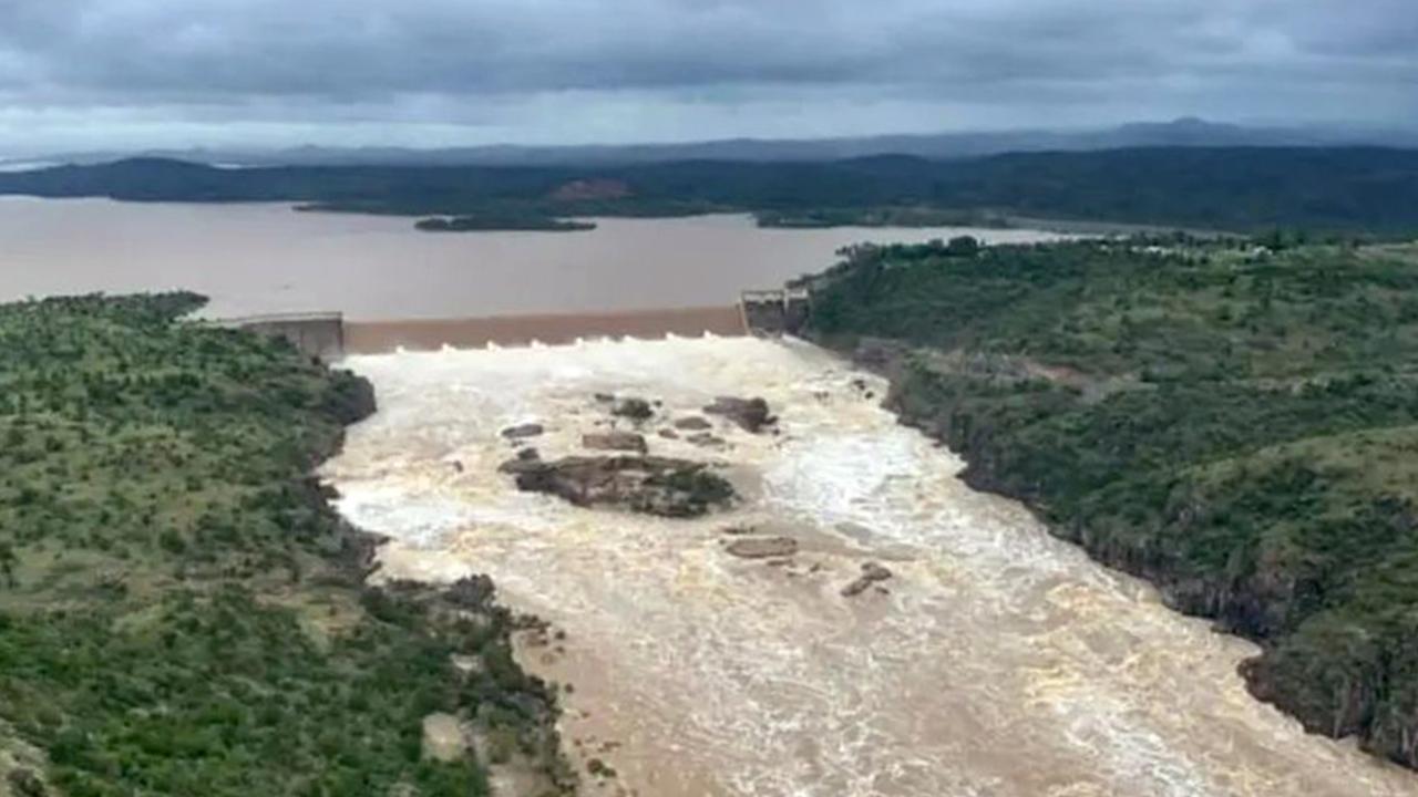
New emergency alert as Far North braces for second coming of biblical flood
A second deluge of up to 300mm is set to pound Far North Queensland, with flood warnings for half a dozen rivers and more than 140mm of rain recorded overnight in some parts.
Read more