
Extreme weather: Severe storms, heatwave after 100+mm rain, hail dump
Darling Downs businesses have been left mopping up after ferocious storms brought in heavy rainfall and lots of hail overnight. The extreme weather is set to continue with more storms forecast, plus a heatwave.

QLD weather news
Don't miss out on the headlines from QLD weather news. Followed categories will be added to My News.
Businesses owners across Toowoomba spent their Sunday cleaning up following an overnight storm which dumped an incredible amount of hail.
Design business Black Canvas posted to social media that half a metre of hail blanketed its garage this morning.


Proof BBQ and Booze’s Toowoomba store was forced to close on Sunday after the building flooded and ceilings fell and exposed electrical.
Toowoomba Coffee House staff joked that they could make frappes with the ice that covered the cafe’s courtyard.
SCROLL DOWN TO SEE THE FORECAST FOR TODAY AND THE WEEK AHEAD

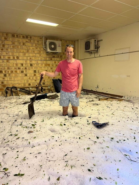
The storm managed to fill closed garages with hail as wind and rain pushed in roller doors.
Darren Fielder from Redleaf Environmental suspected the flood-prone garage of his consulting firm may have suffered some damage when he saw early reports of damage across Toowoomba.

“Because it was such a strong storm cell over the CBD of Toowoomba... a lot of rain within a short amount of time, plus the hail, ran down the street and the weight pushed in the doors,” Mr Fielder said.
“It damaged all the garage doors.
“The flood water would back out of there again but the hail was just left there.”

Travis Fielder and Dan Heaton stood knee deep in hail at the firm’s garage as they began to shovel the hail away.
Mr Fielder said he was one of many business owners dealing with damage on Sunday.
“I’ve spoken to others who had the weight of the hail push through their ceiling and damage their offices,” he said.

Heavy rain was recorded from the southern interior right to the Gold Coast and residents in Toowoomba woke to fallen trees, damaged buildings and leaking ceilings.
Benita Taylor, from Toowoomba City, woke to the sound of heavy rain and hail about 2am.
When she checked her rain gauge later on Sunday, it revealed the wild storm dumped 104mm on her property.

“The leaves of my hydrangeas had holes in them from the hail, a big branch had fallen from our Silky Oak and our neighbour’s arbour had been pushed down,” she said.
“So it was quite a heavy thunderstorm.”
The Bureau of Meteorology recorded 31mm falling on the Gold Coast seaway in the 24 hours to 9am, 29mm at Texas, and 28mm for Applethorpe.
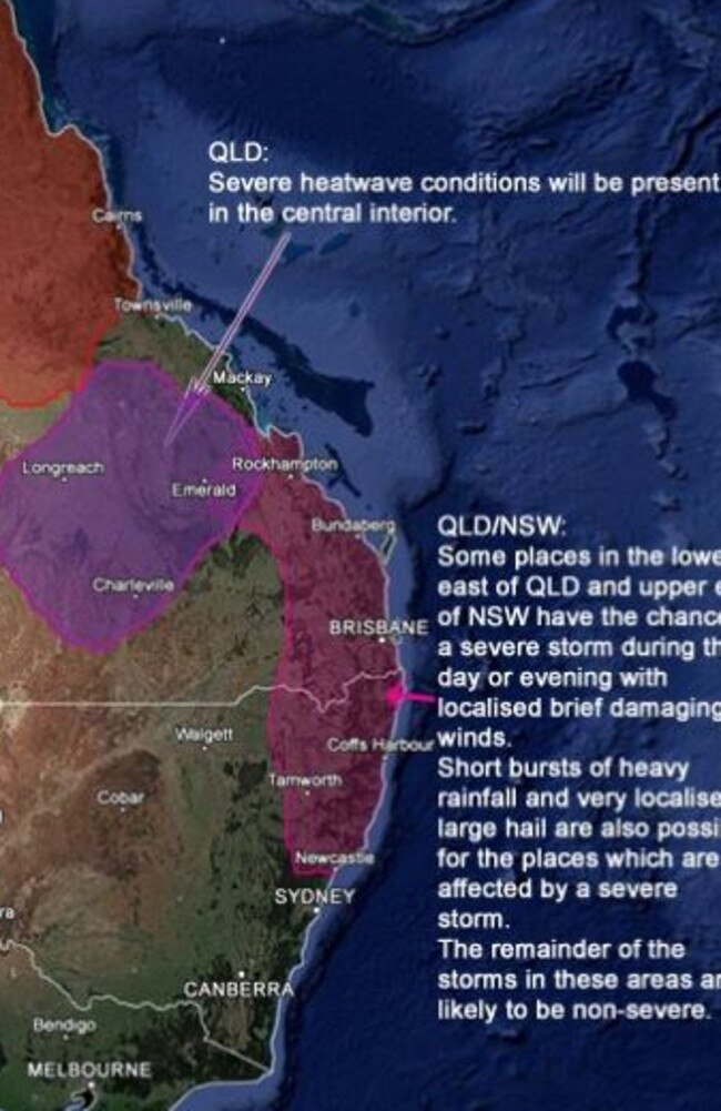
The extreme weather is expected to continue across Queensland today with meteorologists forecasting heatwaves and severe storms.
The Early Warning Network forecast possible severe storms across South East Queensland during Sunday and into the evening.
The network warned some places could be impacted by brief and localised damaging winds.
“Short bursts of heavy rainfall and very localised large hail are also possible for the places which are affected by a severe storm,” the forecast stated.
Severe heatwave conditions are expected through the central interior and could impact Longreach, Charleville and Emerald.
The state’s north could be impacted by a scattering of non-severe storms throughout the day.
The network advised that storm activity was likely in areas from Mt Isa to Weipa and Townsville.
BOM meteorologist Steven Hadley said storms this evening were mostly likely to hit farther north than they did on Saturday night.
He said it was also unlikely the storms would be as severe.
“The Wide bay potentially - so Dalby, Kingaroy, and Gayndah is where there would be the most obvious risk today,” Mr Hadley said.
An earlier tsunami warning for coastal areas following a volcano off Tonga has been cancelled but warnings for rough surf remain and several beaches have been closed.
Mr Hadley said the bureau would keep a close watch on activity in the Pacific Ocean following the eruption.
Fiji Airways advised that several flights to and from Australia’s east Coast had been impacted by ash cloud from the eruption.
Flight FJ921 from Nadi to Brisbane was given a new departure time of 12pm while departing Flight FJ920 to Nadi was cancelled and pending a reschedule.
Flights from Sydney and Melbourne have also been rescheduled.

Meanwhile, a slow-moving low pressure trough over south-west Queensland is expected to bring rain for the west of the state from the middle of the week.
Mr Hadley said shower activity was also on the cards for the southeast.
Residents in other parts of the state can expect to swelter through the beginning of the week with heatwave conditions to remain for central Queensland.
“Places including Mackay and Townsville as well, even on the coast, could see those heatwave conditions over the next few days,” Mr Hadley said.
“It begins to subside later in the week so hopefully the trend is for that heatwave to ease off a bit through the week.”
In the state’s north, just the usual summer storm and shower activity can be expected with a very low risk of a tropical cyclone forming.
Mr Hadley said Cairns and the Tablelands could see showers through the week, while Cape York and Mt Isa could be hit with storms and showers.
“It is relatively benign, usual wet season weather,” he said.

‘Too slow, no data’: Major BOM failures exposed in damning new report
Qld residents were forced to rely on amateur storm chasers instead of the weather bureau which failed to predict and alert the state during natural disasters, a new report has revealed.
Read more
PM slams Bruce Hwy, as military might unleashed on flood clean-up
The Prime Minister hasn’t pulled any punches in his assessment of a critical part of the Bruce Highway as he visits flood-ragaved North Queensland, vowing to provide “whatever support is necessary”.
Read more