
Experts reveal what they think will happen when Tropical Cyclone Alfred makes landfall
With so much uncertainty over Tropical Cyclone Alfred’s impact once it makes landfall, we went to four experts. They all agree on one confronting scenario.

QLD weather news
Don't miss out on the headlines from QLD weather news. Followed categories will be added to My News.
Tropical Cyclone Alfred will turn towards South East Queensland with landfall as a category 2 system expected about 7am Friday.
While many questions remain over its impact, four experts we spoke to all agree on one key scenario – it will bring widespread rainfall and a massive storm surge, with the potential for widespread flooding.
Here is what the experts had to say:
Dean Narramore
The Bureau of Meteorology
Senior meteorologist Dean Narramore said the system, which was sitting 560km east of Brisbane, would begin tracking west towards South East Queensland on Wednesday afternoon.
“Now at this stage, we have it crossing as a category two system to the north of Brisbane, around the Caloundra area.
“What is important to note is that the impacts are going to be felt well away from where it crosses, particularly to the south.
“So of course, we could see some of the worst conditions, not only around Caloundra south of the Sunshine Coast, but also through Brisbane and the Gold Coast as well,” Mr Narramore said.
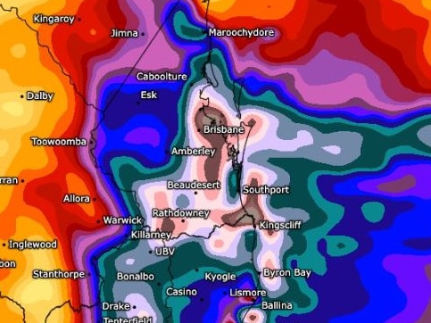
He said those areas in particular would see heavy rainfall which could lead to widespread flooding, with falls of 200-400mm likely, and excess of half a metre of rain in some isolated areas.
■ What should I pack? What about pets? Cyclone safety guide
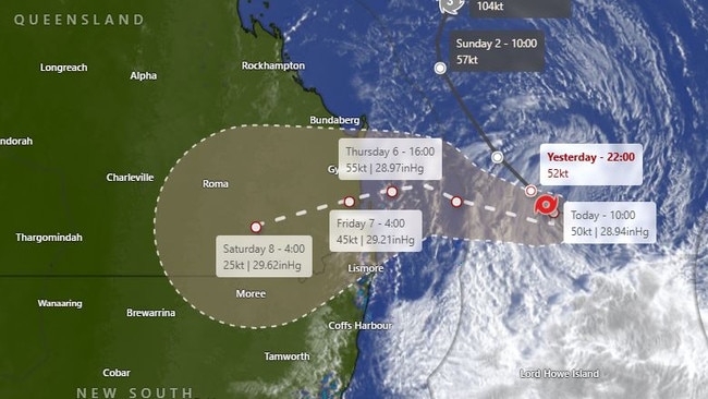
The tide could also exceed the highest astronomical tide of the year by at least a metre, possibly even higher, according to Mr Narramore.
Despite tracking expected to “wobble” in terms of landfall, it is very likely that Brisbane and the Gold Coast would see the worst conditions.
“We’re still looking at very weak, very wet and windy conditions to the Sunshine Coast,” Mr Narramore said.
“The winds generally will be coming kind of offshore, but still we see gusts up there, 60-80kmh, if not higher than that.
“Further south, we could see just hours upon hours of not only the really strong winds, and particularly damaging winds in excess of 100kmh, but also that widespread heavy rainfall, particularly as you get even further south towards even the Gold Coast and the southern parts of the south east coast.”
Thomas Hinterdorfer
Higgins Storm Chasing
Higgins Storm Chasing frontman Thomas Hinterdorfer warned Brisbane and Gold Coast residents to brace for the worst conditions, with some areas potentially copping up to a metre of rain by the end of the week.
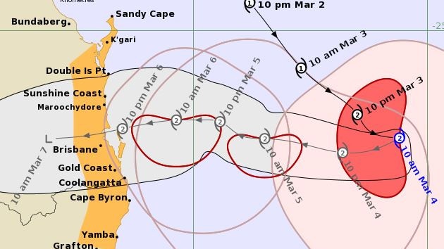
“Tracking is still suggesting that landfall is expected overnight, Thursday night into Friday morning, probably closer to that midnight time frame. As far as we’re concerned, landfall is still expected to be between Brisbane and the Sunshine Coast,” Mr Hinterdorfer said.
“At the moment, I’ve got it around Caboolture, Deception Bay, but in the big picture … we’re still within about half an hour of each other with those tracks and that could end up being just the size of the eye at the end of the day.”
Mr Hinterdorfer said the “relentless heavy rain”, as well as the destructive winds, would fall south of the system and extend well into New South Wales, warning of widespread falls of 300-600mm and isolated falls of up to 1000mm.
“At this stage, it’s pretty much locked in that the Northern Rivers of New South Wales, Gold Coast, Scenic Rim, Ipswich, Brisbane, Locker Valley and the general Caboolture area are all expected to see prolonged, significant impacts, mainly around those damaging to destructive winds and the torrential rainfall.
“The strongest winds with this system will be very close to the centre when it makes landfall, but the damaging winds and locally destructive winds are expected to extend quite a distance from the system,” he said.
Mr Hinterdorfer predicted the heavy rain was expected to start Thursday and persist through to at least Saturday
“Even when the system’s gone inland into the Darling Downs, the north-easterly winds that will feed in behind it are still going to be quite strong.
“We’re still going to see like 60, 70, 80, maybe even 90 or 100km/h winds over coastal areas on Saturday and Sunday with continued rain through those periods.
“Saturday and Sunday will not be as bad as Thursday and Friday, but it will significantly slow down the recovery process,” he said.”
Dr Tom Mortlock
Head of Climate Analytics Asia-Pacific at Aon
Dr Tom Mortlock agreed the system was likely to cross between Brisbane and the Sunshine Coast, bringing a storm surge and coastal flooding.
“The track at the moment is for landfall just north of Brisbane, but it’s on the southern flank of an east coast tropical cyclone is where you get the onshore directed winds, and that’s often where you get the most damage in terms of coastal flood impact.
“So really, whether the cyclone’s landfall coincides with the high tide is going to be the big determinant on the coastal erosion and flooding impacts that we may get across South East Queensland,” Dr Mortlock said.
He went on to suggest flood impacts were “certainly” going to be a feature of the event, with some forecasts predicting between 600 and 700mm rain.
“Those flood impacts from river systems and flash flooding can linger for days and sometimes even weeks after the cyclone has made landfall and has been downgraded to a tropical storm.
“We’ve seen that in many cases of historical tropical cyclone events where it has rained out on inland parts of the catchments, and then it takes several days for that flood – that flood wave – to make its way down the river systems,” Dr Mortlock.
Alison Osborne
Sky News Meteorologist
Sky News meteorologist Alison Osborne said while heavy rain and wind was certainly a big factor, the storm surge was a major concern looking forward – including the unpredictability of the high tide.
“My biggest concern for residents is the threat of a storm surge, because let’s face it, South East Queensland, northeastern New South Wales, they’ve seen weather events of a similar magnitude in terms of wind and rain,” Ms Osborne said.
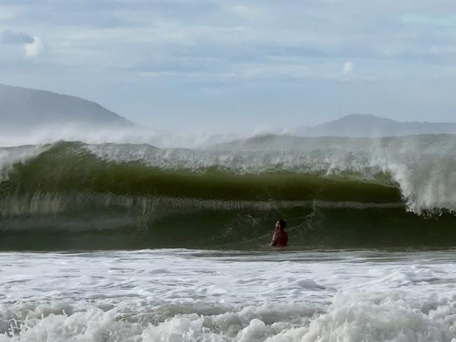
“It’s the waves, so we’re looking at wave heights peaking on Wednesday evening at between eight and 10 metres within the surf zone, so when that comes in, it will swallow beaches. “
She went on to say this would likely cause minor flooding to areas adjacent to the beach, resulting in dangerous conditions on the roads.
Ms Osborne also agreed Brisbane and the Gold Coast would feel the effects of Alfred the most.
“On the southern flank of a system like this, we generally see the strongest winds, heaviest rain and also the largest waves,” Ms Osborne said.
“Between now and probably the weekend, we’re looking at falls between 500 and 700mm across that region, so south of the Sunshine Coast, and then towards Port Macquarie in New South Wales.
“So that’s, fairly comparable to a number of weather events we’ve seen in this part of the country, even this decade, and it’s nowhere near that of say, the 2022 floods, but it’s still enough to cause flash flooding, and potentially some river rises as well.”
Ms Osborne said the heaviest falls would be on Friday for around 24 hours, with rain increasing from Wednesday evening onwards.
Wind gusts of up 90km/h are set to occur from Thursday with gusts of upwards of 120km/h as the cyclone crosses early Friday morning.

Monster weather system brings storm, heavy rain to Qld
Brisbane and surrounding parts of the southeast have been hit by storms and heavy rainfall this afternoon as a 3000km-long monster low moves across the state.

Wild storms, polar blast as 3000km monster low barrels towards Qld
The system, which stretches 3000km from north to south and encompasses 30 per cent of Australia, is forecast to pack a punch when it hits Queensland.