
Experts on why Tropical Cyclone Alfred slowing down is the worst case scenario
Tropical Cyclone Alfred has slowed to crawl, with experts revealing that it could create the worst case scenario for South East Queensland communities.
QLD weather news
Don't miss out on the headlines from QLD weather news. Followed categories will be added to My News.
Experts say that the slowing down of Tropical Cyclone Alfred as it approaches South East Queensland is a worst-case scenario.
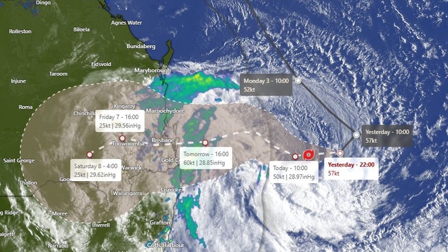
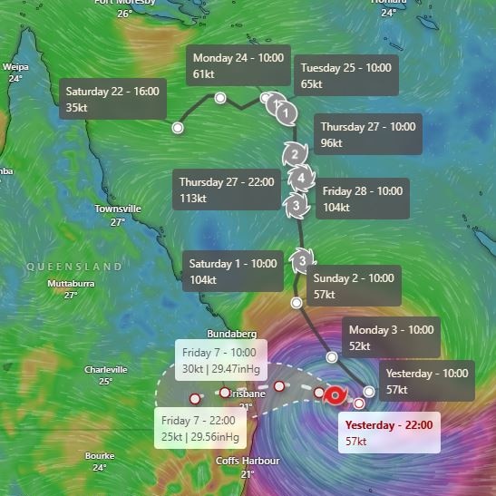
The system, located 425km east of Brisbane on Wednesday morning, has slowed to a crawl, moving at just 11km/h. A typical tropical cyclone travels at about 15 to 20km/h.
Late Tuesday, the cyclone was expected to make landfall around 2am Friday, but now it is not expected to cross until 7am.
Experts are concerned the slower Alfred moves towards Queensland, the more intense it will be once it makes landfall.
Currently expected to cross as a category 2, the Bureau of Meteorology has not ruled out it intensifying to a category 3.
Thomas Hinterdorfer from Higgins Storm Chasing said the slow movement of the system mattered for a lot of reasons.
“Firstly, the system is going to stay over the ocean for longer, so it’s going to have more time to benefit from the fuel that it’s got. It’s going to have more time in the lower vertical shear. It’s going to have more time with the warm ocean waters, and all that fuel is gonna help it intensify,” Mr Hinterdorfer said.
He went on to say when it impacts the south east, it would be that “little bit stronger”, and when moving over land the slow movement could mean that the system could hang around longer.
“That heavy rain, those … damaging, destructive winds, they’re going to last potentially for 12 to 14 hours for some areas. So this entire slow movement just means that we get hit for longer, it has longer to get stronger,” Mr Hinterdorfer said.
“It’s not a good scenario to have it, you know, being a bit slower, we’d much prefer it to come through faster.”
The typical tropical cyclone usually travels at about 15 to 20km/h according to Mr Hinterdorfer, with the steering mechanisms for Alfred – the ridges and upper troughs – competing and resulting in less forward momentum.
With landfall now likely to be at about 7am on Friday morning, Mr Hinterdorfer said there is a “real possibility” the system could be upgraded to a category three, but would likely not remain that way for long as it makes landfall.
“There is some model data there going for winds in excess of category three strength,” he said.
“Now it’s only just entered that better environment last night, we’ve already seen the category two wind field expand quite a bit in that time, but it’s just gonna be a matter now of more, will it have enough time to get there?”
“If it was to make category three strength, it’ll only be in a short distance from the coast.
“So does the land interaction as well start to play a role in nullifying that intensification?

There are some question marks, obviously, about this, but it’s certainly a possibility,” Mr Hinterdorfer said.
Bureau of Meteorology senior meteorologist Dean Narramore stressed that while Tropical Cyclone Alfred was likely slowing down, there would still be damaging wind and rain.
“No matter when it crosses if it speeds up or slows down, we are still going to see huge amounts of rainfall, we are still going to see destructive winds,” he said.
“There will be no impact on the wind or rain whatsoever, they are still exactly the same and they are going to be pretty bad.
“Even if it did weaken into a one or strengthened into a three which was unlikely, if that did happen the impact would not change, to be honest.
“It is still going to be very windy, it is still going to have massive rainfall leading into flooding. We are still going to have storm surges.”

Monster weather system brings storm, heavy rain to Qld
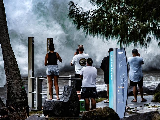
Brisbane and surrounding parts of the southeast have been hit by storms and heavy rainfall this afternoon as a 3000km-long monster low moves across the state.

Wild storms, polar blast as 3000km monster low barrels towards Qld
The system, which stretches 3000km from north to south and encompasses 30 per cent of Australia, is forecast to pack a punch when it hits Queensland.