
‘Dangerous’ weather system to hit Queensland coast tonight
A “dangerous” weather event is headed for the Queensland coastline where rain totals of up to 1m pose a risk of flooding with an update detailing where can expect flooding.
QLD weather news
Don't miss out on the headlines from QLD weather news. Followed categories will be added to My News.
A flood watch has been issued for parts of north Queensland as a trough nears the coastline where rain totals of up to a metre are expected.
The Bureau of Meteorology on Wednesday afternoon issued the early advice of possible flooding for coastal catchments north of Rollingstone to the Daintree.
The catchments are generally dry after a mild wet season in the state’s north but the bureau has advised localised minor flooding is still possible and disruption to transport routes are likely within the flood watch area.
It’s been a dryer-than-average wet season for parts of north Queensland but that could change from Wednesday night due to a trough in the Coral Sea.
Catchments likely to be affected include:
Daintree River
Mossman River
Barron River
Mulgrave and Russell Rivers
Johnstone River
Tully River
Murray River
Herbert River
Helen Kirkup, from the Bureau of Meteorology, said the system was expected to deepen and move towards the coast throughout Wednesday.
“Those two things mean that we expect to start seeing rainfall overnight tonight from that Townsville coastline up through to Cooktown,” Ms Kirkup said.
“The real movement of this trough means the Cassowary Coast and Cairns area are going to start being impacted overnight tonight and tomorrow and continuing into Friday.
“After that it depends on where that trough moves but the general gist is a lot of the region could see daily rainfall of 50mm to 150mm.”
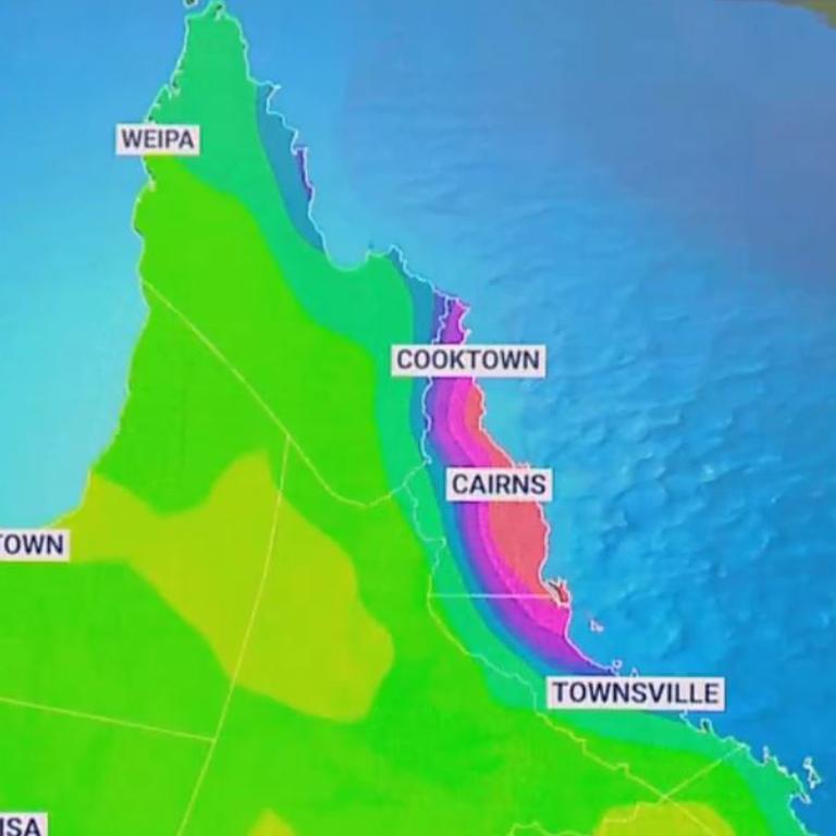
Ms Kirkup said the Cassowary Coast often copped the brunt of similar weather systems and the area could see daily totals of up to 300mm.
She said the five-day weather event could dump totals of 1m on some towns.
The huge totals bring the risk of flash flooding.
“What happened last year is we got one of these systems sit there for a few days and we got moderate flooding around the Tully area and the Mulgrave-Russell ended up in floods,” Ms Kirkup said.
“So it’s not out of the question but we don’t have warnings out because its not yet really clear what actually is going to evolve in that regard
“Our message to people is really that over the next few days it could become a bit dangerous up there so just be careful if you’re out and about.”
Ms Kirkup said the a dryer start to the year gave hope that catchments around North Queensland wouldn’t be impacted as badly as they were when a weather system moved over the region in April 2021.
Rain and shower activity has already kicked off in some parts of North Queensland with 116mm falling on the Lockhart River in the Gulf region.
Rain is also on the way for the state’s south after a southerly change at Coffs Harbour on Wednesday morning.
Ms Kirkup said the weather “shouldn’t be anything like” what residents in the north are bracing for.
The southerly change is expected to impact the Gold Coast by Thursday to be met by a second trough coming from the west.
It’s expected showers will consistently push onshore from Friday but they shouldn’t be carrying huge amounts of rain.
Ms Kirkup said parts of the southeast could receive 5mm to 10mm on Friday with some areas missing out altogether.


Storm shield: How AI will protect our state of disaster
Queensland has secured world-first AI storm detection technology in a $3m partnership between Suncorp and the state government to revolutionise natural disaster response.

Hail, rain, wind, SNOW: Winter storm on Qld collision course
A rare winter storm threatens to dump 15cm of snow on Queensland's Granite Belt this weekend as forecasters warn of an incoming polar air mass.