
Cyclone Jasper: Crews ready, panic buying as storm approaches
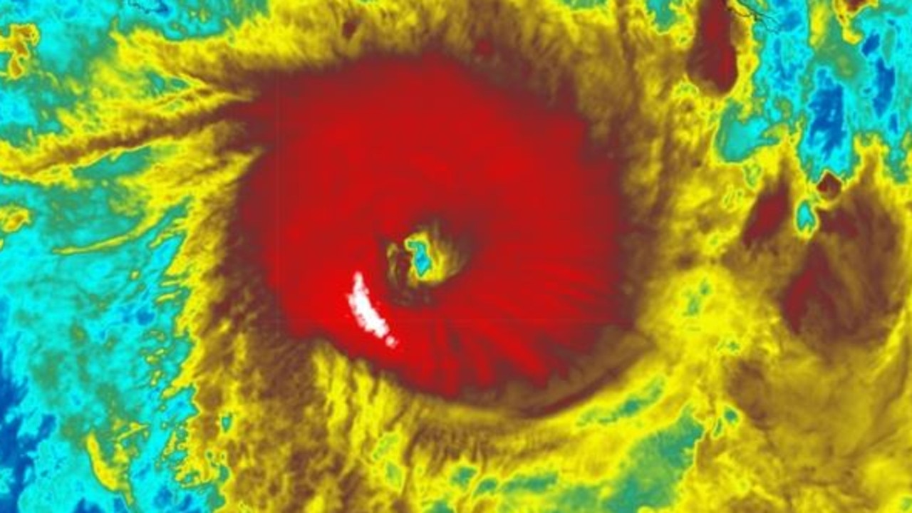
Tropical Cyclone Jasper has weakened to a category one overnight, but its impact is already being felt along the coast, and it could still hit Queensland as a category three system.
QLD weather news
Don't miss out on the headlines from QLD weather news. Followed categories will be added to My News.
Tropical Cyclone Jasper could be a zombie weather event that hits the Queensland coast as a category three system, before weakening overland and then spinning back into a cyclone as it moves over The Gulf of Carpentaria.
The Bureau of Meteorology has warned damaging winds and heavy rainfall are expected along the North Queensland coast from Monday before the cyclone makes landfall, possibly as a Category three system as early as Wednesday.
Jasper weakened to a category one system overnight, with the Bureau of Meteorology expecting the system to now re-intensify to a category two cyclone by Wednesday when it makes landfall.
The Bureau’s Helen Reid said Jasper’s expected landfall was most likely between Cape Flattery and Cardwell.
“We are still expecting a lot of rainfall and flooding, the category is more related to the strength of winds,” she said.
“Jasper is moving quite slowly at 20km/h westwards, which is partly why it has weakened.”
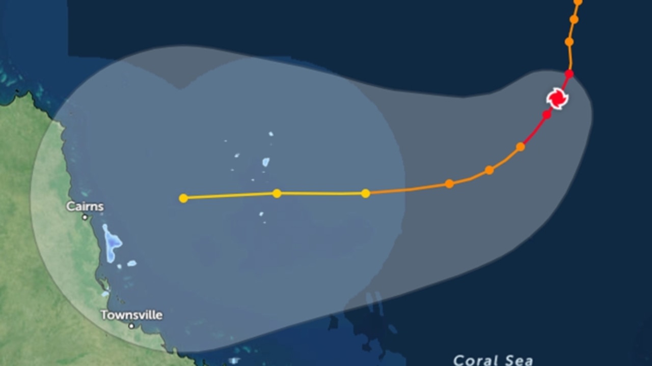
As of 4:50am the system was offshore towards the southeast of Willis Island and 600km east of Cairns.
Parts of the Queensland coastline, specifically on the reef, have begun to experience strong winds.
A flood watch warning of possible “river level rises, including widespread minor to major riverine flooding” is current for the North Tropical Coast, parts of the Cape York Peninsula and Gulf Country.
It also warns that localised flooding, including flash flooding is likely, due to widespread rainfall in the flood watch area.
Ms Reid said over the past 24 hours some spots were receiving gusts of 45km/h to 50km/h including Cape Flattery and Low Isles just off Port Douglas and Cairns.
“Willis Island recorded about 38 knots [70km/h] which is currently northwest of the centre, so it is quite windy through there,” she said.
Parts of Flinders Reef recorded 62km/h winds and Marion Reef, which sits between Townsville and Mackay, recorded 52km/h gales.
“Even Hamilton Island has picked up 30 knots [55km/h] so there is quite a broad area being exposed to those higher winds, really anything out in the reef you’re looking at gale force already,” Ms Reid said.

Ms Reid added that for Jasper to re-intensify into a category three system by landfall on Wednesday, the system would need more time.
“To fuel a tropical cyclone it would need a fresh energy source from a new sea surface environment, a change of wind through the depth of the atmosphere to spin it up a bit more rather than let it fall apart,” she said.
“We would have to see the very fine balance of movement, for it to be slow enough to re-intensify but not too slow for it to weaken.”
The Bureau have said Jasper is being watched around the clock, and with the right conditions, could still re-intensify up to a category three cyclone come landfall on Wednesday.
Ms Reid added residents in these areas should keep watch of the current warnings and ensure their cyclone preparations were in place.
The Bureau on Sunday night issued an alert for damaging winds averaging 60 to 70km/h gusting to 90km/h were likely for offshore islands and exposed coastline between Mackay and Bowen from Monday morning.
BOM meteorologist Jonathan How said winds would first increase along the southern flank of the system.
“So we have issued a severe weather warning for damaging winds that currently covers communities north of Mackay and up towards Bowen, including Hamilton Island for damaging winds of up 90km/h increasing through Monday,” Mr How said on Sunday afternoon.
“But as with all tropical cyclones we’re also expecting to see dangerous storm surge as well as heavy rainfall.
Mr How said rainfall maps showed some areas receiving in excess of 200mm depending where and when the cyclone made landfall.
“But by Friday, it is expected to weaken back into a tropical low but from there into next weekend could push out over The Gulf of Carpentaria and redevelop into a tropical cyclone,” he said.
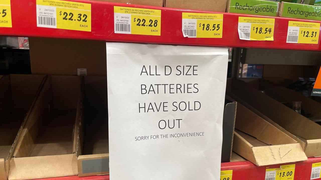
North Queensland communities in the firing line spent the weekend preparing for severe weather, with supermarket shelves in some areas stripped bare of essentials including bottled water and batteries.
Moments before announcing her shock retirement from politics at a press conference on Sunday, Premier Annastacia Palaszczuk said “all preparations are well and truly in place” for the natural disaster.
“It is expected to make landfall between Cape Melville and Cardwell most likely during Wednesday,” she said.
“And if I just can remind Queenslanders particularly in North Queensland to take care, if it’s flooded forget it.”
Moments before announcing her shock retirement from politics at a press conference on Sunday, Premier Annastacia Palaszczuk said “all preparations are well and truly in place”.
“It is expected to make landfall between Cape Melville and Cardwell most likely during Wednesday,” she said.

“And if I just can remind Queenslanders particularly in North Queensland to take care, if it’s flooded forget it.”
The system was downgraded to a Category 2 storm overnight, with winds near the centre of about 100km/h and wind gusts to 140km/h but is expected to strengthen.
Senior BOM meteorologist Jonathan How said as Jasper moves towards the coast, it was expected to increase into a category three system.
“We are quite confident now of that area of crossing, and with landfall we are expecting damaging and destructive winds, heavy rainfall, flooding and quite dangerous coastal conditions as well.”
Gales may also develop near the coast between Townsville and Cape Melville from Tuesday before impact on Wednesday when the core of the tropical cyclone reaches the coast.
Mr How warned residents to expect gale force winds to ramp up along the north tropical coast of Queensland.
“We are expecting to issue the first cyclone watch today for gale force winds in the next 48 hours,” he said on Sunday.
“We could also see some damaging winds further south along the coast near Townsville, so we will be issuing some warnings down there,” he said.
Mr How said the Bureau was urging residents to keep up-to-date with their warnings and advice from QFES, especially with the amount of tourists holidaying in these areas.
He also added there could be large rainfall totals right along the coast with a high chance of severe flooding.
“Certainly the highest rainfall will depend on where the cyclone moves and once we have a good idea of exact rainfall that is where the heaviest falls will be.
“We’re expecting rain to exceed more than 200mm as it crosses the coast, with much higher isolated falls depending on the movement.”
EARLIER
The Bureau of Meteorology has warned that no matter where Cyclone Jasper crosses the Queensland coast it will be a “significant weather event” bringing destructive winds, flooding rains and treacherous seas.
Late on Saturday afternoon, the Bureau said the cyclone had weakened to a category 3 system.

“It’s still severe but its wind speed is down to about 120km/h, with gusts of up to 165km/h,” senior meteorologist Shane Kennedy said.
“The cyclone is now just over 1000 kilometres off Cairns due east. It is still forecast to continue weakening to a category 2 by Monday morning.
“More regular updates will come out when we have a Cyclone Watch and updates will be put out every three hours or hourly depending on the closeness,” he said.
Earlier today, meteorologist Angus Hines said Jasper’s probable path was becoming clearer and that regardless of where it crossed it would be a “significant weather system … likely to bring damaging to destructive winds, heavy, persistent rain that will lead to flooding, storm surges along the coast and very dangerous conditions out over the water, with large waves.”
It comes as swift-water rescue crews and emergency personnel remain on standby while authorities fear a wave of panic buying in the north of the state.
Updated forecasts on Saturday show Jasper inching closer to Cape Melville and Townsville, with landfall expected by Wednesday.
The seven-day tracker shows Jasper likely to cross the coast late on Tuesday and into Wednesday before continuing across the far northern interior of the state, according to the Bureau of Meteorology.
Jasper is forecast to weaken to a category 2 system over the next few days, but it may intensify before crossing the coast.
Mr Kennedy also addressed the broader weather impacts across the state as Jasper approaches.
“Winds will start to increase over coastal waters from Sunday, with strong warnings forecast north of Rockhampton starting from Sunday and continuing for much of next week. Wind warnings will likely increase to gale warnings or higher closer to the tropical cyclone next week.”
He also predicted an increase in rain for most of North Queensland.
“Showers will increase over northern Queensland from Monday, mostly between Cooktown and Mackay, as the tropical cyclone approaches. Daily rainfall of 5 to 20mm is possible on Monday and Tuesday, with isolated falls of 50mm or more,” he said.
“Showers will tend to steady rain mid next week as the tropical cyclone crosses the coast, with daily rainfall between Cooktown and Townsville of 50 to 200+ mm possible on Wednesday and Thursday, depending on the position and strength of the system. A Flood Watch is likely to be issued for northeastern catchments on Monday or Tuesday in anticipation of this rainfall.”
“Rainfall will ease from Friday if the system tracks west across Cape York Peninsula as forecast.”
“The remainder of the state will largely stay dry for the next few days, apart from the chance of a thunderstorm over Western Cape York Peninsula. A new trough system will bring showers and thunderstorms to the southwest on Wednesday, this will slowly move east over the following few days.”
Townsville Local Disaster Management Group deputy chairman Kurt Rehbein said they were well-prepared if Jasper headed for the city.
The bureau predicted heavy showers would develop along the coast of Queensland from Monday, and said it would closely monitor any possible flooding for coastal catchments in North Queensland.

In 2019, Townsville endured a one-in-100-year flooding event which caused widespread damage across the city.
In 2011, Cyclone Yasi also caused damage to the city and surrounding regions.
Mr Rehbein said they were ready for whatever came their way – cyclone or potential flooding.
“I get the feeling the community are pragmatic about this weather event,” he said.
“They know where it is, they’re getting ready. It gives us, as a city, time to finalise our preparation over the weekend.
”We just have to wait and watch to see what happens.”
Townsville residents had already started to strip shelves of bottled water and toilet paper as Jasper moved slowly towards the coast.
The last severe and destructive tropical cyclone to cross the Queensland coast was Cyclone Debbie in 2017, when it struck the Whitsundays as a category 4 cyclone.
Since then, an influx of new residents have moved to the Sunshine State, including to North Queensland, from southern states.
Mr Rehbein urged people to remain calm, and for locals with cyclone experience to share their knowledge with those new to the North.
“Chat to your neighbours and pass on advice,” he said. “You don’t want to be caught out if the skies turn grey.”

In response to the looming threat, Cairns Mayor Terry James has advised the community to take necessary precautions.
“Council is continuing to monitor Tropical Cyclone Jasper and determine how to best protect infrastructure as, and if, required,” Mr James said.
“As a cyclone approaches, residents should take these precautions to protect themselves and their family and home, and broader community.”
Mayor James advised residents to secure or remove any outdoor items that could be hazardous in strong winds, such as outdoor furniture, children’s play equipment, tools, kerbside rubbish bins, and barbecues.
He also urged residents to tie down sheds and other small structures, secure caravans, boats, and vehicles, and prepare their backyards by removing debris, trimming trees and branches, and cleaning out gutters.
“People should also ensure they have household emergency kits and a household emergency plan,” Mr James added.
Residents in coastal, low-lying, or flood-prone areas can access free sandbags from Cairns Council’s waste transfer stations for severe weather preparation.
“Residents are required to fill the sandbags with sand on site; scoops for filling are supplied,” Mr James stated.
Queensland Police Deputy Commissioner Shane Chelepy said residents north of Mackay needed to prepare their emergency kits.
“From Mackay, all the way through to Cairns, I have personally engaged with disaster co-ordinators and preparation is well under way in those areas,” he said.
“We know that if we have a cyclone cross, the first 72 hours is critical for emergency services to be able to get our response mechanisms in place.”
He urged those in the cyclone’s predicted path to keep their car topped up with fuel, have enough food for three days, a charged power bank and a stock of bottled water.
Queensland Fire and Emergency Services Deputy Commissioner Kevin Walsh said crews were making plans and checking equipment to ensure they were ready for the cyclone. Swift water rescue crews were also getting ready to deploy, if needed.

“When we get a little bit more certainty as to where this cyclone may cross, we will be deploying additional resources into those areas …” he said.
Acting Superintendent of Technical Response Darren Welsh emphasised QFES’s readiness for the potential impact of Jasper, ensuring that all necessary supplies were at hand for the regions that might be hit.
“All our career firefighters, our swift water rescue technicians, we’ve got over 430 of them statewide. So they are positioned in each region,” he said.
“SES are … putting their volunteers in position and getting them resourced where they need to be, same as Queensland ambulance and police local governments.
“They’re all preparing … for the worst-case scenario.”

Join the conversation

Why is it so cold? What about these winds? Your Qld weather questions answered
Multiple flights have been cancelled and temperatures have plummeted – so what does it all mean for Qld?
Read more

Strong winds, freezing temps as ‘cyclone bomb’ delivers parting shot
Wild winds have continued to smash South East Queensland, as icy blasts from the “cyclone bomb” hitting NSW and forcing the cancellation of multiple flights deliver more knock-on effects in the Sunshine State.
Read more