
Bureau warns 300mm could fall within six hours as southeast braces for worst on Thursday and Friday
A second deluge tipped for Thursday afternoon has failed to materialise, but the southeast is still under threat overnight and into Friday.
QLD weather news
Don't miss out on the headlines from QLD weather news. Followed categories will be added to My News.
South East Queensland is braced for a second rain bomb overnight as an expected Thursday afternoon deluge failed to materialise.
The Bureau of Meteorology issued new alerts at 5pm on Thursday, saying the southeast could be impacted by intense rainfall and damaging winds.
Rainfall totals up to 300mm are also forecast to impact areas on the coast and north of Brisbane.
Locally intense rainfall may impact areas tonight and into tomorrow, and could potentially lead to flash flooding.
Rainfall totals of 80 to 120mm, but possibly as much as 180mm, are forecast to impact a band from east of Gympie to Jimboomba southwest of Brisbane over a six-hour period.
Residents could expect the heaviest of this rain to fall late Thursday night and into Friday morning.
Parts of the Sunshine Coast could also experience wind gusts up to 90km/h, while Brisbane, the Gold Coast and surrounding areas were also in line for heavy rain.
A severe thunderstorm warning for the Capricornia district was cancelled by the Bureau of Meteorology on Thursday night.
At 6.37pm, the Bureau provided an update on their severe thunderstorm warning for people in Darling Downs and Granite Belt, and parts of Central Highlands and Coalfields, Wide Bay and Burnett, and Maranoa and Warrego forecast districts.
The heavy rainfall in inland Queensland may lead to flash flooding in some areas over the next several hours, with the bureau suggesting that Dalby, Roma, St George, Goondiwindi, Mungindi and Tara may be impacted.
Myall Park Road Alert had 73.4mm in two hours up until 6.30pm today, while Lundavra had 51mm in the hour before 5.50pm.
Residents in the Darling Downs and Granite Belt, parts of the Central Highlands and Coalfields, Capricornia, Wide Bay and Burnett, and Maranoa and Warrego districts were also expected to be impacted by heavy rainfall.
A severe thunderstorm warning for the central west has been cancelled.
The second wave of the deluge was expected to hits the southeast on Thursday afternoon but, despite scattered showers throughout the day, by late afternoon the trough was still lingering offshore.
Saturating storms on Wednesday claimed the life of 63-year-old Philippa Tayler after her car became stuck in floodwaters in the Sunshine Coast hinterland.
And the body of a missing motorcyclist was found on Thursday morning after a full-scale air, water and land search at Cedar Pocket in the Gympie region.
The man was believed to be local husband and father of three Phil Lambert.
The 54-year-old left work at 1am yesterday and it is believed he was swept away by floodwaters half an hour later.
The man’s body was located around 11.30am on Thursday, when divers were able to access an area that had been previously too dangerous to search near where the motorcycle was located.
Investigations are ongoing and police will prepare a report for the coroner.
Severe Weather Update: torrential rain continues for south-east Qld and north-east NSW. Video current: 12.30pm AEST 24 February 2022
— Bureau of Meteorology, Australia (@BOM_au) February 24, 2022
Know your weather, know your risk. For the latest forecasts and warnings, go to our website https://t.co/TsXvtqWZoM or the #BOMWeather app. pic.twitter.com/ucMqBKJwbY
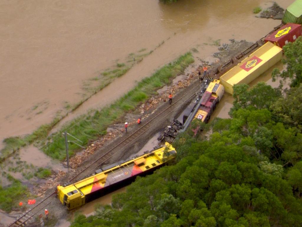
Schools were closed, roads were flooded and a train became derailed after more than 300mm fell in some parts of the region on Wednesday.
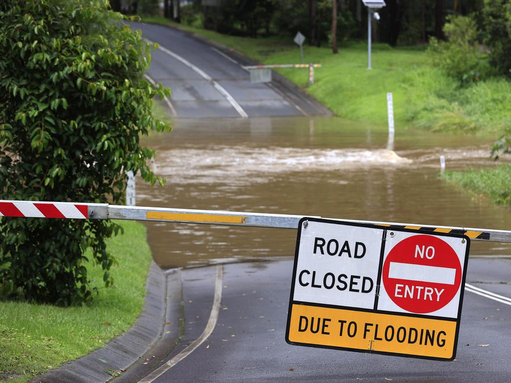
Police have called on people living in southern Queensland to rethink their need to travel and to avoid flooded roads.
“If it’s flooded: forget it and just back up,” they said.
Police have also reminded parents to ensure children are not playing in flood-prone waterways, watercourses and drains.
The rain event is predicted to last until Saturday lunchtime, with 72-hour rainfall totals expected to exceed 300mm across the board.
“This is quite a significant and dynamic event which can change quickly so we ask for people to stay on the ball and be diligent in keeping an eye on the weather warnings on our website,” bureau atmospheric scientist Brooke Pagel said.
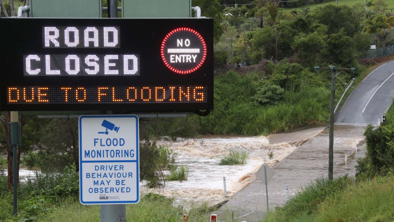
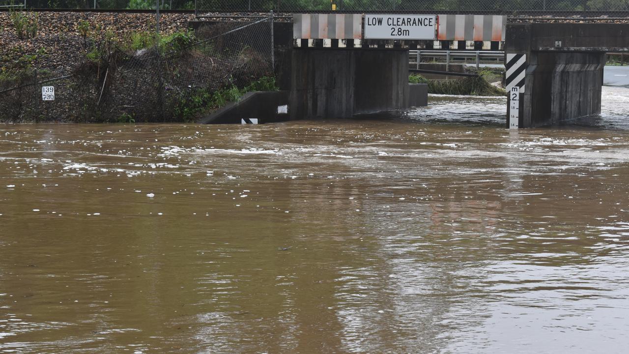
The bureau warned at 12.55pm that widespread flooding would likely affect 16 South East Queensland river catchments.
“Catchments are wet, and likely to respond quickly to further rainfall,” the bureau said.
Flood warnings remain for the Mary and Stanley rivers, and the Sunshine Coast.
Catchments to be affected by heavy rainfall included
Baffle Creek, Kolan River, Burnett River, Burrum and Cherwell Rivers, Mary River, Noosa River, Sunshine Coast rivers and creeks, Pine and Caboolture rivers, Upper Brisbane River, Lower Brisbane River, Logan and Albert rivers, Gold Coast rivers and creeks, Condamine Rivers (Upper Condamine River), Macintyre River, Weir River and Moonie River.
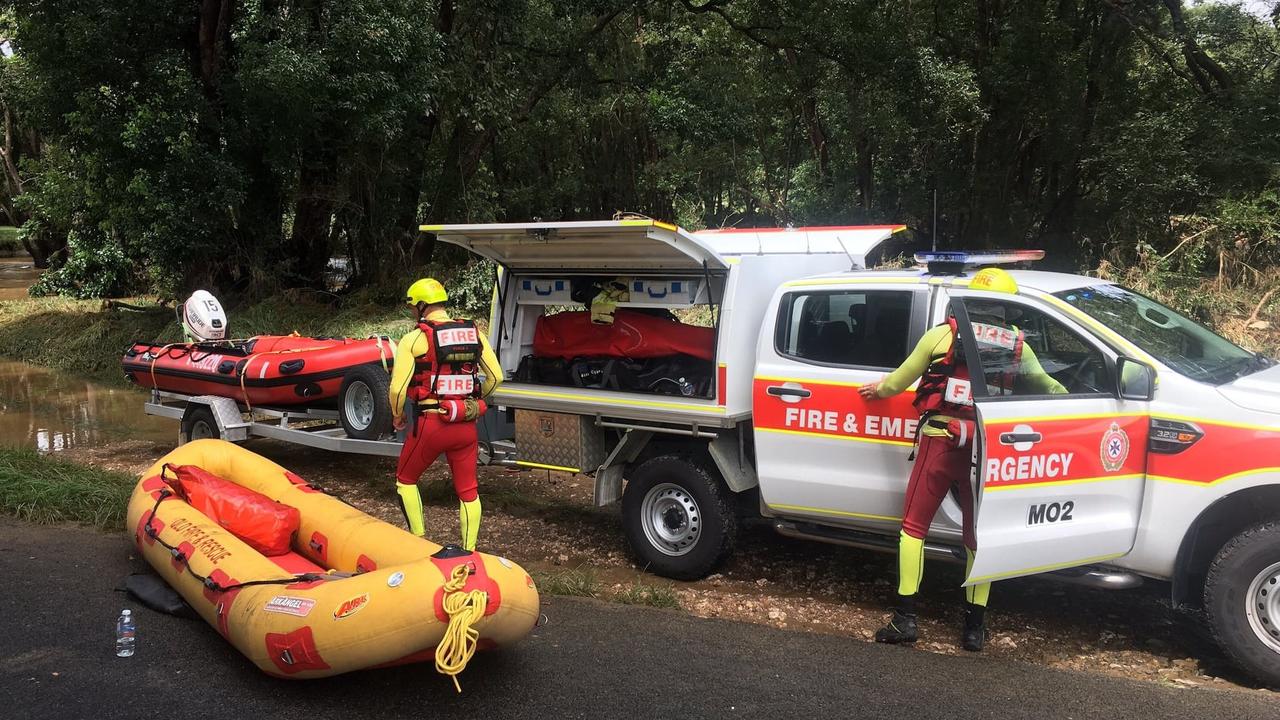
Emergency services conducted more than 240 storm related tasks over the past 24 hours, including 19 swift water rescues, mostly on the Sunshine Coast.
Three people were rescued from a house in Goomboorian, another from a shed in Belli Park and one from a rural property at Glenview.
Multiple drivers were retrieved from their cars at Doonan and a member of the public jumped into action in Pomona to rescue someone from a submerged vehicle.
Police say there are no other suspected missing persons related to the flood event, despite earlier reports that 10 people were unaccounted for.
Overnight, rainfall totals were a long way down on those from the night before, with the highest figures appearing on the Gold Coast and near Caboolture.
Numinbah received 65mm in the 20 hours from 9am, Binna Burra 62mm and Worongary 60mm, while Caboolture recorded 56mm.
In the northern parts of the Sunshine Coast, which bore the brunt of the worst conditions on Tuesday night with totals above 400mm in places, totals of 10mm-11mm were recorded in the 20 hours to 5am.
Meteorologist Felem Hanniffy on Wednesday said the focus of the most intense conditions on Thursday and Friday would likely be around the Sunshine Coast and Brisbane.
“We could see falls broadly of 100mm to 200mm with localised totals well in excess of that again on Thursday,” he said.
“The risk will be in the morning and again later in the day so we might see a bit of a reprieve during the day time.”
Mr Hanniffy said there was less of a risk of intense rainfall on the Gold Coast. However, there is the possibility of damaging wind gusts of more than 90km/h over the southeast coast.
The wild weather is coming from a slow-moving trough, which is to remain over the South East on Thursday.
The Bureau has warned the risk of flash flooding would extend inland Thursday over areas between Double Island Point, Kingaroy, Oakey and Stanthorpe.
Six-hourly rainfall totals between 80mm and 120mm are likely, reaching up to 180mm over areas east of Gympie and Ipswich with falls of up to 300mm also possible.
“Locally intense rainfall leading to dangerous and life-threatening flash flooding is possible during this period with six-hourly rainfall totals up to 300mm,” the weather warning stated.
It comes after falls of 200-300mm on Tuesday night, including 308mm at Pomona, 183mm at Landsborough, 158mm at Sippy Downs and 170mm at Pelican Waters.
Police confirmed a 63-year-old woman died in floodwaters at Belli Park, near Kenilworth, about 8am.
Her body was found in a submerged car.
Sunshine Coast Police District Superintendent Craig Hawkins on Wednesday said it was too early in the investigation to determine exactly what had happened to the woman.
“It’s terrible not only for her family and friends, but also difficult for emergency services when we are pushing this message constantly, yet we still see people driving into flood waters,” Superintendent Hawkins said.
“We didn’t expect this amount of rain. So if it’s flooded forget it.
“That’s where we start seeing people put themselves in risky situations and where we see loss of life.”
On Wednesday morning, Superintendent Hawkins said authorities were searching for up to 10 people who were unaccounted for after the widespread flooding event. By the early afternoon, all persons were located aside from a man whose motorbike was found in floodwaters at Greens Creek, near Gympie.
“We are still searching for that man who we have grave concerns for,” Superintendent Hawkins said.
“He left home for work and never arrived.
“His motorcycle was located in flood water at Greens Creek, near Gympie, but our search is still under way to try to locate him.”
Animals have also fallen victim to the floodwaters with farmers reporting that livestock and pets missing across the region.
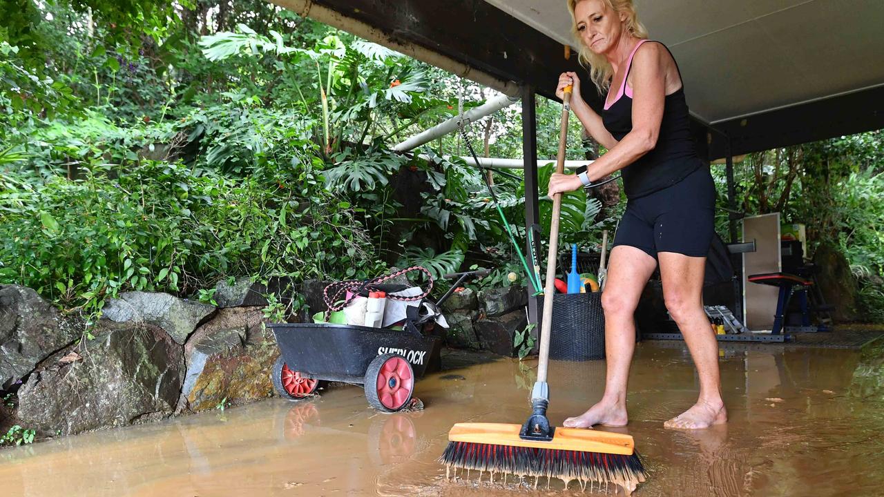
Danielle Pope, from Federal, said she was grateful her horses, dogs and cats were safe after water gushed into her property just before midnight on Tuesday.
Ms Pope said her home smelled badly on Wednesday as every room of her house was saturated.
“I couldn’t stop the water despite using every blanket, towel and sheet,” she said.
“It got to a point where I had nothing left and I fell asleep from exhaustion with water lapping around my bed,” she said.
Ms Pope’s family remained at their property on Wednesday night with her husband and son digging trenches around the house as they braced for more rain.
Kenilworth dairy farmer Shane Paulger said the storm was unlike anything he had seen in his 60 years living on the Mary River.
He said the river rose at an incredible speed and by about midday on Wednesday it was close to breaking the banks.
“I went down to look early this morning and it had about three quarters of a metre at 2am, and by 4.30am it had gone up seven metres,” Mr Paulger said.
“The speed of it was quite surprising. Crikey it rose quick. It might have matched the big floods of 1989, for the speed in which it rose.”
Mr Paulger said the storm came in about 8pm and stayed a constant threat the entirety. Queensland Rail suspended passenger train services between Caboolture and Gympie North due to flooding over the tracks while a third-party freight train has derailed between Traveston and Cooran stations about 3.20am.
It’s understood the train derailed carrying general freight with one driver on board who was believed to have escaped with only minor injuries.
A Queensland Fire and Emergency Services spokeswoman said two crews were called to the scene after the train derailed due to floodwater on the train line.
BOM has issued a flood watch and various flood warnings are current for parts of South East Queensland.
Locations that may be affected Thursday include Warwick, Gold Coast, Toowoomba, Brisbane, Maroochydore, Gympie, Stanthorpe, Caboolture, Ipswich, Jimboomba, Mount Tamborine and Redcliffe.

Join the conversation

Feels like -5.3C: Icy blast sends temps plummeting again
South East Queensland has again shivered through a freezing start to the day, as a brutal cold front continues to blast the region with subzero temperatures, made worse by chilling winds.
Read more

Feels like MINUS 7.1C: Brutal cold front blasts southern Qld
A brutal cold front is blasting across southern Queensland with subzero temperatures and widespread frost.
Read more