
Brisbane weather: Conditions to ease after another day of rain
The Tweed has dodged a flooding disaster, with water levels starting to recede in the northern NSW community after evacuation orders were earlier issued. It comes as southeast Queensland and northern NSW clean up after a severe weather event.
QLD weather news
Don't miss out on the headlines from QLD weather news. Followed categories will be added to My News.
The Tweed has dodged a flooding disaster, with water levels starting to recede in the northern NSW community.
Evacuation orders had earlier been issued for several Tweed villages but by early Tuesday afternoon water levels at low-lying areas traditionally hammered by foods were receding.
PHOTOS: SOUTHEAST SMASHED BY WILD WEATHER
Residents in Chinderah, Tumbulgum, Condong and parts of Murwillumbah had been anxiously waiting for the collision between high tides and roaring creeks emptying into the Tweed River, but flooding was only relatively minor.
The Gold Coast also escaped the worst of the erosion damage, with some minor beach erosion while some low-lying areas saw water over the road at the peak of the high tide.
There has been little rain in the region today, with tonight’s high tide not expected to bring fresh threats.
It comes after more than 200mm fell in the Gold Coast hinterland in the 24 hours to 9am today.
The Bureau of Meteorology says 214mm of ran fell at Upper Springbrook since 9am yesterday, taking the weekly tally to a whopping 967mm in the area.
BOM Meteorologist Peter Markworth said it was a “huge” amount of rain that fell on Upper Springbrook.
“Almost a metre of rainfall in a week is a huge amount,” he said.
He said while there was less rainfall expected today, tides were set to remain high.
“There’s still a severe weather warning for abnormally high tides, half a metre above the highest astronomical tide stretching from the Fraser Coast down to the Gold Coast.”
“There’s still some decent coastal showers at the moment around the Sunshine Coast and the Gold Coast as well, so we’re not completely out of the woods with this event just yet.”
“We have a chance of seeing showers and thunderstorms inland of the southeast coast today bringing potentially heavy falls and isolated thunderstorms this afternoon in Toowoomba and the Darling Downs.”
Meanwhile, the clean-up and recovery from the past few days of weather continues.
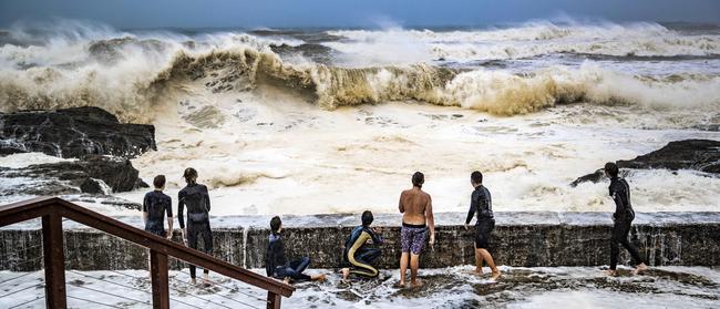
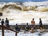
Entire beaches were left covered with foam, while others were completely washed away as massive swells, squalling storms and frenetic winds battered the coast between the Fraser Coast and northern NSW.
Parts of the southeast have recorded over 800mm of rain since Saturday morning, while the force of winds, which exceeded 60km/h at times, caused mayhem in Surfers Paradise yesterday, with panes of glass blown from a high-rise to shatter on the streets below.
The tempest also shattered the holiday plans of Victorians, whose first taste of Queensland after a nine-month travel ban left them soaked and disappointed.
For George Apex and his mates, the long-awaited Queensland holiday turned into a drenching, while their home city of Melbourne basks in a rare stretch of perfect summer weather.
The group booked a week on the Gold Coast as soon as the borders reopened on December 1 and arrived on Saturday, straight into the belly of a beast that has lashed the Queensland coast for three days.
“We didn’t even think about the weather,” Ibby Vayne said.
“We just assumed it would be nice. Come on, it’s the Gold Coast – it’s always nice up here.”
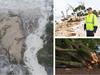
A man was rushed to hospital after his car reportedly lost control on a wet road and crashed into a tree at Greenbank southwest of Brisbane.
Emergency services were called to reports a car had aquaplaned and crashed into a tree on Spring Mountain Drive about 6pm, a Queensland Ambulance Spokesman said.
A man in his 30s was taken to the Princess Alexandra Hospital under lights and sirens with serious chest injuries.
Milder showers and potential storms are expected to linger in the southeast until at least tomorrow.
The northern section of Bribie Island has been eroded due to usually high tides and large waves associated with the weather system.
“This section of Bribie Island has a long history of erosion and it is part of the natural process for the area, however, this is the first time this section of the island has had waves break through the dune,” Queensland Parks and Wildlife Service said in a statement.
As the weather system moves south, northern NSW is expected to cop more rain, destructive winds, damaging surf and an offshore king tide of up to 10m today.
Yesterday, 8200 people were without power, and more than 250 insurance claims had been lodged with the RACQ as a consequence of the bad weather.
The SES have received 1368 emergency calls for help since Saturday 6pm.
“We are expecting more claims from this weather event which may include some tidal/salt water claims.” RACQ spokeswoman Lucinda Ross said.
The Bureau of Meteorology had issued a flood watch for coastal locations south of Hervey Bay as a vicious cocktail of hazardous surf, abnormally high tides and heavy rainfall caused sea levels to surge.
“Sea levels about the southeast Queensland coast are expected to exceed highest astronomical tide … with large sea level anomalies due to the spring tides and the expected winds,” Bureau of Meteorology forecaster Laura Boekel said yesterday.
Streets and cycleways were flooded in inner-city Brisbane, while photos from Sandgate showed waters reaching as high as car wheel arches.
Announcing the closure of northern parts of Bribie Island to the public, QPWS warned the weather could create environmental hazards, including steep sand dunes, deep washouts and gutters, hidden banks, fallen trees, exposed coffee rock and large debris on exposed beaches.
“Out in the oceans where we’re seeing the hazardous surf and the high tides, that is what we would see with a low-pressure (system) or a tropical cyclone moving towards the coast,” Ms Boekel said.
In the Gold Coast hinterland, a serious landslide yesterday afternoon saw 3m rocks block Tamborine Mountain Rd.
Little Nerang Dam was spilling after rising by more than 35 per cent in the past seven days. Wappa Dam and Lake Macdonald are also spilling, after a triple-digit deluge on the Sunshine Coast.
Meanwhile, in drought-ravaged Stanthorpe, the past two weeks have brought more rain than in the previous three months.
The heaviest falls were recorded in Upper Springbrook, where 807mm of rain was recorded since Saturday morning.
“In 24 hours over the weekend, they saw 475mm … and the following day within 24 hours they saw another 200mm as well,” Ms Boekel said.

Qld battens down for overnight blast in bomb cyclone ripple effect
Wild winds of up to 100km/h were set to slam South East Queensland overnight as icy blasts from the “cyclone bomb” that battered NSW also hit the Sunshine State.

7 questions we’re all asking now about Qld’s crazy weather
Multiple flights have been cancelled and temperatures have plummeted – so what does it all mean for Qld?