
Brisbane weather: Coldest day in 22 years as Queensland gripped by intense cold snap
Brisbane has shivered through its coldest day in more than two decades while five Queensland communities have experienced their coldest day on record as an extreme cold snap intensifies.
QLD weather news
Don't miss out on the headlines from QLD weather news. Followed categories will be added to My News.
Brisbane has shivered through its coldest day in more than two decades while five communities have broken records as an extreme cold snap intensifies across eastern Queensland.
The city recorded a maximum temperature of 12.4C about 1pm on Tuesday, the coldest in 22 years. Brisbane’s coldest-ever maximum was 12C in July 2000.
The city’s third-coldest July maximum came just 24 hours earlier, with Monday’s top of 14.2C the seventh-coldest day on record.
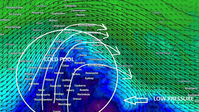
Across most parts of Queensland, temperatures have been eight to 12 degrees below average.
Five Queensland areas broke records for coldest day ever recorded by the Bureau of Meteorology, including two which smashed a 35-year-old record.
Biloela, Mackay and Cardwell broke records made only 24 hours earlier on Monday, with Cardwell facing the most dramatic temperature drop of 0.6 degrees.
Meanwhile Mareeba and South Johnstone both broke previous annual records dating back to 2014 and 1968 and Low Isles broke its record for coldest July day.
Meteorologist Helen Reid said it was another “noteworthy” record breaking day.
“It is unusual that it is back to back days that are that cold. There are places that would have had a colder temperature on Monday compared to yesterday, so to have two consecutive days is noteworthy,” she said.
“Another one for the books.”
And more bitterly cold conditions could be on the way, with amateur forecasters predicting temperatures to plummet on Thursday next week.
Brisbane Weather Facebook group says it could feel like 1C in Brisbane that day, while the Granite Belt down of Stanthorpe could get to -9C.
Ms Reid said thick cloud cover had shifted over the Tasman Sea, with the state expected to see some sunshine as early as Wednesday afternoon.
“The cloud band is shifting away, it’s now moving over the Tasman but that miserable drizzly rain will probably see out the course of today,” Ms Reid said.
“You may see some sunshine towards the end of the day, depending on the sunset.
“Once this cloud is gone, it’s looking sunny on Thursday and Friday and on the weekend it’ll be a mix of cloudy and sunny conditions with a chance of a shower along the coast.”
Brisbane temperatures have finally started to warm after staying at a consistent 12C for almost 24 hours.
Ms Reid said the pestering rain and thick cloud cover had kept conditions cool in the capital city, which recorded a chilly 12C from 6am Tuesday through to 5am Wednesday, before increasing slightly to 13C about 6am this morning.
“The rain is what’s evening out the temperatures between night and day. The sun’s coming up but it’s been stopped by the cloud cover and the blanketing off the cloud then means it won’t cool down at night,” Ms Reid said.
“But yesterday’s minimum temperature in Brisbane was colder than what we are experiencing thus far today.
“We’re on the rise.”
Temperatures are forecast to start heating up from today as cloud cover shifts even further south with Brisbane and the Gold Coast expected to hit a maximum temperature of 21C, the Sunshine Coast 20C and Ipswich 22C.
But warmer temperatures have come with a warning, with Ms Reid saying clearer skies would lead to a drop in overnight temperatures.
“Overnight temperatures will drop down a bit because overnight skies will be clearer, maybe 9C, 10C but particularly inland where there’s less wind compared to the coast, those areas could drop down to 4C and 5C by the weekend.”
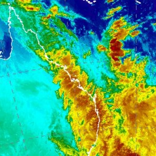
That has also seen a number of rainfall records broken, with Cairns and Mareeba experiencing their wettest July days on Monday.
On Tuesday, 12.8mm of rain fell in Brisbane, with the largest falls again near Cairns where 100mm has fallen since 9am yesterday.
A total of 114mm has been recorded at Mackay since 9am Tuesday, 109mm at Bowen and 54mm just north of Rockhampton.
It comes after many cold weather records were broken across the state on Monday, with Townsville, Mackay, Rockhampton, Gympie and the Sunshine Coast all recording their coldest July days on record.
Temperature records broken on July 5
Biloela 11.4C / 11.8C on June 4, 2022
Mackay 13.2C / 13.4C on June 4, 2022
Cardwell 16.0C / 16.6 C on June 4, 2022
South Johnstone 16.2C / 16.4C on August 17, 1968
Mareeba 18.1C / 18.4C on June 15, 2014
July temperature records
Low Isles lighthouse 20.5C / 21.1C on July 24, 1968

Ice ice baby: Spectacular images of unseasonal frost as Qld freezes
Queensland’s overnight temperatures will increase to double digits in the coming days, following the coldest start to winter in 16 years, bringing frost and ice to many regions. SEE THE PHOTOS

City’s coldest June start in 16 years, feels like MINUS 9.8C out west
Southeast Queensland is shivering through its coldest morning in more than 15 years but feels-like temperatures have dropped to insane levels in the southern inland.