
Brisbane weather: 60+km/h winter winds set to hit southeast Queensland before spring relief
Southeast Queensland residents are being urged to stay indoors due to a dust haze leading to very poor air quality, as the “Ekka winds” continue to blow in to Brisbane.
QLD weather news
Don't miss out on the headlines from QLD weather news. Followed categories will be added to My News.
A health warning has been issued for southeast Queensland as a dust haze leads to “very poor” air quality in parts of Brisbane and the Gold Coast.
The Bureau of Meteorology says a haze was caused by dust being picked up “in the interior in windy conditions yesterday” and being blown in across the city today.
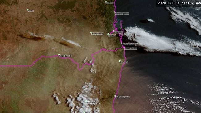
The Department of Environment and Science has issued a ‘very poor’ air quality warning for parts of Brisbane and is urging people to stay indoors, particularly “sensitive” groups, including those with asthma and other lung diseases, people with heart disease, people with Type 2 diabetes, those aged over 65, infants and children and pregnant women.
Meanwhile, the winds of winter are set to smash southeast Queensland one last time over the coming days, with gusts upwards of 60km/h predicted.
While Wednesday’s unique summer swelter pleased a lot of Queenslanders craving warmer temperatures again, the Bureau of Meteorology says it’s going to get a lot worse before it gets better.
Very high fire danger for southeast Qld as winds and temperatures soar
Duranbah bushfire: Water bombers deployed as fire burns across 160ha
Yesterday, parts of the state including Brisbane, Toowoomba and the Sunshine Coast copped 50km+ winds, with Gatton getting smashed with 60km/h gusts. This was combined with warmer temperatures throughout the region, with the Sunshine Coast and Brisbane hitting 30C at parts of the day.
Those strong winds are set to continue today, with BOM Meteorologist Salem Hannissy predicting the gusts will stay around, and peak at 60-70km/h winds again on Saturday.
“We’re going to be in for a few gusty days around the southeast, though it’s not all going to be as strong as Wednesday” Mr Hannissy said.
“Saturday is the big day for it though, with 60-70km/h predicted for the coastal regions, including the Sunshine Coast, Brisbane and Gold Coast. You’ll even feel them as far in as Toowoomba.”
Hazy conditions in #Brisbane today! Take extra care on the roads and drive to conditions. pic.twitter.com/ELoH5PkUuW
— RACQ (@RACQOfficial) August 20, 2020
Though while these may seem like major gusts for parts of the state, Mr Hannissy assured this is normal for the end of winter, with many knowing them as the “Ekka Winds”, being brought on by the swap to warmer spring temperatures.
“This is coming in from a strong ridge and a low pressure system coming in from the inland, though it’s nothing out of the ordinary for this time of year.” He added.
This winds have also sparked up very high fire danger forecasts for the state as well, with a bushfire already burning south of the QLD border as a result of strong winds.
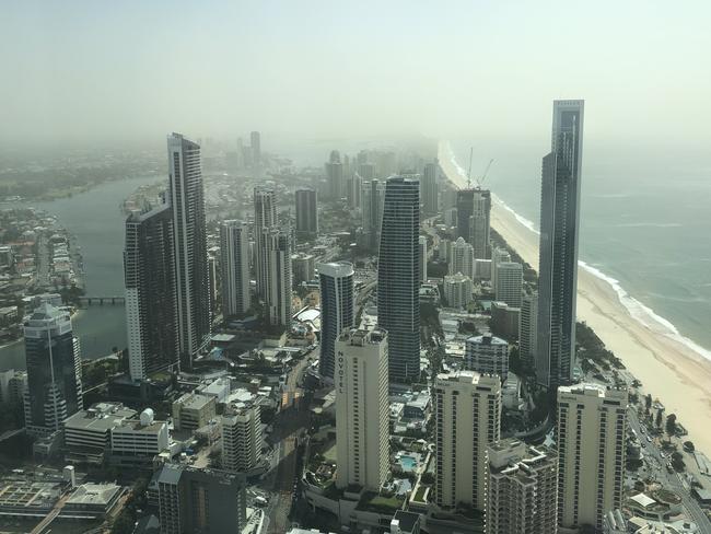
It's looking very dusty and hazy outside in #Brisbane today, stay inside if you have lung/breathing problems! Probably from all the intense cold wind we've been getting. pic.twitter.com/3bFWP7r55o
— Sheree Louise (@ShereeLouiseD) August 19, 2020
Today's forecast has been updated with stronger winds than initially forecast across southern #Queensland. Very High fire dangers now also expected for Maranoa & Warrego, Darling Downs & Granite Belt, Wide Bay & Burnett districts. pic.twitter.com/aWJEmMPGRo
— Bureau of Meteorology, Queensland (@BOM_Qld) August 18, 2020