
ADF troops activated as 350mm new year deluge, flash floods smash SEQ
Australian troops have been activated to help clean up efforts across South East Queensland as the region is drenched by 300mm of rain, and up to 350mm more predicted today. LATEST WEATHER UPDATES
QLD weather news
Don't miss out on the headlines from QLD weather news. Followed categories will be added to My News.
Australian troops have been activated to help clean up efforts across southeast Queensland as the region is drenched by more than 300mm of heavy rain in the past 24 hours, with up to another 350mm predicted today.
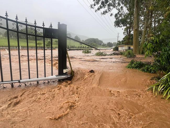
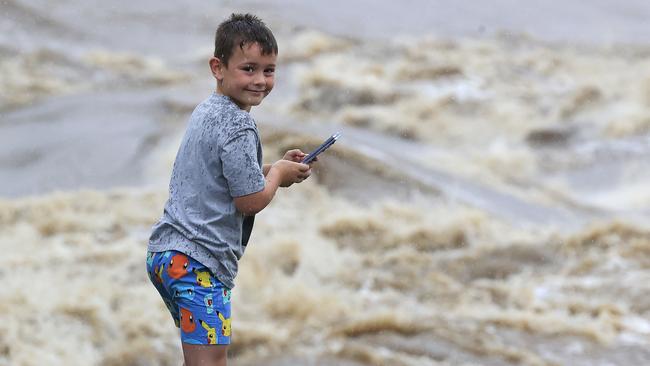
The slow-moving rain cell which had hovered over the Gold Coast and Scenic Rim before beginning to track further north toward the Sunshine Coast has caused widespread flooding, with roads and bridges underwater, parks and backyard inundated and some evacuations ordered.
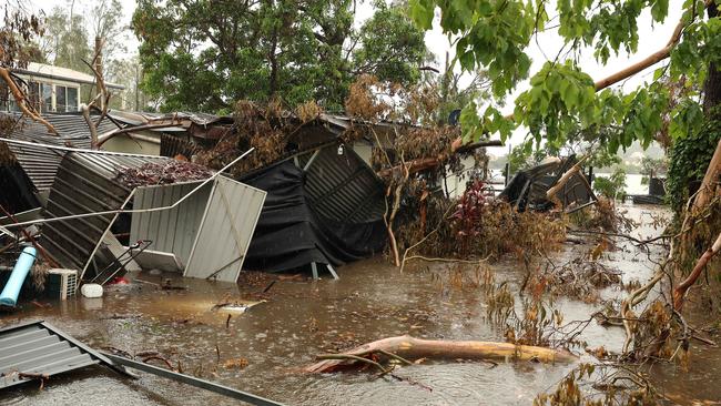
It comes on top of chaos caused by the Christmas night tornado which ripped through parts of the Gold Coast, destroying homes and cutting power to 100,000+ residents.
Since Christmas Day, up to 580mm of rain has fallen in the region.
Federal emergency management Minister Murray Watt confirmed up to 50 Australian Defence Force personnel had been activated to assist, with boots on the ground from January 4 armed with “high-clearance vehicles”.
Their main job will be working at heights to remove debris and ensure roofs are made safe, including for the restoration of electricity.
“So we’re literally in the process right now of getting them mobilised,” he said.
“Initially. We expect them to be available for a week. There’s an opportunity to extend that period if necessary.
“But having seen ADF personnel in action in the past, I know they’ll be able to get through a lot in that period of time.”
Senator Watt said the deployment of troops had been a matter of discussion each day as the complexities of responding to the disaster are worked through, with the minister acknowledging federal MPs across the aisle for also flagging the need for the military.
There are 70 volunteers from Disaster Relief Australia, an organisation powered by veterans, on the ground assisting with disaster recovery.
A total of 88 SES Victorian and 42 SES New South Wales volunteers have been flown up to Queensland to help, with 170 of the state’s own SES crews on deck.
Dozens of campers at a popular national park had to be evacuated amid heavy rain and rising creek levels.
QFES Assistant Commissioner Stephen Smith said 44 out of 60 campers at Natural Bridge campground were evacuated on New Year’s Day and taken to safety after water levels rose rapidly and unexpectedly.
The rest of the campers opted to stay put.
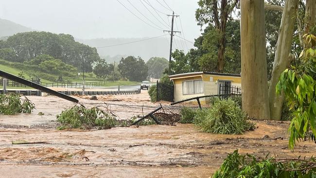
Acting Premier Cameron Dick confirmed 11,000 homes and businesses remained without power, with certain parts of the grid requiring a total rebuild after being “shredded” in storms.
“Some of the parts of the power system have been obliterated effectively and they have to be rebuilt,” he said.
“You’re seeing some of the power lines that have effectively been shredded by the wind that impacted that part of Queensland.”
There are about 700 Energex crew members out in the field to restore power, with SES crews called in from Victoria and New South Wales to assist.
Mr Dick said after a request from the community on Sunday, the state government had been in further discussions with the federal government about bringing in the Army’s portable generators.
But it has been determined the generators are not suitable for the Queensland electricity grid.
“We couldn’t make it work, but we are looking at other resources including commercial generators as required,” Mr Dick said.
“But Energex has done an amazing job. We’ve got 92 per cent of households and customers… now back online.”
Energex hopes to have the final 11,000 homes reconnected to power by January 5 but that could be delayed by ongoing bad weather.
Seqwater has confirmed it is now monitoring dams in the region, with some spilling excess water and others requiring releases.
Severe weather warnings for the Gold Coast, Brisbane and Sunshine Coast areas and stretching as far up to the Wide Bay and Burnett region were cancelled by 5pm Tuesday.
It comes after huge rainfalls in the South East.
Between 9am and 5pm Tuesday Subarbag Rd at Caloundra received 79mm, nearby Meridan Way had 75mm while Tewantin saw 72mm, and both Mountain Creek and Sippy Downs had 71mm.
In the 24 hours to Tuesday, Cedar Creek, near Ormeau, received 307mm of rain, while Carbrook got 264mm in the same time frame.
North Tamborine received 261mm, while 252mm fell at Mount Tamborine and Beenleigh got 246mm.
Since Christmas 580mm of rain has drenched Springbrook, 439mm at North Tamborine, 324mm at Beenleigh, 293mm at Pacific Pines, 233mm at Carrara, 242mm at Slacks Creek, 223mm at North Stradbroke Island, 216mm at Bribie Island, 162mm at Eight Mile Plains and 120mm at Brisbane Airport.
The threat of catastrophic creek and river overflows like what was experienced in the 2022 southeast Queensland floods is “fairly low” for the next few days but the Bureau of Meteorology has warned the storm season has only just begun.
Opposition Leader David Crisafulli said Gold Coasters affected by the double weather event were in desperate need of cash flow, with damage comparable to Cyclone Yasi.
“Just in Paradise Point, my butcher’s lost north of $10,000 of stock, my bakery over $20,000, the Food Works is over $50,000 and all of them are just sitting there wondering how they’re going to keep staff and keep the doors open,” he said.
“There is real pain.
“I went through Yasi in North Queensland and I can tell you, this is right up there.”
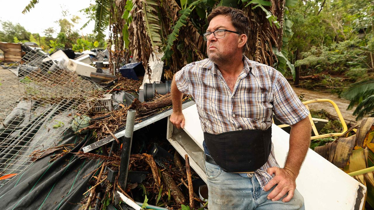
Upper Coomera resident and owner of the Spectrum Nursery Wesley Trevor was hit by the Christmas Day tornado and then flooded on New Year’s Day.
“Ten inches deeper than we’ve ever seen before,” he said.
Mr Trevor has been operating the plant nursery for 28 years, but said the damage was so severe he “couldn’t see a way out of the situation.”
He may have to lay off some of his 15 staff following a minimum $500,000 loss.
“They (staff) are going to be devastated, they’re going to be in tears, they’re going to be upset,” he said.
“It’s really hard on everybody… it’s tough.”
Mr Trevor said it would take years to financially recover, even if structural damage is fixed or rebuilt within 12 months.
At least four feet of water inundated the nursery within a matter of minutes, forcing Mr Trevor to flee the property in his car.
He said it was the worst two storms he’d ever seen, and they happened within the same week.
“We’ve had no power for over a week, we’ve had no internet connection.
“It’s so bad… there’s trees everywhere, we’re driving on the footpath because we can’t get down the street, powerlines everywhere, it’s a nightmare.
“It’s like a war zone. I’ve never seen anything like it in my life.”
Mr Trevor said the Gold Coast City Council needed to reconsider rules around tree lopping.
Mr Crusafulli said today wasn’t the time to scrutinise the government’s disaster response but it was on his agenda for the near future.
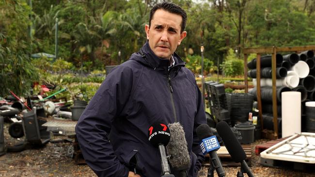
Meteorologist David Grant confirmed there was the potential for some isolated minor to moderate flooding in the Brisbane River in the next 24 to 36 hours amid ongoing heavy rainfall.
The possibility of creek systems reaching levels of February 2022 remained “fairly low”.
“But we’ve still got the 24 hours to play out in this weather event,” he said.
“Going forward, we’re only in early January and our catchments are now truly saturated across the southeast corner.
“We just have to be mindful that if it doesn’t happen during the course of this event, that should we have any follow up rainfall after this one our catchments will be much more responsive than what they may have been at the start of this event.”
Disaster Recovery Minister Nikki Boyd confirmed there had been 700 requests for SES assistance in the last 24 hours, with the total number of calls for help escalating to 4800 since Christmas Day.
A majority— or 3900 calls—were in the Gold Coast area.
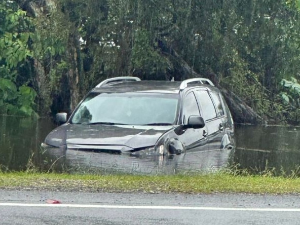
A total of 20 swift water rescues were carried out in the 24 hours to 9am on January 2.
“It’s a very dangerous forecast that we’re facing over the next 24 hours and for many people who are in or around those waterways, we’re asking them to be particularly cautious,” Ms Boyd said.
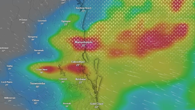
Bureau metrologist Daniel Hayes said in the past 24 hours, major cities and much of South East Queensland have been drowned by heavy and locally intense rainfall.
“Since 9am on Monday the focus of the rainfall has definitely been around the Gold Coast and Gold Coast hinterlands region,” Mr Hayes said.
“Around Brisbane, falls have been less but definitely still severe with most of the metro area sitting around that 50 to 88mm in the 24-hour time span.
“Today, there is that possibility that we could see isolated rainfall of up to 350mm and that categorises as localised intense rainfall that can lead to dangerous and life threatening flash flooding.”
There have been some big falls further up the coast as well, with Maroochydore receiving 130mm of rain, Caloundra 109mm, Mountain Creek 129mm and Nambour 71mm.
“Quite a bit falling there at the moment on the radar and the severe weather warning has us expecting to see heavy rainfall which may lead to flash flooding all across the Sunshine Coast,” Mr Hayes said.
“We’re seeing localised rainfall leading to dangerous and life threatening flash flooding from a cell coming up from the Gold Coast.
“If we’re seeing particularly intense rainfalls then it’s likely we will see separate severe thunderstorm warnings later in the day
“We have a flood watch out for the Sunshine Coast rivers. If it keeps raining we’ll see quick river and creek rises too.”
Alongside Sunshine Coast rivers, flood watches are current for the Upper and Lower Brisbane River, Logan and Albert Rivers, Gold Coast Rivers and Creeks, Mary River and the Noosa River, with BOM warning that even a minor rainfall total could lead to flash flooding and rapid rises.
In an updated weather warning about 10.30am, the Bureau warned Maroochydore, Caboolture, Moreton Island, Noosa Heads, Rainbow Beach and Redcliffe could be affected by flooding.
“We are expecting to see a shift of this weather system, moving north towards the Sunshine Coast and into the Southern Parts of the Wide Bay region,” Mr Hayes.
“Even though the system appears to be moving away from the Gold Coast region which saw a lot of yesterday’s activity, even with a small rainfall total it could lead to a big impact down that way.
“Residents need to look out for not just flash flooding but potential landslides and debris on the road, so staying across emergency service updates is vital.
“It has definitely been a soggy start to the New Year, and we will be across these patterns for the rest of the week.”
Seqwater has officially moved to the ‘Alert’ activation level following intense rainfall throughout much of the region which is only expected to increase.
Cedar Pocket Dam, Wappa Dam, Wyaralong Dam, Little Nerang Dam, Nindooninbah and Leslie Harrison Dam (all ungated dams) are spilling excess waters with emergency services warning residents downstream of the dams to stay away from fast flowing or deep water.
Wivenhoe Dam is sitting at 70 per cent capacity but releases are not expected at this stage.
In a statement, a Seqwater spokesperson confirmed they will be monitoring all dams around the region closely during the next 24 hours.
“Forecast rainfall associated with the current weather system indicates that releases may be required from North Pine Dam, as well as from Somerset (into Wivenhoe Dam), within the next 24-48 hours, in addition to increased monitoring of un-gated dams spilling,” they said.
“This will be dependent on rainfall received, with the situation to continue to be monitored by a Seqwater Flood Operations Engineer.”
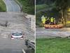
Overnight, emergency services rescues as group of 44 campers after becoming stranded on a private camping ground near Hayters Rd at Natural Bridge, about 50km south of the Gold Coast.
Five people were also rescues when their vehicles became stuck in floodwaters.
BOM, QFES and QPS are urging residents in severe weather warning affected areas to stay across rainfall updates as the day progresses.
Flash flooding is now hitting the Sunshine Coast with water across multiple roads and road damage to another.
Crosby Hill Road at Tanawhat and Old Marchoochydore Road at the Eudlo Creek Bridge, Forest Glen are currently under water along with Niell Road at Mooloolah Valley, Mayers Road at Towen Mountain, School Road at Coolum, Catalina Drive at Mudjimba (the entry from Mudjimba Beach Road), Bottom of Lindsay Rd at Buderim, Palmwoods Bridge, Chevallum Road at Palmwoods, and Stevens Road at Glenview.
There’s been damage to Black Mountain Road from the weather also.
Sunshine Coast Council and the Department of Transport and Main Roads has closed the roads and asked drivers to avoid these are


Ice ice baby: Spectacular images of unseasonal frost as Qld freezes
Queensland’s overnight temperatures will increase to double digits in the coming days, following the coldest start to winter in 16 years, bringing frost and ice to many regions. SEE THE PHOTOS
Read more

City’s coldest June start in 16 years, feels like MINUS 9.8C out west
Southeast Queensland is shivering through its coldest morning in more than 15 years but feels-like temperatures have dropped to insane levels in the southern inland.
Read more