
‘Unusual’ weather pattern could dump heavy rain on parts of Queensland
Heavy rain is on the way for huge parts of Queensland this evening, potentially bringing a much-needed soaking to areas that missed out on the recent wild weather.
QLD News
Don't miss out on the headlines from QLD News. Followed categories will be added to My News.
Queensland residents who have missed out on the rainfall from recent wild weather are hoping there's a decent downpour in storms forecast for this evening.
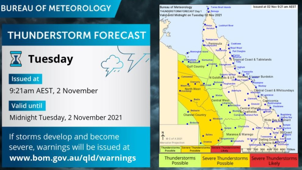
A large part of the state could be in for heavy rain throughout Tuesday afternoon and evening when the Bureau of Meteorology has forecast storms to form across the west of the state.
At 6:38pm, BOM issued a warning that heavy thunderstorms have now extended to the Channel Country.
A warm and unstable air mass across western Queensland is causing severe thunderstorms likely to produce damaging winds and heavy rainfall that may lead to flash flooding over the next several hours.
Locations which may be affected include Cloncurry, Quilpie, Windorah, Eromanga, Selwyn and Mckinlay.
Milroy north of Quilpie recorded 39mm in 30 minutes to 6:30pm.
The possibility of rain was welcome news for the Australian Hotel Motel owner Max Smith who said Boulia was always in the need of rain.
The outback town received a measly 4.6mm of rain when violent thunderstorms repeatedly lashed Queensland last month, and just 7mm in the month prior.
“It’s been overcast for a week and all we’ve received is a few millimetres here and there,” Mr Smith said.
“Some good rain would help fill the water tanks and dams.”
Boulia is in the middle of a large area which meteorologists believe could be impacted by severe thunderstorms which were yet to form at noon.
Severe thunderstorms are possible for the Channel Country at the southern border right up to Gulf Country in the north.
They could bring decent rain for Longreach, which received just 11mm in October, and Mt Isa which received 33.4mm.
“When they do develop they are not looking like they will move very quickly as the upper atmosphere is not very conducive to movement of storms,” BOM meteorologist Helen Reid said.
“So one place could have a thunderstorm go over very slowly and pick up lots of rainfall that way.
“There’s a lot of moisture in the atmosphere through there which is unusual.”
Thunderstorms are possible for about half of the state in the west.
Storms which hit the far north west overnight have drifted across the Northern Territory border.


‘Unlike anything I’ve ever seen’: 2000-strong cast delivers awe-inspiring spectacle
With a cast of thousands guided by some of the best in the entertainment business, the performing arts blockbuster Creative Generation has hit the stage and the show isn’t your typical school performance. Read our review here.

Motorbike rider killed in same region rocked by triple fatal
A motorbike rider has been killed in the same Qld region where three teenagers tragically died in another crash just hours earlier. *Distressing.