
Thunderstorms hit parts of Darling Downs and Lockyer Valley
Parts of the western Darling Downs and South Burnett regions have been hammered by hail, damaging winds and heavy rainfall this afternoon as severe thunderstorms swept across southern and central Queensland. A storm warning remains current for some areas. WATCH THE VIDEO

QLD News
Don't miss out on the headlines from QLD News. Followed categories will be added to My News.
A severe thunderstorm warning has been expanded to include parts of southern and central Queensland this afternoon.
It comes after parts of the western Darling Downs and South Burnett regions were hammered by severe storms earlier.
A hail storm is currently passing through Roma in the south west. Widespread rain totals of 50-100mm are likely across eastern Queensland and New South Wales over the next week. Credit: Jessica Hansen https://t.co/YReZ2enOEh #qldweather #7NEWS pic.twitter.com/xevkMUuv9F
— 7NEWS Sunshine Coast (@7NewsSC) October 22, 2020
Hail and wind gusts to 122kmh were recorded in Roma while video has emerged of drenching rainfall at Murgon in the South Burnett region.
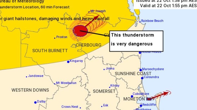
An earlier warning related to a “very dangerous” thunderstorm with the potential for giant hail and flash flooding has since been cancelled.
Severe weather season has started Qld! â›ˆï¸ Would your home be ready if you were hit by a severe storm today? #QldWeather #QldStorm #RACQInsurance https://t.co/t2hEfLYzkx
— RACQ (@RACQOfficial) October 22, 2020
The latest warning, issued at 7pm, states that severe thunderstorms are continuing over parts of the southeast and central areas/
“Severe thunderstorms are likely to produce intense rainfall that may lead to dangerous and life-threatening flash flooding, damaging winds and large hailstones in the warning area over the next several hours. Locations which may be affected include Taroom, Monto, Rolleston and Eidsvold,” the BOM alert says.
An earlier warning for the Maranoa and Warrego districts has been cancelled.
Meanwhile, earlier today the Bureau of Meteorology’s Livio Regano said the most intense storm activity was likely to be inland, with some isolated rain possible in parts of Brisbane.
“We certainly are expecting severe thunderstorms this afternoon but they’ll be mostly inland, it’s not impossible to get a severe one here but it’s unlikely.”
Please make sure items are secured around your home and vehicles are undercover. #QldStorm https://t.co/C2rXUDQNNw
— RACQ (@RACQOfficial) October 22, 2020
“It’s getting really cloudy, there have been some storms really close by, even right now there are some storms going through all the way from pretty close to Maleny in a line all the way down to the city.
He said while thunderstorms were possible, but there was no indication of hail or severe winds.
“They’re quite isolated and fast moving and once they’re through it’s probably more going to be cloudy and drizzly,” he said.
🌩ï¸Severe storms are likely in the #DarlingDowns and Wide Bay & Burnett districts today, & possible elsewhere over inland #SEQld and the Capricornia Coast and highlands. They may produce damaging winds, large hail & heavy rain.
— Bureau of Meteorology, Queensland (@BOM_Qld) October 22, 2020
For any warnings: https://t.co/MYUS15XR5v pic.twitter.com/cbZbqrgVEe
“It looks like we’ve had a few heavy spots just east of the city and in a line extended out to Redcliffe, they are brief heavier falls.”
It is cloudy in Brisbane at a top of 26C, the Gold and Sunshine Coast are also expecting rain.
Higgins Storm Chasing said an intense storm was moving through the Lockyer Valley region.
“Heavy rain, strong winds and hail are all possible with this storm,” they said on Facebook
“Another intense storm / possibly severe storm is located over Jandowae and moving North East towards Kingaroy.
“Isolated heavy storms are popping up along the Gold Coast seaway but these are remaining very hit and miss.”