
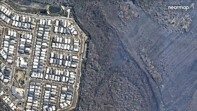
Stark contrast: Before and after Peregian bushfires
Aerial photography has captured before and after images of the Peregian bushfires revealing the full extent of the miracle brought about by firefighters.
Sunshine Coast
Don't miss out on the headlines from Sunshine Coast. Followed categories will be added to My News.
>> Fires force closure of campgrounds over school holidays
THESE images taken by Nearmap in July and again on September 16 reveal the full extent of the miracle performed by rural and urban fire fighters on the late afternoon and evening of September 9.
Only those on the fire front will ever know the detail of each action during that long night that somehow collectively managed to turn away the roaring inferno that was ultimately to destroy one home and badly damage two others.
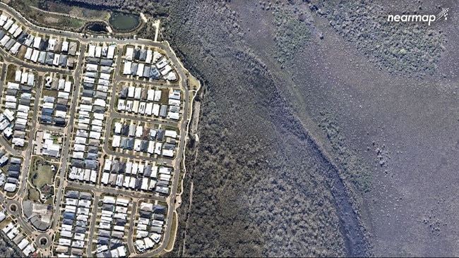
Australian ASX 200 company Nearmap captured these stunning before and after images.
The latest were taken a week ago from a Cessna 210 aircraft at 9am.
Nearmap maintains a searchable, 10-year imagery archive, which allows users to compare an area before and after a disaster and clearly identify the damages.
"The imagery can be used for post-disaster operations such as public safety, tracking the impact of the disaster on utilities, supporting reconstruction efforts, viewing impacted properties for insurance purposes," a Nearmap spokesman said.

The company has high resolution aerial imagery of urban areas covering 89 per cent of Australia's population, 71 per cent of the US population, and 75 per cent of New Zealand's.
They can assist various industries including architecture, construction, engineering, solar, roofing and insurance reducing the need for site visits and even helping businesses like food trucks determine locations of construction sites so they can plan their routes.
Architecture firms can also use 3D imagery to envisage how a new building may look within its proposed environment.
Nearmap uses its own patented camera equipment and processing software to deliver its product to clients, taking high resolution pictures from heights of 8000 to 18,000 feet.
During its 10-year history Nearmap has captured 500 million images and expects to take 500 million photos during the next 12 months.


‘Ultimate breach of trust’: Magistrate to siblings’ alleged killer carer
A carer who allegedly deliberately drove into a tree, killing two sibling clients, claims he’ll be ok if he’s released and can go back to work. *DISTRESSING*.

Senior sparkie’s boozy crash only metres from his home
A seasoned electrician has returned a whopping blood alcohol reading after he was involved in a multi-vehicle crash 20m from his Sunshine Coast unit.