
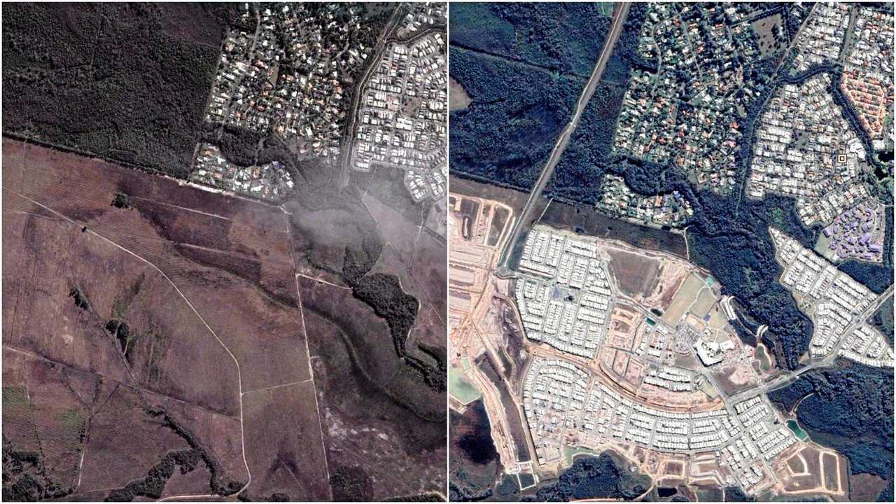
SATELLITE IMAGES: How the Coast has changed over time
BEFORE AND AFTER: As the Coast continues to boom, the landscape of the region is constantly changing. These interactive images show the dramatic changes.
Sunshine Coast
Don't miss out on the headlines from Sunshine Coast. Followed categories will be added to My News.
AS THE Sunshine Coast's population continues to boom, the landscape of the region is constantly changing.
The Daily has looked at how different development hot spots across the Coast have adapted over the past 10 years.
From Stockland's Aura at Caloundra South, AVID's Harmony at Palmview and the major Birtinya boom, historical imagery shows the dramatic changes to the region.
Using Google technology, we've created interactive before and after images so you can see just how fast the Sunshine Coast is growing.
Bruce Highway upgrades
While it's a constant source of frustration for commuters, there have been major developments for the Bruce Highway on the Sunshine Coast.
The Bruce Highway, Caloundra Rd to Sunshine Motorway upgrade has created more than 600 jobs and is expected to be completed by the end of 2020.
Premier Annastacia Palaszczuk says improving the section of the highway will cater for the Coast's continuing growth.
"Some 62,000 vehicles go up and down this highway every day and we need to make sure that we are catering for the growth," she said.
Bruce Highway Sunshine Motorway:
Bruce Highway Caloundra Road:
Sunshine Coast University Hospital and Birtinya
Since the Sunshine Coast University Hospital opened in 2017, the surrounding area has seen huge growth.
From the Stockland Birtinya shopping centre to the Bokarina Beach development, the area has changed dramatically in the past 10 years.
Caloundra South
Stockland's $5 billion Aura development at Caloundra South continues to grow at a swift pace.
With the rapidly growing community welcoming up to 10 families each week, thousands of residents now call Aura home.
Hundreds of new houses have been constructed in Baringa and Aura Central is now open to the public.
Aura Central will be the future heart of Aura and will feature a future 90-hectare City Centre, a People's Place with a South Bank-style parkland, and a range of sporting and education facilities as well as the residential precinct which is currently under construction.
Sippy Downs and Palmview
Like Aura, AVID's Harmony development continues to see huge growth with more people moving to the region.
The $3 billion master-planned community has been overrun with local demand since its launch in 2016.
Harmony is set on 378 hectares and will deliver more than 4800 homes for 12,000 future residents, all enhanced by 100 hectares of open space.
Maroochydore
From the widely-popular Sunshine Cove development, the Sunshine Plaza redevelopment and the new Maroochydore CBD, the area has gone though major changes in the past 10 years.
Historical imagery shows the subtle yet major changes to Maroochydore, and there's no slowing down.
*Note: Google Earth is yet to update its satellite images of the Sunshine Coast this year. The latest images represented in these comparisons are from various times in 2018.
Luxury hotel $900m economy boost in beachside mecca
A freshly approved luxury The Calile Noosa has been welcomed as a shot in the arm for a ‘plateaued’ economy, with one organisation predicting a more than $900m boost in the beachside hotspot.

Father-son duo’s violent botched hinterland car theft
A woman has been viciously attacked after a father and son’s ‘terrifying’ attempted car theft before being caught by brave residents in the Sunshine Coast hinterland.