
Storms, rain to continue with Cyclone UESI beckoning
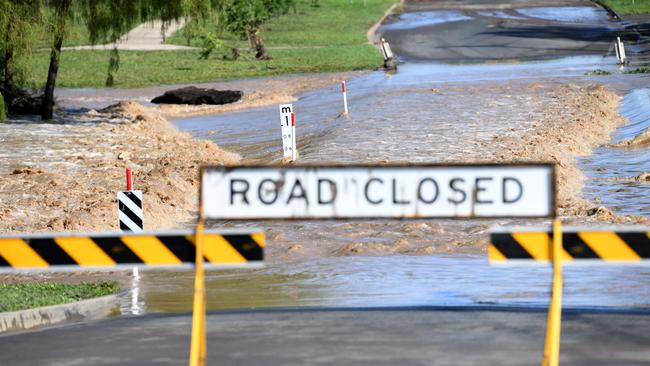
Flood warnings remain as rain and storms continue to hit the Darling Downs and the southeast after emergency services carried out multiple swift-water rescues during a busy night as downpours of more than 100mm in an hour smashed parts of the region.
QLD News
Don't miss out on the headlines from QLD News. Followed categories will be added to My News.
FLOOD warnings remain as rain and storms continue to hit the Darling Downs and southeast Queensland.
A severe storm warning has been issued by the Bureau of Meteorology for Warwick, Toowoomba, Stanthorpe, Oakey, Clifton and Pittsworth.
The warning was issued at 2:31pm with heavy rain and winds expected.
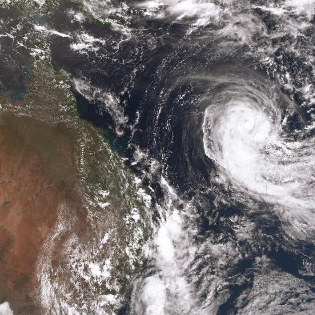
A severe tropical Cyclone is edging towards the southeast and will bring with it strong winds and large swell.
Cyclone UESI will cause anywhere south of Fraser Island to see “some increasing easterly swell,” Ms Wong said.
From Thursday we are expected to see massive waves hit across the southeast coast.
“Possibly peaking around three to three and a half metres waves causing some quite hazardous swell,” Ms Wong said.
The large swell battering the coast is predicted to coincide with a king tide posing a serious erosion threat to the east coast.
Dr Annie Lau, a geography professor at University of Queensland, warns people to stay away from the beach during the dangerous conditions.
“For sure we can expect some erosion across the beaches but there is no unprecedented danger at the moment,” Dr Lau said.
Cyclone UESI will bring some very windy conditions to the coast as it moves closer to the east.
“Cyclones are very hard to predict but as it moves over the cooler water it should slow down.”
Cyclone UESI is currently sitting to the north west of New Caledonia currently but will move closer to Queensland throughout the week.
Rain will continue across the southeast with around 50-100mm and heavy falls possible across the coming days.
Drier weather is expected for the weekend.
Rainfall averages have been broken with Stradbroke Island topping the list with over 450mm so far this month already.
Broken February rain records
Coolangatta – 201mm previously 160mm, 1995
Oakey – 115mm previously 98mm, 1998
Pratten, 111mm previously 80mm 1997mm
Warwick, 105mm previously 58mm, 2008
The biggest overnight falls came in Kilcoy at Gregor’s Creek, west of Caboolture which had a huge 135mm fall overnight.
The heavy storm that hit the area brought 105mm of that total in just one hour caused major flooding of the Upper Brisbane River.
Luckily, the area was quite large and isolated so no one was believed to be injured in the flooding.
The area has now been downgraded to minor flooding but a warning is still in place for the Upper Brisbane River.
The main reason for the recent and ongoing heavy falls is a surface trough (a low pressure system) running through the northwest to the southeast of Queensland.
This trough draws in the moisture from the east coast creating these stormy and rainy conditions that have lashed the state
The current warnings in place are at Upper Brisbane River, lower Flinders River, Georgina River and Eyre Creek, Condamine and Balonne Rivers, Myall Creek, Moonie River, Weir River, Bulloo River, Dawson River, Paroo River, Thomson and Barcoo Rivers and Cooper Creek.
RACQ have received 574 insurance claims for homes and vehicles due to flood and storm damage in the last week alone.
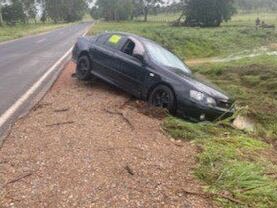
A search for a man and woman feared missing after a vehicle was found abandoned in floodwaters near Nanango is over.
The couple have been found by police.
A QPS spokeswoman said the couple had never been reported missing.
“They are safe,” she said.
Their black Ford Falcon had been broken down after being caught in floodwaters near Stock Yard Creek on the Burnett Highway.
“They’d flagged down someone for a lift,” she said.
Police made contact with both the man and woman this morning.
Police would like to thank the public for their assistance.
It comes after a number of evening storms and heavy rain across the southeast and Darling Downs during which another four people were rescued from flood waters.
Emergency services retrieved a man and woman who were trapped in flash flooding near Morayfield.
The adult man and woman were stranded at the end of Elm Court at around 11:40pm last night.
SWIFT water rescue attended the scene and rescued the pair at around 12:15am.
Paramedics treated the two and they were taken to Caboolture Hospital for precautionary measures.
A man in his late teens was caught in a flooded vehicle in Kurwongbah, Moreton Bay.
He was able to make his own way out of the waters at around 1:16am last night and was uninjured.
Two people were rescued after their car was washed off the road in Yalangur, northwest of Toowoomba.
One of the pair, a 70-year-old man, was taken to Toowoomba Hospital in a stable condition.
Police are urging the public to be cautious around all flooded roads.
“Stay out of them, don’t go into flood waters,” she said.
“If it’s flooded, forget it.

Mum charged with three counts of murder over horror house fire
A mother has been charged with three counts of murder over the death of three young children in a horror house fire in Toowoomba.

Horrific cat video act of man who murdered flatmate with gas bottle
A man who killed his Brisbane flatmate, posed as her online and extracted hundreds of thousands of dollars as the woman’s body was kept in a toolbox for months has been found guilty of murder.