
‘Severe’ fire danger as hot spell here to stay
Summer may have only just begun but the hot weather has already settled in. Temps are expected to stay ‘above average’ in the southeast corner all week, with one town likely to hit 39C by Friday.
QLD News
Don't miss out on the headlines from QLD News. Followed categories will be added to My News.
SOUTHEAST Queensland is bracing for an entire week sweltering in the mid-to-high 30s, with hot conditions and strong winds expected to fuel fire dangers today.
Severe fire dangers are predicted for much of the southeast of the state today, with the Bureau of Meteorology saying maximum temperatures this week will remain well above the seasonal average.
“The average for Brisbane in the city in December is 29.5C,” meteorologist Jess Gardner said.
“We’ll be a fair bit above average.”
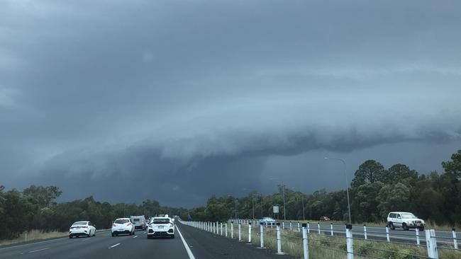
Bushfire threat to worsen as severe storms forecast for southeast
Everything you need to do if your car is damaged by hail
40km/h winds and a top of 34C were forecast for Brisbane today, with maximums not falling below 33C for the rest of the week.
Fire dangers were expected to hit severe in the Capricornia, Central Highlands and Coalfields, Darling Downs and Granite Belt, Wide Bay and Burnett and Southeast Coast regions, according to the Bureau, fuelled by the strong winds and warm conditions.
Forecasts for the week ahead showed no let up either, Ms Gardner said, with Brisbane predicted to swelter through 38C and Ipswich 39C on Friday.
“Not for the next week. Those temperatures are pretty high right through until next weekend,” she said.
The hot conditions followed an upper trough which moved across Queensland yesterday, bringing damaging winds and thunderstorms to the southeast.
Surf Life Saving Queensland was forced to close beaches on the Gold Coast yesterday afternoon as a series of dangerous storms passed through.
Bombshell DV crackdown: Dating app bans, forced to share passwords
Domestic violence offenders could be dealt control orders similar to those used for organised crime and bikies under sweeping changes proposed by the Queensland Police Union.

Secret, big-profit investment hiding in your wardrobe
What can give you up to five times the return on your investment as real estate and as much as 10 per cent more than the ASX, and could be hiding in your wardrobe?