
More rain yet to fall as region turns green
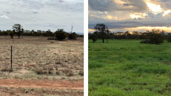
Residents around Central Queensland are celebrating after last month’s downpour, with some areas recording up to 300mm in their areas.

Rockhampton
Don't miss out on the headlines from Rockhampton. Followed categories will be added to My News.
RECENT rainfall has done wonders to the Central Queensland region as various areas of the land spring back to life.
Even residents from as far west as Blackwater are reaping the benefits of last month’s generous downpour.
Blackwater woman Bonita Floyd said the property near her home had enjoyed more than 300mm since the start of the year.
Others from areas including Westwood, Emerald and Rockhampton have shared their delight online with some incredible before and after photos.
In even better news for the region, rainfall looks unlikely to let up over the coming week.
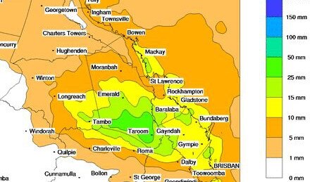
The Bureau of Meteorology forecast that over the next eight days approximately up to 50-100mm could fall for some areas.
Light storms are expected up until Friday, where heavier showers are likely to return and remain over the weekend.
“Wednesday is pretty quiet, though there’s a surface trough just over south western Queensland with most of its activity concentrated just to the east of that,” meteorologist Shane Kennedy said.
“It’s expected to drift east over the next couple of days so that should see an increase in rain activity later in the week.”
Mr Kennedy said Thursday would deliver a medium to high chance of increased falls for Rockhampton, while areas surrounding Emerald and Blackwater would also experience increased rain.
A wet weekend is expected for most of the region, with Saturday expected to deliver heavier rain.
“We’re expecting to see around 10-30mm on Saturday in the area, however there’s a potential for up to 40-70mm as it moves in underneath a thunderstorm,” Mr Kennedy said.
The possibility of flash flooding is a risk, Mr Kennedy said, thanks to the heavier rainfall and damaging winds have also been forecast over the period.
Unfortunately, warm and humid nights are expected to remain over upcoming days before a cooler change sets in throughout the weekend.
“It’s sitting a couple of degrees above average, around 3-5 degrees above both inland and on the coast,” Mr Kennedy said.
“When that trough moves through, we’ll see bit of a wind change to the south west by Saturday.
“That should help bring some reduced temps, but only by 1-2 degrees.”
Do you have a before and after photo of your property to share? Send them to kaitlyn.smith@capnews.com.au.

Miner’s alleged chop-shop car used in 17 heists
A former miner is accused of chopping up two stolen vehicles, piecing them into one and using that rebirthed car to carry out more than 17 break-ins at various businesses.

Central Qld cowboy defies injury to star on debut in Origin opener
Teenager Thomas Triplett has helped lead the Maroons to victory in the PBR State of Origin series opener, earning big wraps from team coach Jared Borghero.