
Mount Morgan to Gracemere rail trail: Council looks to build recreational path along the Razorback
A rail trail proposed near Rockhampton would start at the Mount Morgan Railway Station and end at Cedric Archer Park, covering 29km. See videos and a full break-down of the route.
A rail trail for walkers, cyclists and potentially horse riders along the rugged former Mount Morgan to Gracemere rail corridor could become a reality in the next few years.
A feasibility study was recently completed on the project and came back with a green light for council to go ahead with the proposal.
The study looked at the benefits, costs, constraints and opportunities of the recreational rail trail on the disused Mount Morgan to Kabra railway line.

The railway corridor is owned by the Department of Transport and Main Roads (TMR) and would be leased to Rockhampton Regional Council.
Council received $250,000 (100 per cent funding) from the TMR Rail Trail Local Government Grants Program for a feasibility study which was awarded to SEQ firm Burchills Engineering Solution in early 2021.
The rail trail would begin at the existing Mount Morgan Railway Station and would finish at Cedric Archer Park, covering about 29km.

The construction of the rail trail was estimated to cost $13.1 million with a maintenance cost of $148,350 per year.
It was estimated the project would create 24 direct local jobs, 37 indirect jobs and inject $11.2 million into the regional economy.
Community consultation on the project closed in September and was held in two rounds with 113 submissions received in the first round and 66 in the second round.
For the first round, 87 per cent were in support of establishing the multi-use trail.
A preliminary design was created and was released in the second round of consultation and 51 people of the 66 were in support of the project.
The supportive responders were not adjoining landholders and nine people were specifically opposed to the proposal.

Many of the responders used the interactive mapping online to suggest stops and locations for shelters, horse drinking troughs and water stations.
The study explained some of the comments around the preliminary designs, including sealing the trail in some stages, trail security and fencing, car parking and water facilities in particular to horses, proposed gates and accesses, alternate locations for trailheads and parking and suitability of water crossings and culverts.
Adjoining landholders did raise some issues and appeared to be strongly opposed to the proposal, in particular relation to farm management and disruption, safety, security, trespass, liability, littering, trail management and design issues.
Mixed feelings were expressed about allowing horses on the trail.

The consultation asked respondents to answer how they would use the trail, choosing from walking, running, cycling and horse riding.
About 45 people out of 191 selected horse riding.
Landholders however, had concerns about horses bringing in weeds and bacterial diseases.
No decision on whether to allow horses on the rail trail was made in the report and further advice was to be sought, including a biosecurity risk assessment.
The Feasibility Study determined the rail trail project was “technically feasible” and “is likely to provide a significant return on investment”.
Council will now seek funding for a detailed design and trail development.
No money has been allocated in the council budget towards the project and council is looking for the project to be completely funded externally through grants.

RAIL TRAIL HISTORY
The original rail line was built from Kabra to Moonmera at the bottom of the range, then up the range to Moongan and onto Mount Morgan.
The first section from Kabra to Moonmera was opened in 1898 and the second section from Moonmera to Mount Morgan was opened six months later.
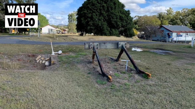
The rail line has been decommissioned and removed.
THE ROUTE

The trail starts at the Mount Morgan Railway Station on Railway Parade to Little James Street, over Gordon Lane, parallel to the left of Old Baree Road, Creek Street, jumps over Razorback Road and runs parallel to the right and then crosses over to the left.
One submitter suggested a lookout and stop among the wattle trees and grevilleas near the Razorback Road and Leydens Hill Road intersection.
The track veers to the west around here towards the direction of Kabra.
The rail trail comes to a bend and then traverses along Hume Road and goes over the McEvoy Road intersection, marking the end of the Razorback climb.
This area was also suggested as a stop and to include water and shelter, or it could be a starting or finishing point for some who may not want to do the whole trail.
From here it cuts through land and meets up with Cherryfield Road, following the left of the road, then to the right of Johnson Road.
The trail ends near Cedric Archer Park, at Johnson Road, Ian Besch Drive and Fisher Street.
Join the conversation

40+ charged with 199 offences in property crime blitz
Read more

Two-car crash: Mackay motorists urged to avoid area
Read more